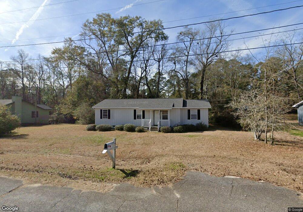
74 Bond St Thomasville, GA 31757
Estimated Value: $181,144 - $223,000
--
Bed
1
Bath
1,200
Sq Ft
$169/Sq Ft
Est. Value
About This Home
This home is located at 74 Bond St, Thomasville, GA 31757 and is currently estimated at $202,786, approximately $168 per square foot. 74 Bond St is a home located in Thomas County with nearby schools including Hand in Hand Primary School, Garrison-Pilcher Elementary School, and Cross Creek Elementary School.
Ownership History
Date
Name
Owned For
Owner Type
Purchase Details
Closed on
May 10, 2017
Sold by
Ward T
Bought by
Gmp Capital Management Llc
Current Estimated Value
Purchase Details
Closed on
Feb 17, 2016
Sold by
Baker Majorie P
Bought by
Ward Capital Management Llc
Home Financials for this Owner
Home Financials are based on the most recent Mortgage that was taken out on this home.
Original Mortgage
$63,500
Interest Rate
3.81%
Mortgage Type
New Conventional
Purchase Details
Closed on
Dec 21, 2015
Sold by
Bank Of America
Bought by
Baker Majorie P
Home Financials for this Owner
Home Financials are based on the most recent Mortgage that was taken out on this home.
Original Mortgage
$63,500
Interest Rate
3.81%
Mortgage Type
New Conventional
Purchase Details
Closed on
Jun 2, 2015
Sold by
Poitevint Glenda
Bought by
Bank Of America
Purchase Details
Closed on
Apr 18, 1996
Bought by
Poitevint Glenda
Create a Home Valuation Report for This Property
The Home Valuation Report is an in-depth analysis detailing your home's value as well as a comparison with similar homes in the area
Home Values in the Area
Average Home Value in this Area
Purchase History
| Date | Buyer | Sale Price | Title Company |
|---|---|---|---|
| Gmp Capital Management Llc | $349,600 | -- | |
| Eric Ward T | -- | -- | |
| Ward Capital Management Llc | $64,680 | -- | |
| Baker Majorie P | $64,680 | -- | |
| Bank Of America | $79,800 | -- | |
| Poitevint Glenda | $35,800 | -- |
Source: Public Records
Mortgage History
| Date | Status | Borrower | Loan Amount |
|---|---|---|---|
| Previous Owner | Ward Capital Management Llc | $63,500 |
Source: Public Records
Tax History Compared to Growth
Tax History
| Year | Tax Paid | Tax Assessment Tax Assessment Total Assessment is a certain percentage of the fair market value that is determined by local assessors to be the total taxable value of land and additions on the property. | Land | Improvement |
|---|---|---|---|---|
| 2024 | $1,311 | $62,774 | $15,180 | $47,594 |
| 2023 | $939 | $45,953 | $13,800 | $32,153 |
| 2022 | $919 | $40,496 | $12,000 | $28,496 |
| 2021 | $911 | $36,290 | $12,000 | $24,290 |
| 2020 | $915 | $35,492 | $12,000 | $23,492 |
| 2019 | $926 | $35,492 | $12,000 | $23,492 |
| 2018 | $939 | $35,258 | $12,000 | $23,258 |
| 2017 | $0 | $34,113 | $10,680 | $23,433 |
| 2016 | $699 | $33,297 | $10,680 | $22,617 |
| 2015 | $952 | $34,268 | $9,960 | $24,308 |
| 2014 | $941 | $33,694 | $9,960 | $23,734 |
| 2013 | -- | $33,694 | $9,960 | $23,734 |
Source: Public Records
Map
Nearby Homes
- 13 Jaan Ct
- 115 Owl Hollow Rd Unit 12
- 246 Whipowill Bend
- 121 Trailwood Dr
- 115 Lakeside Dr
- 111 Greenleaf Ln
- 318 Madison Grove Blvd
- 228 Landover Park
- 347 Madison Grove Blvd
- 321 Madison Grove Blvd
- 125 Pepperdine Ct
- 234 Landover Park
- 311 Madison Grove Blvd
- 120 Pepperdine Ct
- 289 Lake Trace Dr
- 227 Torrington Blvd
- 339 White Blossom Trail
- 290 Lilliquin Dr
- 00 Shoreline Dr
- 195 Cherokee Cir