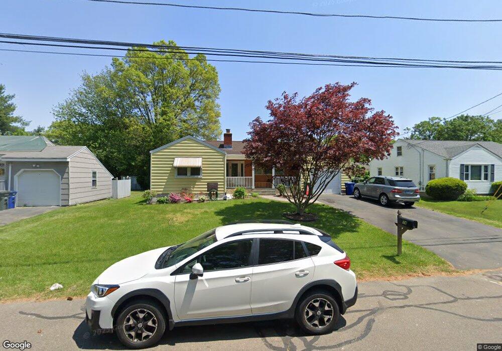
74 Doreen Dr Bridgeport, CT 06604
North End NeighborhoodEstimated Value: $382,000 - $458,368
3
Beds
2
Baths
1,578
Sq Ft
$270/Sq Ft
Est. Value
About This Home
This home is located at 74 Doreen Dr, Bridgeport, CT 06604 and is currently estimated at $426,092, approximately $270 per square foot. 74 Doreen Dr is a home located in Fairfield County with nearby schools including John Winthrop School, Central High School, and St Andrew School.
Ownership History
Date
Name
Owned For
Owner Type
Purchase Details
Closed on
Nov 6, 1997
Sold by
Pisanelli Robert S Est
Bought by
Kkhamhoung Bounnhaseng and Kkhamhoung Ubol
Current Estimated Value
Home Financials for this Owner
Home Financials are based on the most recent Mortgage that was taken out on this home.
Original Mortgage
$104,500
Interest Rate
6.88%
Mortgage Type
Unknown
Create a Home Valuation Report for This Property
The Home Valuation Report is an in-depth analysis detailing your home's value as well as a comparison with similar homes in the area
Home Values in the Area
Average Home Value in this Area
Purchase History
We collect this data history from publicly available records. To have your information removed, we recommend requesting removal directly through your county’s website.
| Date | Buyer | Sale Price | Title Company |
|---|---|---|---|
| Kkhamhoung Bounnhaseng | $110,000 | -- | |
| Kkhamhoung Bounnhaseng | $110,000 | -- |
Source: Public Records
Mortgage History
We collect this data history from publicly available records. To have your information removed, we recommend requesting removal directly through your county’s website.
| Date | Status | Borrower | Loan Amount |
|---|---|---|---|
| Open | Kkhamhoung Bounnhaseng | $167,000 | |
| Closed | Kkhamhoung Bounnhaseng | $171,688 | |
| Closed | Kkhamhoung Bounnhaseng | $105,750 | |
| Closed | Kkhamhoung Bounnhaseng | $104,500 |
Source: Public Records
Tax History
| Year | Tax Paid | Tax Assessment Tax Assessment Total Assessment is a certain percentage of the fair market value that is determined by local assessors to be the total taxable value of land and additions on the property. | Land | Improvement |
|---|---|---|---|---|
| 2025 | $6,961 | $160,200 | $77,800 | $82,400 |
| 2024 | $6,961 | $160,200 | $77,800 | $82,400 |
| 2023 | $6,961 | $160,200 | $77,800 | $82,400 |
| 2022 | $6,961 | $160,200 | $77,800 | $82,400 |
| 2021 | $6,961 | $160,200 | $77,800 | $82,400 |
| 2020 | $7,130 | $132,070 | $60,960 | $71,110 |
| 2019 | $7,130 | $132,070 | $60,960 | $71,110 |
| 2018 | $7,181 | $132,070 | $60,960 | $71,110 |
| 2017 | $7,181 | $132,070 | $60,960 | $71,110 |
| 2016 | $7,181 | $132,070 | $60,960 | $71,110 |
| 2015 | $6,565 | $155,570 | $60,020 | $95,550 |
| 2014 | $6,565 | $155,570 | $60,020 | $95,550 |
Source: Public Records
Map
Nearby Homes
- 170 Marilyn Dr
- 69 Seaver Cir
- 3850 Old Town Rd
- 63 Richfield Rd
- 217 Macon Dr
- 4161 Madison Ave
- 11 Marcy Rd
- 4 Walnut Ave
- 252 Bear Paw Rd
- 3370 Madison Ave Unit 10B
- 18 Ridgebury Dr
- 472 Anton St
- 5633 Park Ave
- 105 Bear Paw Rd
- 15 Cherry Hill Dr Unit 2A
- 185 Cherry Hill Dr Unit 1A
- 50 Greenhouse Rd Unit 26B
- 50 Greenhouse Rd Unit 49C
- 50 Greenhouse Rd Unit 41D
- 50 Greenhouse Rd Unit 33D
Your Personal Tour Guide
Ask me questions while you tour the home.