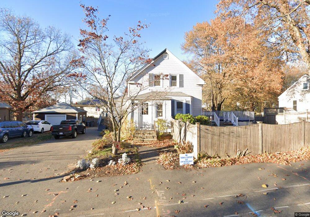
74 Elm St Stoneham, MA 02180
Bear Hill NeighborhoodEstimated Value: $652,000 - $857,098
4
Beds
3
Baths
2,374
Sq Ft
$329/Sq Ft
Est. Value
About This Home
This home is located at 74 Elm St, Stoneham, MA 02180 and is currently estimated at $782,025, approximately $329 per square foot. 74 Elm St is a home located in Middlesex County with nearby schools including Stoneham High School, St. Patrick Elementary School, and St Joseph School.
Ownership History
Date
Name
Owned For
Owner Type
Purchase Details
Closed on
Sep 21, 1994
Sold by
Guilmette Kathleen M
Bought by
Moran Timothy J and Moran Joanne M
Current Estimated Value
Purchase Details
Closed on
Nov 10, 1988
Sold by
Alberta Michael
Bought by
Leonard Mary F
Create a Home Valuation Report for This Property
The Home Valuation Report is an in-depth analysis detailing your home's value as well as a comparison with similar homes in the area
Home Values in the Area
Average Home Value in this Area
Purchase History
| Date | Buyer | Sale Price | Title Company |
|---|---|---|---|
| Moran Timothy J | $128,000 | -- | |
| Leonard Mary F | $220,000 | -- |
Source: Public Records
Mortgage History
| Date | Status | Borrower | Loan Amount |
|---|---|---|---|
| Open | Leonard Mary F | $285,000 | |
| Closed | Leonard Mary F | $225,000 | |
| Closed | Leonard Mary F | $30,000 |
Source: Public Records
Tax History Compared to Growth
Tax History
| Year | Tax Paid | Tax Assessment Tax Assessment Total Assessment is a certain percentage of the fair market value that is determined by local assessors to be the total taxable value of land and additions on the property. | Land | Improvement |
|---|---|---|---|---|
| 2025 | $7,270 | $710,700 | $375,400 | $335,300 |
| 2024 | $7,216 | $681,400 | $345,800 | $335,600 |
| 2023 | $7,234 | $651,700 | $316,100 | $335,600 |
| 2022 | $6,476 | $622,100 | $286,500 | $335,600 |
| 2021 | $5,845 | $540,200 | $247,000 | $293,200 |
| 2020 | $5,788 | $536,400 | $236,500 | $299,900 |
| 2019 | $5,368 | $478,400 | $217,900 | $260,500 |
| 2018 | $5,128 | $437,900 | $216,800 | $221,100 |
| 2017 | $4,796 | $387,100 | $205,900 | $181,200 |
| 2016 | $4,755 | $374,400 | $205,900 | $168,500 |
| 2015 | $4,776 | $368,500 | $186,300 | $182,200 |
| 2014 | $4,596 | $340,700 | $166,700 | $174,000 |
Source: Public Records
Map
Nearby Homes
- 21 Tremont St Unit A
- 1 Tremont St
- 25 Penny Ln
- 106 Elm St
- 34 Duncklee Ave
- 13 Washington Ave
- 32 Garden Rd
- 59 Norval Ave
- 43 Pomeworth St Unit 44
- 8 Steele St
- 20 Myrtle St
- 10 Pomeworth St Unit H
- 159 Main St Unit 41C
- 4 Vernon Ave
- 62 High St Unit 4
- 62 High St Unit 3
- 62 High St Unit Lot 12
- 62 High St Unit Lot 2
- 62 High St Unit Lot 7
- 62 High St Unit Lot 9