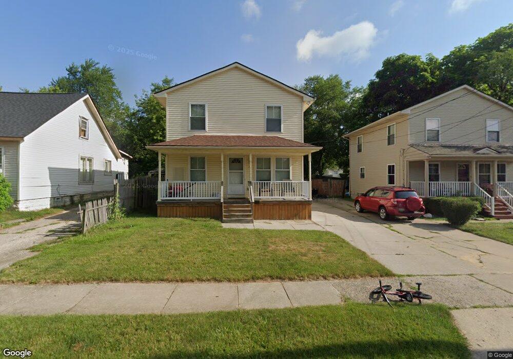
74 Forest St Pontiac, MI 48342
Estimated Value: $103,000 - $154,000
4
Beds
2
Baths
1,074
Sq Ft
$114/Sq Ft
Est. Value
About This Home
This home is located at 74 Forest St, Pontiac, MI 48342 and is currently estimated at $122,107, approximately $113 per square foot. 74 Forest St is a home located in Oakland County with nearby schools including Owen Elementary School, Pontiac Middle School, and Pontiac High School.
Ownership History
Date
Name
Owned For
Owner Type
Purchase Details
Closed on
Aug 14, 2017
Sold by
Wilmington Savings Fund Society
Bought by
Garcia Yuberqui A
Current Estimated Value
Purchase Details
Closed on
May 4, 2006
Sold by
Sngc Llc
Bought by
Christiana Bank & Trust Co and The Security National Funding Trust
Purchase Details
Closed on
Oct 7, 2005
Sold by
Bauer Kristen A and Mca Financial Corporation
Bought by
Sngc Llc and Security National Master Manager Llc
Purchase Details
Closed on
Mar 10, 1998
Sold by
Mortgage Corporation Ame
Bought by
Sterling Bank Trust
Purchase Details
Closed on
Dec 2, 1997
Sold by
C M Developers
Bought by
Mortgage Corporation Amer
Purchase Details
Closed on
Nov 1, 1996
Sold by
Dill Charles H
Bought by
C M Developers
Create a Home Valuation Report for This Property
The Home Valuation Report is an in-depth analysis detailing your home's value as well as a comparison with similar homes in the area
Home Values in the Area
Average Home Value in this Area
Purchase History
| Date | Buyer | Sale Price | Title Company |
|---|---|---|---|
| Garcia Yuberqui A | $33,700 | First American Title Insuran | |
| Christiana Bank & Trust Co | -- | None Available | |
| Sngc Llc | $19,348 | Regency Title | |
| Sterling Bank Trust | -- | -- | |
| Mortgage Corporation Amer | -- | -- | |
| C M Developers | -- | -- |
Source: Public Records
Tax History Compared to Growth
Tax History
| Year | Tax Paid | Tax Assessment Tax Assessment Total Assessment is a certain percentage of the fair market value that is determined by local assessors to be the total taxable value of land and additions on the property. | Land | Improvement |
|---|---|---|---|---|
| 2024 | $508 | $26,870 | $0 | $0 |
| 2023 | $485 | $23,130 | $0 | $0 |
| 2022 | $534 | $19,970 | $0 | $0 |
| 2021 | $519 | $17,590 | $0 | $0 |
| 2020 | $441 | $17,480 | $0 | $0 |
| 2019 | $495 | $15,150 | $0 | $0 |
| 2018 | $467 | $13,540 | $0 | $0 |
| 2017 | $446 | $13,290 | $0 | $0 |
| 2016 | $474 | $13,000 | $0 | $0 |
| 2015 | -- | $12,440 | $0 | $0 |
| 2014 | -- | $11,520 | $0 | $0 |
| 2011 | -- | $16,000 | $0 | $0 |
Source: Public Records
Map
Nearby Homes
- 59 Forest St
- 73 Poplar Ave
- 130 Baldwin Ave
- 123 Adelaide St
- 111 Hamilton St
- 272 Cesar e Chavez Ave
- 217 Edison St
- 320 Cesar e Chavez Ave
- 78 Cadillac St
- 52 Whitfield St
- 0 Baldwin Rd Unit 20251027987
- 0 Baldwin Ave Unit 20240055811
- 124 Kemp St
- 48 Florence St
- 54 Hudson Ave
- 36 Clairmont Place
- 352 N Perry St
- 431 Perry St
- 388 N Perry St
- 11 Lexington Place