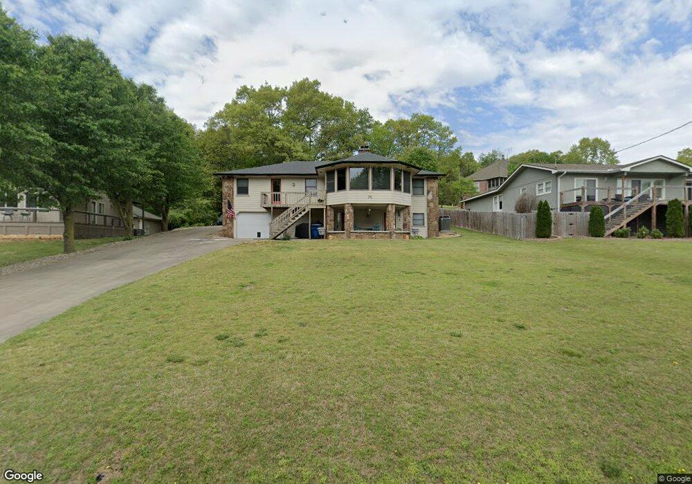
74 Mayfair Dr Bella Vista, AR 72715
Estimated Value: $458,000 - $656,000
3
Beds
4
Baths
3,400
Sq Ft
$153/Sq Ft
Est. Value
About This Home
This home is located at 74 Mayfair Dr, Bella Vista, AR 72715 and is currently estimated at $521,566, approximately $153 per square foot. 74 Mayfair Dr is a home located in Benton County with nearby schools including Cooper Elementary School, Old High Middle School, and Washington Junior High School.
Ownership History
Date
Name
Owned For
Owner Type
Purchase Details
Closed on
Apr 28, 2006
Sold by
Perkins Hoyt E and Perkins Virginia H
Bought by
Turner Laura
Current Estimated Value
Home Financials for this Owner
Home Financials are based on the most recent Mortgage that was taken out on this home.
Original Mortgage
$44,600
Interest Rate
6.36%
Mortgage Type
Stand Alone Second
Purchase Details
Closed on
Nov 17, 1998
Bought by
Perkins
Purchase Details
Closed on
May 20, 1996
Bought by
Perkins
Purchase Details
Closed on
Jul 25, 1980
Bought by
Church
Create a Home Valuation Report for This Property
The Home Valuation Report is an in-depth analysis detailing your home's value as well as a comparison with similar homes in the area
Home Values in the Area
Average Home Value in this Area
Purchase History
| Date | Buyer | Sale Price | Title Company |
|---|---|---|---|
| Turner Laura | $223,000 | None Available | |
| Perkins | -- | -- | |
| Perkins | $159,000 | -- | |
| Church | $13,000 | -- |
Source: Public Records
Mortgage History
| Date | Status | Borrower | Loan Amount |
|---|---|---|---|
| Closed | Turner Laura | $44,600 | |
| Open | Turner Laura | $178,400 |
Source: Public Records
Tax History Compared to Growth
Tax History
| Year | Tax Paid | Tax Assessment Tax Assessment Total Assessment is a certain percentage of the fair market value that is determined by local assessors to be the total taxable value of land and additions on the property. | Land | Improvement |
|---|---|---|---|---|
| 2025 | $2,823 | $81,144 | $1,600 | $79,544 |
| 2024 | $2,668 | $81,144 | $1,600 | $79,544 |
| 2023 | $2,541 | $53,530 | $800 | $52,730 |
| 2022 | $2,134 | $53,530 | $800 | $52,730 |
| 2021 | $2,014 | $53,530 | $800 | $52,730 |
| 2020 | $1,921 | $36,050 | $600 | $35,450 |
| 2019 | $1,921 | $36,050 | $600 | $35,450 |
| 2018 | $1,946 | $36,050 | $600 | $35,450 |
| 2017 | $1,688 | $36,050 | $600 | $35,450 |
| 2016 | $1,688 | $36,050 | $600 | $35,450 |
| 2015 | $1,910 | $31,670 | $1,000 | $30,670 |
| 2014 | $1,560 | $31,670 | $1,000 | $30,670 |
Source: Public Records
Map
Nearby Homes
- Lot 14 of Block 4 Heather Cir
- 9 Connie Ln
- 6 Connie Ln
- 19 Brompton Dr
- 6 Neffwood Ln
- Lot 5 Neffwood Ln
- 22 Pembroke Ln
- 9 Estes Dr
- 21 Estes Dr
- 0 Churchill Dr
- 55 Portsmouth Dr
- 50 Churchill Dr
- 7 Joanie Ln
- Lot 26 Block 2 Kensington Dr
- 30 Cromer Dr
- 18 Worstead Ln
- 26 Cromer Dr
- 4 Frensham Ln
- 13 Kensington Dr
- 36 Churchill Dr