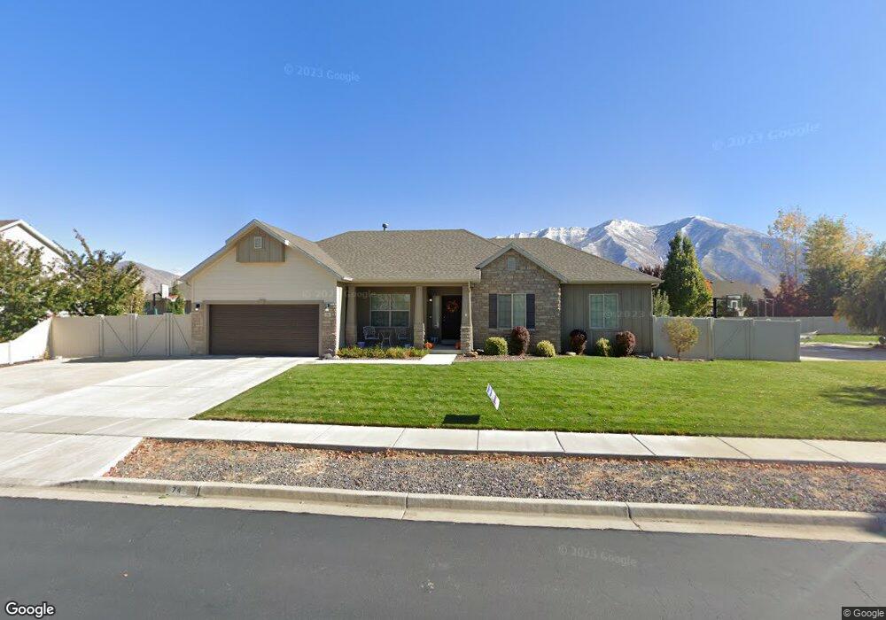
74 N 1650 E Spanish Fork, UT 84660
Estimated Value: $591,000 - $678,000
3
Beds
4
Baths
1,830
Sq Ft
$352/Sq Ft
Est. Value
About This Home
This home is located at 74 N 1650 E, Spanish Fork, UT 84660 and is currently estimated at $643,418, approximately $351 per square foot. 74 N 1650 E is a home with nearby schools including Sierra Bonita Elementary School, Mapleton Junior High School, and Maple Mountain High School.
Ownership History
Date
Name
Owned For
Owner Type
Purchase Details
Closed on
Jun 29, 2009
Sold by
Home By Harmony Inc
Bought by
Nelson Ii Michael D and Nelson Hillary A
Current Estimated Value
Home Financials for this Owner
Home Financials are based on the most recent Mortgage that was taken out on this home.
Original Mortgage
$217,161
Outstanding Balance
$138,236
Interest Rate
4.83%
Mortgage Type
FHA
Estimated Equity
$505,182
Purchase Details
Closed on
Apr 24, 2009
Sold by
Sunny Ridge Plat F Llc
Bought by
Homes By Harmony Inc
Home Financials for this Owner
Home Financials are based on the most recent Mortgage that was taken out on this home.
Original Mortgage
$1,603,200
Interest Rate
4.8%
Mortgage Type
Construction
Purchase Details
Closed on
Aug 20, 2008
Sold by
Jon Fullmer Construction Inc
Bought by
Far West Bank
Create a Home Valuation Report for This Property
The Home Valuation Report is an in-depth analysis detailing your home's value as well as a comparison with similar homes in the area
Home Values in the Area
Average Home Value in this Area
Purchase History
| Date | Buyer | Sale Price | Title Company |
|---|---|---|---|
| Nelson Ii Michael D | -- | Provo Land Title Company | |
| Homes By Harmony Inc | -- | Provo Land Title Company | |
| Far West Bank | $2,530,000 | None Available |
Source: Public Records
Mortgage History
| Date | Status | Borrower | Loan Amount |
|---|---|---|---|
| Open | Nelson Ii Michael D | $217,161 | |
| Previous Owner | Homes By Harmony Inc | $1,603,200 |
Source: Public Records
Tax History
| Year | Tax Paid | Tax Assessment Tax Assessment Total Assessment is a certain percentage of the fair market value that is determined by local assessors to be the total taxable value of land and additions on the property. | Land | Improvement |
|---|---|---|---|---|
| 2025 | $3,049 | $352,220 | -- | -- |
| 2024 | $3,049 | $314,270 | $0 | $0 |
| 2023 | $3,081 | $317,900 | $0 | $0 |
| 2022 | $3,126 | $316,360 | $0 | $0 |
| 2021 | $2,661 | $430,900 | $145,400 | $285,500 |
| 2020 | $2,474 | $389,400 | $132,200 | $257,200 |
| 2019 | $2,197 | $363,800 | $123,800 | $240,000 |
| 2018 | $2,048 | $327,800 | $113,300 | $214,500 |
| 2017 | $2,071 | $178,200 | $0 | $0 |
| 2016 | $1,874 | $159,115 | $0 | $0 |
| 2015 | $1,833 | $153,780 | $0 | $0 |
| 2014 | $1,749 | $147,235 | $0 | $0 |
Source: Public Records
Map
Nearby Homes
- 1455 E 100 S
- 236 S 1800 E
- 1005 E 260 N Unit 20
- 1391 E 290 N
- 2117 E 130 N Unit 59
- 2137 E 200 N Unit MSF53
- 2138 E 200 N Unit COLU
- 2163 E 200 N Unit MSF52
- 1897 E 280 S
- 2131 E 130 N Unit 58
- 1658 Dover Dr
- 2672 E 360 N Unit MRVL09
- 2622 E 360 N Unit MRVL07
- 1495 E 400 N
- 1238 E 100 S
- 1022 E 360 N Unit 27
- 991 E 360 N Unit 8
- 136 N 1120 E
- 1159 E 100 S
- 325 S 1230 E
- 98 N 1650 E
- 58 N 1650 E
- 63 N 1700 E Unit MM148A
- 81 N 1700 E
- 73 N 1650 E
- 51 N 1700 E
- 101 N 1700 E
- 101 N 1700 E Unit 150
- 857 N 1650 E
- 858 N 1650 E
- 825 N 1650 E Unit 123
- 797 N 1650 E Unit 121
- 826 N 1650 E Unit 125
- 798 N 1650 E Unit 126
- 97 N 1650 E
- 1658 E 130 N
- 53 N 1650 E
- 36 N 1650 E
- 831 N 1700 E Unit 128
- 861 N 1700 E Unit 129
Your Personal Tour Guide
Ask me questions while you tour the home.