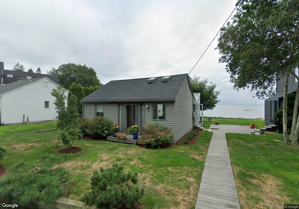
74 Trolley Rd Guilford, CT 06437
Estimated Value: $736,000 - $997,000
2
Beds
1
Bath
720
Sq Ft
$1,212/Sq Ft
Est. Value
About This Home
This home is located at 74 Trolley Rd, Guilford, CT 06437 and is currently estimated at $872,622, approximately $1,211 per square foot. 74 Trolley Rd is a home located in New Haven County with nearby schools including E.C. Adams Middle School, A. Baldwin Middle School, and Guilford High School.
Ownership History
Date
Name
Owned For
Owner Type
Purchase Details
Closed on
Sep 30, 1996
Sold by
Sgroi Anthony and Sgroi Iolanda A
Bought by
Haverly John G
Current Estimated Value
Purchase Details
Closed on
Feb 15, 1991
Sold by
Robinson Norman D and Robinson Elaine F
Bought by
Sgroi Anthony and Sgroi Iolanda A
Home Financials for this Owner
Home Financials are based on the most recent Mortgage that was taken out on this home.
Original Mortgage
$20,000
Interest Rate
9.46%
Mortgage Type
Unknown
Create a Home Valuation Report for This Property
The Home Valuation Report is an in-depth analysis detailing your home's value as well as a comparison with similar homes in the area
Home Values in the Area
Average Home Value in this Area
Purchase History
| Date | Buyer | Sale Price | Title Company |
|---|---|---|---|
| Haverly John G | $250,000 | -- | |
| Sgroi Anthony | $200,000 | -- |
Source: Public Records
Mortgage History
| Date | Status | Borrower | Loan Amount |
|---|---|---|---|
| Previous Owner | Sgroi Anthony | $20,000 |
Source: Public Records
Tax History
| Year | Tax Paid | Tax Assessment Tax Assessment Total Assessment is a certain percentage of the fair market value that is determined by local assessors to be the total taxable value of land and additions on the property. | Land | Improvement |
|---|---|---|---|---|
| 2025 | $15,927 | $576,030 | $531,650 | $44,380 |
| 2024 | $15,311 | $576,030 | $531,650 | $44,380 |
| 2023 | $14,908 | $576,030 | $531,650 | $44,380 |
| 2022 | $13,220 | $397,590 | $374,220 | $23,370 |
| 2021 | $12,969 | $397,590 | $374,220 | $23,370 |
| 2020 | $12,846 | $397,590 | $374,220 | $23,370 |
| 2019 | $12,735 | $397,590 | $374,220 | $23,370 |
| 2018 | $12,437 | $397,590 | $374,220 | $23,370 |
| 2017 | $12,763 | $434,720 | $406,100 | $28,620 |
| 2016 | $12,463 | $434,720 | $406,100 | $28,620 |
| 2015 | $12,276 | $434,720 | $406,100 | $28,620 |
| 2014 | $11,920 | $434,720 | $406,100 | $28,620 |
Source: Public Records
Map
Nearby Homes
- 215 Uncas Point Rd
- 76 Sachem Head Rd
- 575 Leetes Island Rd
- 66 High St Unit 34
- 379 Whitfield St Unit BN334
- 379 Whitfield St Unit CN946
- 379 Whitfield St Unit AN236
- 379 Whitfield St Unit BN2534
- 379 Whitfield St Unit CS936
- 26 Water St
- 285 Old Whitfield St
- 405 Whitfield St Unit 2
- 174 Whitfield St
- 101 Leighton Trail
- 505 Old Whitfield St
- 55 Sawmill Rd Unit 69
- 52 Fair St
- 156 Stone House Ln
- 80 Seaview Terrace Unit 7
- 147 Boston St
- 68 Trolley Rd
- 82 Trolley Rd
- 64 Trolley Rd
- 84 Trolley Rd
- 73 Trolley Rd
- 89 Trolley Rd
- 0 Bayberry Ln Unit N335571
- 65 Trolley Rd
- 6 Waterside Dr
- 25 Waterside Dr
- 20 Waterside Dr
- 51 Trolley Rd
- 99 Trolley Rd
- 31 Waterside Dr
- 37 Waterside Dr
- 111 Trolley Rd
- 21 Bayberry Ln
- 26 Waterside Dr
- 30 Bayberry Ln
- 33 Trolley Rd
Your Personal Tour Guide
Ask me questions while you tour the home.