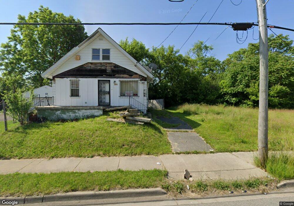
740 E Pierson Rd Flint, MI 48505
Northeast Village NeighborhoodEstimated Value: $24,207 - $83,000
2
Beds
1
Bath
624
Sq Ft
$86/Sq Ft
Est. Value
About This Home
This home is located at 740 E Pierson Rd, Flint, MI 48505 and is currently estimated at $53,604, approximately $85 per square foot. 740 E Pierson Rd is a home located in Genesee County with nearby schools including Brownell STEM Academy, The New Standard Academy, and Eagle's Nest Academy.
Ownership History
Date
Name
Owned For
Owner Type
Purchase Details
Closed on
Dec 17, 2015
Sold by
Genesee County
Bought by
Genesee County Land Bank
Current Estimated Value
Purchase Details
Closed on
Jul 14, 2005
Sold by
Tenniswood Timothy L
Bought by
Kdt Investments Llc
Purchase Details
Closed on
Jul 11, 2005
Sold by
Klauka Pamela A
Bought by
Tenniswood Timothy
Purchase Details
Closed on
Jun 30, 1999
Sold by
Owens Jerry Dee
Bought by
Security Fcu
Create a Home Valuation Report for This Property
The Home Valuation Report is an in-depth analysis detailing your home's value as well as a comparison with similar homes in the area
Home Values in the Area
Average Home Value in this Area
Purchase History
| Date | Buyer | Sale Price | Title Company |
|---|---|---|---|
| Genesee County Land Bank | -- | None Available | |
| Kdt Investments Llc | -- | -- | |
| Tenniswood Timothy | $21,000 | Sargents Title Company | |
| Klauka Pamela A | -- | Sargents Title Company | |
| Security Fcu | $8,254 | -- |
Source: Public Records
Tax History Compared to Growth
Tax History
| Year | Tax Paid | Tax Assessment Tax Assessment Total Assessment is a certain percentage of the fair market value that is determined by local assessors to be the total taxable value of land and additions on the property. | Land | Improvement |
|---|---|---|---|---|
| 2025 | -- | $0 | $0 | $0 |
| 2024 | -- | $0 | $0 | $0 |
| 2023 | -- | $0 | $0 | $0 |
| 2022 | $0 | $0 | $0 | $0 |
| 2021 | $0 | $0 | $0 | $0 |
| 2020 | $0 | $0 | $0 | $0 |
| 2019 | $0 | $0 | $0 | $0 |
| 2018 | $0 | $0 | $0 | $0 |
| 2017 | $0 | $0 | $0 | $0 |
| 2016 | $0 | $0 | $0 | $0 |
| 2015 | -- | $0 | $0 | $0 |
| 2014 | -- | $0 | $0 | $0 |
| 2012 | -- | $4,500 | $0 | $0 |
Source: Public Records
Map
Nearby Homes
- 0 E Marengo Ave Unit 50166417
- 726 E Parkway Ave
- 680 E Pierson Rd
- 914 Lomita Ave
- 618 E Parkway Ave
- 618 E Pulaski Ave
- 733 Black Ave
- 350 E Mott Ave
- 802 E Russell Ave
- 00 E Russell Ave
- 4028 North St
- 370 E Moore St
- 606 Damon St
- 418 Damon St
- 313 Edwin Ave
- 345 E Austin Ave
- 225 E Piper Ave
- 638 E Foss Ave
- 418 E Foss Ave
- 124 W Flint Park Blvd
- 744 E Pierson Rd
- 728 E Pierson Rd
- 741 Lomita Ave
- 729 Lomita Ave
- 745 Lomita Ave
- 743 E Pierson Rd
- 739 E Pierson Rd
- 735 E Pierson Rd
- 719 Lomita Ave
- 727 E Pierson Rd
- 720 E Pierson Rd
- 744 Lomita Ave
- 732 Lomita Ave
- 723 E Pierson Rd
- 736 Lomita Ave
- 748 Lomita Ave
- 764 E Pierson Rd
- 756 Lomita Ave
- 722 Lomita Ave
- 760 Lomita Ave