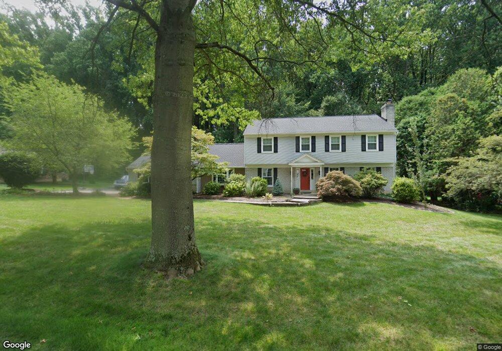
740 Isaac Taylor Dr West Chester, PA 19382
Estimated Value: $889,678 - $1,020,000
4
Beds
4
Baths
2,912
Sq Ft
$323/Sq Ft
Est. Value
About This Home
This home is located at 740 Isaac Taylor Dr, West Chester, PA 19382 and is currently estimated at $939,920, approximately $322 per square foot. 740 Isaac Taylor Dr is a home located in Chester County with nearby schools including Pocopson Elementary School, Charles F. Patton Middle School, and Unionville High School.
Ownership History
Date
Name
Owned For
Owner Type
Purchase Details
Closed on
Jun 27, 2007
Sold by
Stader James F and Stader Clara Z
Bought by
Burke Brian A and Burke Lea M
Current Estimated Value
Home Financials for this Owner
Home Financials are based on the most recent Mortgage that was taken out on this home.
Original Mortgage
$396,000
Outstanding Balance
$247,254
Interest Rate
6.48%
Mortgage Type
Purchase Money Mortgage
Estimated Equity
$692,666
Create a Home Valuation Report for This Property
The Home Valuation Report is an in-depth analysis detailing your home's value as well as a comparison with similar homes in the area
Home Values in the Area
Average Home Value in this Area
Purchase History
| Date | Buyer | Sale Price | Title Company |
|---|---|---|---|
| Burke Brian A | $495,000 | None Available |
Source: Public Records
Mortgage History
| Date | Status | Borrower | Loan Amount |
|---|---|---|---|
| Open | Burke Brian A | $396,000 |
Source: Public Records
Tax History Compared to Growth
Tax History
| Year | Tax Paid | Tax Assessment Tax Assessment Total Assessment is a certain percentage of the fair market value that is determined by local assessors to be the total taxable value of land and additions on the property. | Land | Improvement |
|---|---|---|---|---|
| 2025 | $9,931 | $256,600 | $60,500 | $196,100 |
| 2024 | $9,931 | $256,600 | $60,500 | $196,100 |
| 2023 | $9,618 | $256,600 | $60,500 | $196,100 |
| 2022 | $9,420 | $256,600 | $60,500 | $196,100 |
| 2021 | $9,192 | $256,600 | $60,500 | $196,100 |
| 2020 | $9,168 | $256,600 | $60,500 | $196,100 |
| 2019 | $9,001 | $256,600 | $60,500 | $196,100 |
| 2018 | $8,976 | $256,600 | $60,500 | $196,100 |
| 2017 | $8,791 | $256,600 | $60,500 | $196,100 |
| 2016 | $960 | $256,600 | $60,500 | $196,100 |
| 2015 | $960 | $242,080 | $60,510 | $181,570 |
| 2014 | $960 | $242,080 | $60,510 | $181,570 |
Source: Public Records
Map
Nearby Homes
- 1702 W Street Rd
- 30 Penn Dr
- 7 Bittersweet Dr
- 2005 W Street Rd
- 1740 Lenape Rd
- 1435 Lenape Rd
- 523 Radek Ct
- 4 Sloan Rd
- 1936 Lenape Rd
- 741 Haines Mill Rd
- 0 Haines Mill Rd
- 1185 W Street Rd
- 49 Partridge Ln
- 1315 Lenape Rd
- 1303 Lenape Rd
- 4 W Pennsbury Way
- 1125 Mews Ln Unit 16
- 765 Folly Hill Rd
- 275 S Creek Rd
- 519 Baltimore Pike
- 742 Isaac Taylor Dr
- 738 Isaac Taylor Dr
- 739 Isaac Taylor Dr
- 737 Isaac Taylor Dr
- 736 Isaac Taylor Dr
- 744 Isaac Taylor Dr
- 741 Isaac Taylor Dr
- 735 Isaac Taylor Dr
- 745 Isaac Taylor Dr
- 734 Isaac Taylor Dr
- 1087 Parkerville Rd
- 733 Isaac Taylor Dr
- 743 Isaac Taylor Dr
- 1071 Parkerville Rd
- 812 Nathan Hale Dr
- 732 Isaac Taylor Dr
- 1021 Parkerville Rd
- 1037 Parkerville Rd
- 806 Nathan Hale Dr
- 731 Isaac Taylor Dr