Estimated Value: $68,482 - $122,000
--
Bed
--
Bath
1,032
Sq Ft
$91/Sq Ft
Est. Value
About This Home
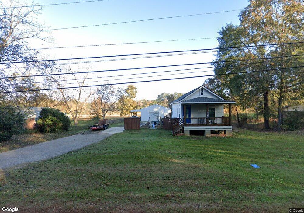
This home is located at 740 Ponder St, Many, LA 71449 and is currently estimated at $94,121, approximately $91 per square foot. 740 Ponder St is a home located in Sabine Parish with nearby schools including Many Junior High School and Many High School.
Ownership History
Date
Name
Owned For
Owner Type
Purchase Details
Closed on
Oct 19, 2018
Sold by
Savell David M and Manasco-Savell Amber
Bought by
Brantley Charles
Current Estimated Value
Purchase Details
Closed on
Oct 29, 2008
Sold by
Spears John Charles
Bought by
Savell David Michael and Savell Amber Manasco
Home Financials for this Owner
Home Financials are based on the most recent Mortgage that was taken out on this home.
Original Mortgage
$54,081
Interest Rate
6.18%
Mortgage Type
New Conventional
Create a Home Valuation Report for This Property
The Home Valuation Report is an in-depth analysis detailing your home's value as well as a comparison with similar homes in the area
Home Values in the Area
Average Home Value in this Area
Purchase History
| Date | Buyer | Sale Price | Title Company |
|---|---|---|---|
| Brantley Charles | $60,000 | -- | |
| Savell David Michael | $49,500 | None Available |
Source: Public Records
Mortgage History
| Date | Status | Borrower | Loan Amount |
|---|---|---|---|
| Previous Owner | Savell David Michael | $54,081 |
Source: Public Records
Tax History Compared to Growth
Tax History
| Year | Tax Paid | Tax Assessment Tax Assessment Total Assessment is a certain percentage of the fair market value that is determined by local assessors to be the total taxable value of land and additions on the property. | Land | Improvement |
|---|---|---|---|---|
| 2024 | $28 | $5,643 | $420 | $5,223 |
| 2023 | $25 | $4,662 | $389 | $4,273 |
| 2022 | $416 | $4,662 | $389 | $4,273 |
| 2021 | $445 | $4,662 | $389 | $4,273 |
| 2020 | $481 | $4,662 | $389 | $4,273 |
| 2019 | $467 | $4,662 | $389 | $4,273 |
| 2018 | $370 | $3,510 | $1,100 | $2,410 |
| 2017 | $369 | $3,510 | $1,100 | $2,410 |
| 2016 | $367 | $3,510 | $1,100 | $2,410 |
| 2015 | $341 | $3,510 | $1,100 | $2,410 |
| 2014 | -- | $3,510 | $1,100 | $2,410 |
Source: Public Records
Map
Nearby Homes
- 00 Chasin Fin Dr Unit 5
- 135 Jarred Ln Unit 27
- 00 Chasin Fin Dr Unit 2
- 00 Chasin Fin Dr Unit 4
- 00 Chasin Fin Dr Unit 7
- 0 Chasin Fin Dr Unit 1 11419405
- 0 Vicky Ln Unit 11227108
- 695 San Antonio Ave
- TBD Route 6
- 1220 San Antonio Ave
- 825 Shreveport Hwy
- 825 Shreveport Hwy Unit 8 & 9 Blk 14
- 850 Hill St
- 245 Marthaville Rd
- 275 Marthaville Rd
- 295 Highland Ave
- 1113 Alieze St
- 000 Texas Hwy
- 0 Texas Hwy Unit 11330283
- 0 Texas Hwy Unit 11438353