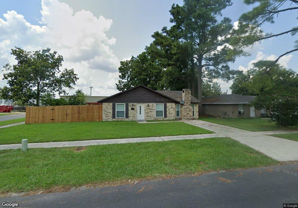
741 Heliotrope St Port Allen, LA 70767
Estimated Value: $148,000 - $206,000
--
Bed
--
Bath
1,408
Sq Ft
$117/Sq Ft
Est. Value
About This Home
This home is located at 741 Heliotrope St, Port Allen, LA 70767 and is currently estimated at $164,108, approximately $116 per square foot. 741 Heliotrope St is a home located in West Baton Rouge Parish with nearby schools including Port Allen Elementary School, Cohn Elementary School, and Port Allen Middle School.
Ownership History
Date
Name
Owned For
Owner Type
Purchase Details
Closed on
Nov 4, 2021
Sold by
Breia Gordon
Bought by
Isaac Gerald John
Current Estimated Value
Home Financials for this Owner
Home Financials are based on the most recent Mortgage that was taken out on this home.
Original Mortgage
$124,208
Outstanding Balance
$113,640
Interest Rate
2.88%
Mortgage Type
FHA
Estimated Equity
$50,468
Purchase Details
Closed on
Dec 26, 2018
Sold by
Snell Debra A and Cazes Michael B
Bought by
Gordon Kenneth and Gordon Breia
Create a Home Valuation Report for This Property
The Home Valuation Report is an in-depth analysis detailing your home's value as well as a comparison with similar homes in the area
Home Values in the Area
Average Home Value in this Area
Purchase History
| Date | Buyer | Sale Price | Title Company |
|---|---|---|---|
| Isaac Gerald John | -- | Legacy Title | |
| Gordon Kenneth | $37,000 | -- |
Source: Public Records
Mortgage History
| Date | Status | Borrower | Loan Amount |
|---|---|---|---|
| Open | Isaac Gerald John | $124,208 | |
| Closed | Isaac Gerald John | $124,208 |
Source: Public Records
Tax History Compared to Growth
Tax History
| Year | Tax Paid | Tax Assessment Tax Assessment Total Assessment is a certain percentage of the fair market value that is determined by local assessors to be the total taxable value of land and additions on the property. | Land | Improvement |
|---|---|---|---|---|
| 2024 | $448 | $10,770 | $3,000 | $7,770 |
| 2023 | $84 | $6,900 | $2,500 | $4,400 |
| 2022 | $808 | $6,900 | $2,500 | $4,400 |
| 2021 | $824 | $6,900 | $2,500 | $4,400 |
| 2020 | $748 | $6,210 | $2,250 | $3,960 |
| 2019 | $848 | $6,740 | $1,490 | $5,250 |
| 2018 | $862 | $6,740 | $1,490 | $5,250 |
| 2017 | $802 | $6,740 | $1,490 | $5,250 |
| 2015 | $659 | $6,670 | $1,420 | $5,250 |
| 2014 | $652 | $6,670 | $1,420 | $5,250 |
| 2013 | $652 | $6,670 | $1,420 | $5,250 |
Source: Public Records
Map
Nearby Homes
- 245 Melissa Dr
- 309 N 14th St
- 289 Melissa Dr
- 3459 Louisiana 1
- 823 Oaks Ave
- 809 Avenue E
- 811 Avenue D
- 835 Whitehead Blvd
- 557 Avenue C
- 2165 Taylor Dr
- 755 Maryland Ave
- 235 N Jefferson Ave
- 550 S River Rd
- 2240 Sherri's Way
- 2188 Sherri's
- 2108 Sherri's
- 2096 Sherri's
- 2168 Sherri's Way
- 2178 Sherri's Way
- 2260 Sherri's Way
- 741 Heliotrope St Unit 1
- 729 Heliotrope St
- 717 Heliotrope St
- 1519 Avenue G
- 1511 Avenue G
- 711 Heliotrope St
- 738 Heliotrope St
- 730 Heliotrope St
- 1459 Avenue G
- 722 Harry Brown St
- 722 Heliotrope St
- 641 Heliotrope St
- 714 Harry Brown St
- 714 Heliotrope St
- 1451 Avenue G
- 633 Heliotrope St
- 1440 Avenue G
- 638 Heliotrope St
- 727 Gladiolus St
- 1443 Avenue G