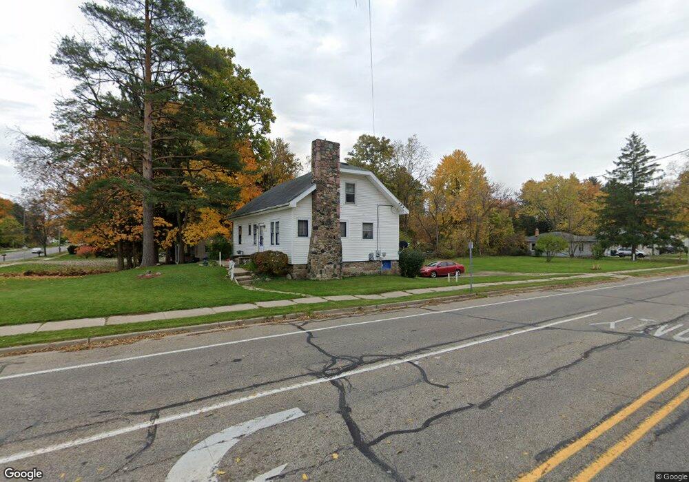
741 W Miller Rd Lansing, MI 48911
Southern Lansing NeighborhoodEstimated Value: $137,000 - $163,000
3
Beds
1
Bath
1,200
Sq Ft
$123/Sq Ft
Est. Value
About This Home
This home is located at 741 W Miller Rd, Lansing, MI 48911 and is currently estimated at $148,005, approximately $123 per square foot. 741 W Miller Rd is a home located in Ingham County with nearby schools including Reo Elementary School, Attwood School, and Everett High School.
Ownership History
Date
Name
Owned For
Owner Type
Purchase Details
Closed on
Feb 3, 2022
Sold by
Verlin Joseph T and Verlin Betty J
Bought by
Verlin Joseph T and Verlin Betty J
Current Estimated Value
Purchase Details
Closed on
Sep 30, 1999
Sold by
Tuttle Patricia Lynn
Bought by
Verlin Joseph Thomas
Purchase Details
Closed on
May 12, 1999
Sold by
Woodworth Francis Pearl and Woodworth Cheryl Louise
Bought by
Verlin Joseph Thomas and Tuttle Patricia Lynn
Purchase Details
Closed on
Jun 19, 1997
Sold by
Litrenta Carlo F
Bought by
Woodworth Francis P and Woodworth Cheryl
Create a Home Valuation Report for This Property
The Home Valuation Report is an in-depth analysis detailing your home's value as well as a comparison with similar homes in the area
Home Values in the Area
Average Home Value in this Area
Purchase History
We collect this data history from publicly available records. To have your information removed, we recommend requesting removal directly through your county’s website.
| Date | Buyer | Sale Price | Title Company |
|---|---|---|---|
| Verlin Joseph T | -- | None Listed On Document | |
| Verlin Joseph T | -- | None Listed On Document | |
| Verlin Joseph Thomas | -- | -- | |
| Verlin Joseph Thomas | $47,000 | -- | |
| Woodworth Francis P | $37,900 | -- |
Source: Public Records
Tax History
| Year | Tax Paid | Tax Assessment Tax Assessment Total Assessment is a certain percentage of the fair market value that is determined by local assessors to be the total taxable value of land and additions on the property. | Land | Improvement |
|---|---|---|---|---|
| 2025 | $3,005 | $62,800 | $11,100 | $51,700 |
| 2024 | $25 | $53,600 | $11,100 | $42,500 |
| 2023 | $2,828 | $47,600 | $11,100 | $36,500 |
| 2022 | $2,582 | $44,000 | $13,300 | $30,700 |
| 2021 | $2,522 | $39,000 | $9,600 | $29,400 |
| 2020 | $2,505 | $36,100 | $9,600 | $26,500 |
| 2019 | $2,420 | $32,100 | $9,600 | $22,500 |
| 2018 | $2,295 | $29,900 | $9,600 | $20,300 |
| 2017 | $2,209 | $29,900 | $9,600 | $20,300 |
| 2016 | $2,121 | $29,500 | $9,600 | $19,900 |
| 2015 | $2,121 | $28,800 | $19,264 | $9,536 |
| 2014 | $2,121 | $28,700 | $22,953 | $5,747 |
Source: Public Records
Map
Nearby Homes
- 6265 Marywood Ave
- 6223 Hilliard Rd
- 6253 Hilliard Rd
- 6054 Daft St
- 826 R G Curtiss Ave
- 6421 S Washington Ave
- 6444 Sommerset Rd
- 5601 S Washington Ave
- 809 W Northrup St
- 1006 Attwood Dr
- 6062 Valencia Blvd
- 1309 Penrod Ct
- 208 E Northrup St
- 6910 Calson Dr
- 1001 Ferley St
- 5810 Cartago Dr
- 5838 S Martin Luther King Junior Blvd
- 419 W Jolly Rd
- 5815 Caleta Dr
- 0 W Jolly Rd
- 733 W Miller Rd
- 733 W Ller
- 801 W Miller Rd
- 727 W Miller Rd
- 6125 S Washington Ave
- 6120 S Washington Ave
- 6201 S Washington Ave
- 719 W Miller Rd
- 811 W Miller Rd
- 6128 S Washington Ave
- 6209 S Washington Ave
- 819 W Ller
- 819 W Miller Rd
- 711 W Miller Rd
- 6206 S Washington Ave
- 6128 Cooper Rd
- 6211 S Washington Ave
- 825 W Miller Rd
- 6100 Cooper Rd
- 6121 Marywood Ave
Your Personal Tour Guide
Ask me questions while you tour the home.