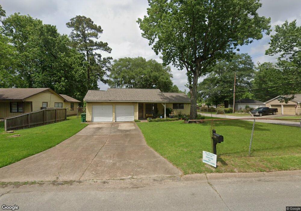
7417 Bretshire Dr Houston, TX 77016
East Little York NeighborhoodEstimated Value: $141,550 - $165,000
3
Beds
2
Baths
967
Sq Ft
$157/Sq Ft
Est. Value
About This Home
This home is located at 7417 Bretshire Dr, Houston, TX 77016 and is currently estimated at $152,138, approximately $157 per square foot. 7417 Bretshire Dr is a home located in Harris County with nearby schools including Shadydale Elementary School, Forest Brook Middle, and North Forest High School.
Ownership History
Date
Name
Owned For
Owner Type
Purchase Details
Closed on
Sep 29, 2004
Sold by
Batiste Redrick D and Harrell Tracey M
Bought by
Batiste Brenda Gail
Current Estimated Value
Purchase Details
Closed on
May 24, 2001
Sold by
Batiste Brenda Gail
Bought by
Batiste Roderick and Harrell Tracey M
Purchase Details
Closed on
Dec 3, 1998
Sold by
Batute Brenda Davis
Bought by
Batute Radrick Delman
Create a Home Valuation Report for This Property
The Home Valuation Report is an in-depth analysis detailing your home's value as well as a comparison with similar homes in the area
Home Values in the Area
Average Home Value in this Area
Purchase History
| Date | Buyer | Sale Price | Title Company |
|---|---|---|---|
| Batiste Brenda Gail | -- | -- | |
| Batiste Roderick | -- | -- | |
| Batute Radrick Delman | -- | -- |
Source: Public Records
Tax History Compared to Growth
Tax History
| Year | Tax Paid | Tax Assessment Tax Assessment Total Assessment is a certain percentage of the fair market value that is determined by local assessors to be the total taxable value of land and additions on the property. | Land | Improvement |
|---|---|---|---|---|
| 2025 | $1,482 | $125,162 | $52,676 | $72,486 |
| 2024 | $1,482 | $120,380 | $52,676 | $67,704 |
| 2023 | $1,482 | $128,119 | $43,594 | $84,525 |
| 2022 | $1,472 | $104,011 | $36,328 | $67,683 |
| 2021 | $1,416 | $88,922 | $27,246 | $61,676 |
| 2020 | $1,338 | $79,493 | $18,891 | $60,602 |
| 2019 | $1,271 | $71,531 | $12,424 | $59,107 |
| 2018 | $0 | $57,161 | $12,424 | $44,737 |
| 2017 | $1,050 | $57,161 | $12,424 | $44,737 |
| 2016 | $954 | $57,161 | $12,424 | $44,737 |
| 2015 | -- | $43,780 | $12,424 | $31,356 |
| 2014 | -- | $34,068 | $12,424 | $21,644 |
Source: Public Records
Map
Nearby Homes
- 7314 Sterlingshire St
- 7338 Bigwood St
- 0 Wileyvale Rd Unit 37533417
- 0 Laura Koppe Rd Unit 64066450
- 0 Lockwood Unit 97801497
- 0 Wileyvale Rd Unit 98938709
- 7242 Bretshire Dr
- 0 Bretshire Dr Unit 83088734
- 0 Bretshire Dr Unit 61965426
- 7218 Bretshire Dr
- 7611 Cabot St
- 9702 Crofton St
- 7603 Caddo Rd
- 7305 Yoe St
- 7402 Yoe St
- 9437 Pembrook St
- 7252 Parker Rd
- 7220 Parker Rd
- 7639 Bigwood St
- 7306 Parker Rd
- 7413 Bretshire Dr
- 7409 Claiborne St
- 7427 Bretshire Dr
- 7409 Bretshire Dr
- 7408 Claiborne St
- 7413 Claiborne St
- 7405 Bretshire Dr
- 7431 Bretshire Dr
- 7408 Cabot St
- 7414 Claiborne St
- 7417 Claiborne St
- 7412 Cabot St
- 7416 Cabot St
- 7435 Bretshire Dr
- 7421 Claiborne St
- 7420 Claiborne St
- 7420 Cabot St
- 7439 Bretshire Dr
- 7424 Cabot St
- 7425 Claiborne St