Estimated Value: $260,289 - $327,000
2
Beds
1
Bath
1,620
Sq Ft
$179/Sq Ft
Est. Value
About This Home
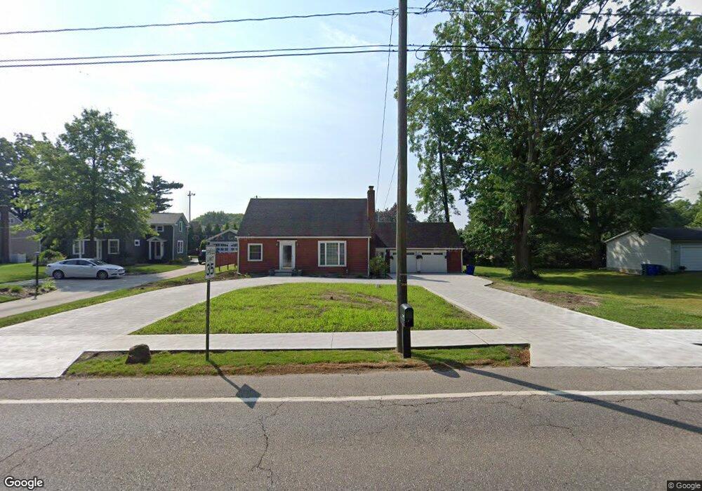
This home is located at 7420 State Route 43, Kent, OH 44240 and is currently estimated at $290,322, approximately $179 per square foot. 7420 State Route 43 is a home located in Portage County with nearby schools including Walls Elementary School, Stanton Middle School, and Theodore Roosevelt High School.
Ownership History
Date
Name
Owned For
Owner Type
Purchase Details
Closed on
Jul 31, 2025
Sold by
Vlacovsky Mark
Bought by
Vlacovsky Mark and Vlacovsky Erika
Current Estimated Value
Purchase Details
Closed on
Mar 18, 2005
Sold by
Horner Donald E and Horner Marian A
Bought by
Vlacovsky Mark
Home Financials for this Owner
Home Financials are based on the most recent Mortgage that was taken out on this home.
Original Mortgage
$130,500
Interest Rate
5.67%
Mortgage Type
Fannie Mae Freddie Mac
Purchase Details
Closed on
Jan 1, 1990
Bought by
Horner Donald E
Create a Home Valuation Report for This Property
The Home Valuation Report is an in-depth analysis detailing your home's value as well as a comparison with similar homes in the area
Home Values in the Area
Average Home Value in this Area
Purchase History
| Date | Buyer | Sale Price | Title Company |
|---|---|---|---|
| Vlacovsky Mark | -- | None Listed On Document | |
| Vlacovsky Mark | $145,000 | Village Title Agency | |
| Horner Donald E | -- | -- |
Source: Public Records
Mortgage History
| Date | Status | Borrower | Loan Amount |
|---|---|---|---|
| Previous Owner | Vlacovsky Mark | $130,500 |
Source: Public Records
Tax History Compared to Growth
Tax History
| Year | Tax Paid | Tax Assessment Tax Assessment Total Assessment is a certain percentage of the fair market value that is determined by local assessors to be the total taxable value of land and additions on the property. | Land | Improvement |
|---|---|---|---|---|
| 2024 | $4,028 | $86,000 | $20,440 | $65,560 |
| 2023 | $3,629 | $62,270 | $20,440 | $41,830 |
| 2022 | $3,619 | $62,270 | $20,440 | $41,830 |
| 2021 | $3,608 | $62,270 | $20,440 | $41,830 |
| 2020 | $3,605 | $55,580 | $20,440 | $35,140 |
| 2019 | $3,561 | $55,580 | $20,440 | $35,140 |
| 2018 | $3,066 | $46,000 | $15,720 | $30,280 |
| 2017 | $3,066 | $46,000 | $15,720 | $30,280 |
| 2016 | $3,036 | $46,000 | $15,720 | $30,280 |
| 2015 | $3,037 | $46,000 | $15,720 | $30,280 |
| 2014 | $3,090 | $46,000 | $15,720 | $30,280 |
| 2013 | $3,067 | $46,000 | $15,720 | $30,280 |
Source: Public Records
Map
Nearby Homes
- 7532 State Route 43
- 7357 Sylvan Dr
- 7263 State Route 43
- 7447 Sylvan Dr
- 1367 Mockingbird Dr
- 7723 W Lake Blvd
- 1508 Ridgecrest Dr
- 7663 Diagonal Rd
- 1939 Pine Dr Unit 8M
- 7775 Diagonal Rd
- 2011 E Swan Lake Cir
- 8158 State Route 43
- 8291 State Route 14
- 1985 Walton Rd
- 2242 Coffeen St
- 409 W Grant St
- 1448 Jude Ave
- 1675 Duncan Way
- 474 W Grant St
- 1678 Duncan Way
- 7424 State Route 43
- 7406 State Route 43
- 7430 State Route 43
- 7439 State Route 43
- 7434 State Route 43
- 7447 State Route 43
- 7419 State Route 43
- 1490 Merrill Ave
- 7453 State Route 43
- 7440 State Route 43
- 1480 Merrill Ave
- 7448 State Route 43
- 7394 State Route 43
- 7384 State Route 43
- 7401 State Route 43
- 7450 State Route 43
- 1491 Merrill Ave
- 1501 Merrill Ave
- 1513 Merrill Ave
- 1521 Merrill Ave