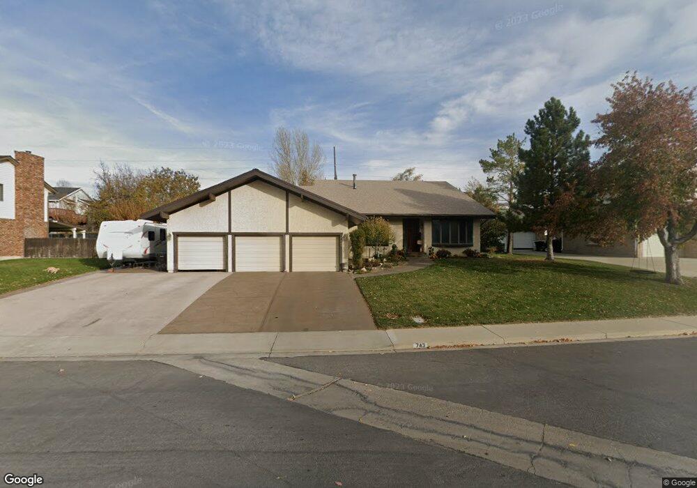
743 E 1050 S Spanish Fork, UT 84660
Estimated Value: $531,000 - $697,000
3
Beds
2
Baths
2,535
Sq Ft
$252/Sq Ft
Est. Value
About This Home
This home is located at 743 E 1050 S, Spanish Fork, UT 84660 and is currently estimated at $638,713, approximately $251 per square foot. 743 E 1050 S is a home located in Utah County with nearby schools including Canyon Elementary School, Spanish Fork Jr High School, and Spanish Fork High School.
Ownership History
Date
Name
Owned For
Owner Type
Purchase Details
Closed on
Jul 31, 2014
Sold by
James Don R
Bought by
Orton David W and Orton Angela
Current Estimated Value
Home Financials for this Owner
Home Financials are based on the most recent Mortgage that was taken out on this home.
Original Mortgage
$197,600
Outstanding Balance
$150,782
Interest Rate
4.13%
Mortgage Type
New Conventional
Estimated Equity
$487,931
Purchase Details
Closed on
Mar 23, 2011
Sold by
Fratt Thomasine P and James Thomasine P Fratt
Bought by
James Thomasine P Fratt
Create a Home Valuation Report for This Property
The Home Valuation Report is an in-depth analysis detailing your home's value as well as a comparison with similar homes in the area
Home Values in the Area
Average Home Value in this Area
Purchase History
| Date | Buyer | Sale Price | Title Company |
|---|---|---|---|
| Orton David W | -- | Wasatch Land & Title | |
| James Thomasine P Fratt | -- | None Available |
Source: Public Records
Mortgage History
| Date | Status | Borrower | Loan Amount |
|---|---|---|---|
| Open | Orton David W | $197,600 |
Source: Public Records
Tax History Compared to Growth
Tax History
| Year | Tax Paid | Tax Assessment Tax Assessment Total Assessment is a certain percentage of the fair market value that is determined by local assessors to be the total taxable value of land and additions on the property. | Land | Improvement |
|---|---|---|---|---|
| 2025 | $2,872 | $332,530 | $202,100 | $402,500 |
| 2024 | $2,872 | $296,010 | $0 | $0 |
| 2023 | $2,858 | $294,910 | $0 | $0 |
| 2022 | $2,748 | $278,135 | $0 | $0 |
| 2021 | $2,361 | $382,200 | $120,700 | $261,500 |
| 2020 | $2,194 | $345,300 | $109,700 | $235,600 |
| 2019 | $2,048 | $339,200 | $103,600 | $235,600 |
| 2018 | $2,016 | $322,700 | $95,900 | $226,800 |
| 2017 | $1,965 | $169,070 | $0 | $0 |
| 2016 | $1,467 | $124,575 | $0 | $0 |
| 2015 | $1,485 | $124,575 | $0 | $0 |
| 2014 | $1,480 | $124,575 | $0 | $0 |
Source: Public Records
Map
Nearby Homes