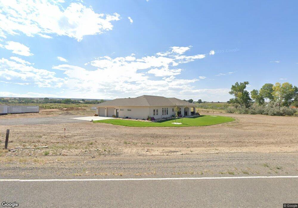
7437 5500 Rd Olathe, CO 81425
Estimated Value: $695,000 - $772,340
3
Beds
3
Baths
2,326
Sq Ft
$314/Sq Ft
Est. Value
About This Home
This home is located at 7437 5500 Rd, Olathe, CO 81425 and is currently estimated at $730,085, approximately $313 per square foot. 7437 5500 Rd is a home located in Montrose County with nearby schools including Olathe Elementary School, Olathe Middle and High School, and Olathe Middle School.
Ownership History
Date
Name
Owned For
Owner Type
Purchase Details
Closed on
Dec 28, 2017
Sold by
Alexnader Joe B and Alexnader Martann
Bought by
Alexander Joe B and Alexander Matyyann
Current Estimated Value
Purchase Details
Closed on
Jan 31, 2007
Sold by
Alexander Joe B and Alexander Maryann
Bought by
Fisher Carl P and Fisher Lacy L
Purchase Details
Closed on
Feb 20, 1965
Sold by
Lekas Mitchell A
Bought by
Alexander Joe B
Purchase Details
Closed on
Apr 8, 1958
Sold by
Wood Olin O and Wood Camilla J
Bought by
Alexander Joe B and Alexander Maryann
Purchase Details
Closed on
May 27, 1948
Sold by
Gray Addie Hobson
Bought by
Alexander Joe B
Create a Home Valuation Report for This Property
The Home Valuation Report is an in-depth analysis detailing your home's value as well as a comparison with similar homes in the area
Home Values in the Area
Average Home Value in this Area
Purchase History
| Date | Buyer | Sale Price | Title Company |
|---|---|---|---|
| Alexander Joe B | -- | None Available | |
| Fisher Carl P | $175,000 | Security Title | |
| Alexander Joe B | -- | -- | |
| Alexander Joe B | -- | -- | |
| Alexander Joe B | -- | -- |
Source: Public Records
Tax History Compared to Growth
Tax History
| Year | Tax Paid | Tax Assessment Tax Assessment Total Assessment is a certain percentage of the fair market value that is determined by local assessors to be the total taxable value of land and additions on the property. | Land | Improvement |
|---|---|---|---|---|
| 2024 | $2,856 | $40,760 | $6,390 | $34,370 |
| 2023 | $2,856 | $46,050 | $7,030 | $39,020 |
| 2022 | $2,032 | $32,280 | $4,250 | $28,030 |
| 2021 | $2,109 | $33,340 | $4,500 | $28,840 |
| 2020 | $1,917 | $30,940 | $3,940 | $27,000 |
| 2019 | $1,930 | $30,940 | $3,940 | $27,000 |
| 2018 | $1,364 | $28,470 | $4,030 | $24,440 |
| 2017 | $1,361 | $28,470 | $4,030 | $24,440 |
| 2016 | $1,734 | $27,590 | $3,830 | $23,760 |
| 2015 | $1,600 | $27,590 | $3,830 | $23,760 |
| 2014 | $1,320 | $24,370 | $3,510 | $20,860 |
Source: Public Records
Map
Nearby Homes
- 54326 Flintlock Ln
- 7276 5550 Rd
- 6755 5600 Rd
- 53522 Falcon Rd
- 53520 Falcon Rd
- 53582 Falcon Rd
- 5328 Highway 348
- 5328 Colorado 348
- 6617 5700 Rd
- 7773 High Mesa Rd
- 6910 High Mesa Rd
- 9550 High Mesa Rd
- 3847 5725 Rd
- 615 S Church Ave
- TBD Inverness Ct
- 612 S Church Ave
- 320 6th St
- 400 6th St
- 54481 Banner Rd
- 10431 5850 Rd