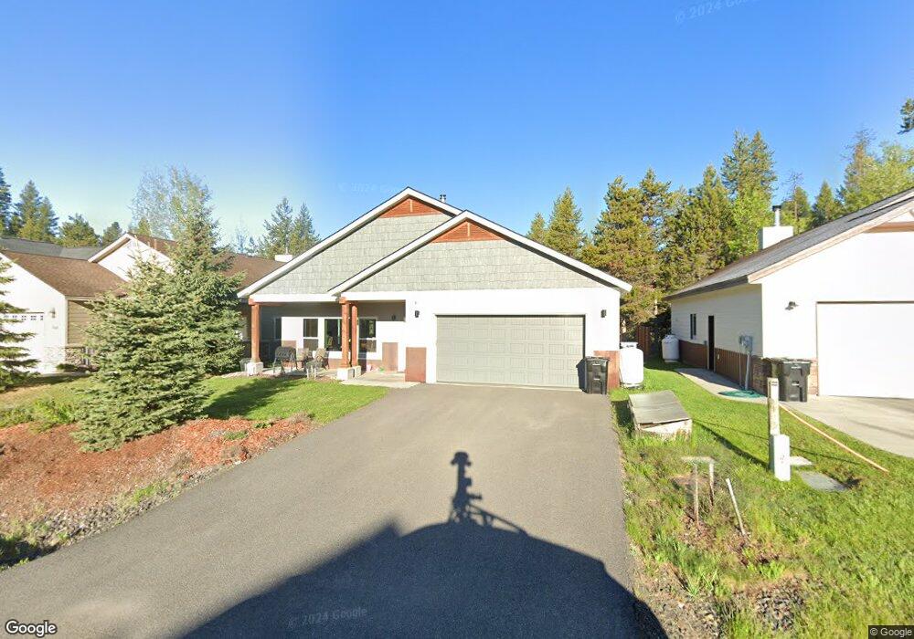
744 Deer Forest Dr McCall, ID 83638
Estimated Value: $714,605 - $887,000
3
Beds
2
Baths
1,533
Sq Ft
$517/Sq Ft
Est. Value
About This Home
This home is located at 744 Deer Forest Dr, McCall, ID 83638 and is currently estimated at $792,151, approximately $516 per square foot. 744 Deer Forest Dr is a home located in Valley County with nearby schools including McCall-Donnelly High School, Mountain Life Education, and The North Fork School.
Ownership History
Date
Name
Owned For
Owner Type
Purchase Details
Closed on
Mar 23, 2018
Sold by
Blank Michelle and Brun Alex
Bought by
Blank Michelle and Brun Alex
Current Estimated Value
Purchase Details
Closed on
Aug 24, 2017
Sold by
Benchmark Development Partnership Llc
Bought by
Blank Michelle and Brun Alex
Purchase Details
Closed on
Aug 17, 2017
Sold by
Deer Ltd
Bought by
Benchmark Development Partnership Llc
Create a Home Valuation Report for This Property
The Home Valuation Report is an in-depth analysis detailing your home's value as well as a comparison with similar homes in the area
Home Values in the Area
Average Home Value in this Area
Purchase History
| Date | Buyer | Sale Price | Title Company |
|---|---|---|---|
| Blank Michelle | -- | None Available | |
| Blank Michelle | -- | First American Title Mccall | |
| Benchmark Development Partnership Llc | -- | First American Title Mccall |
Source: Public Records
Tax History
| Year | Tax Paid | Tax Assessment Tax Assessment Total Assessment is a certain percentage of the fair market value that is determined by local assessors to be the total taxable value of land and additions on the property. | Land | Improvement |
|---|---|---|---|---|
| 2025 | $2,300 | $707,674 | $160,562 | $547,112 |
| 2023 | $2,300 | $719,142 | $152,534 | $566,608 |
| 2022 | $2,732 | $654,767 | $168,590 | $486,177 |
| 2021 | $2,558 | $452,074 | $61,037 | $391,037 |
| 2020 | $2,383 | $367,937 | $72,554 | $295,383 |
| 2019 | $2,417 | $349,211 | $72,554 | $276,657 |
| 2018 | $2,265 | $313,901 | $60,860 | $253,041 |
| 2017 | $129 | $51,860 | $51,860 | $0 |
| 2016 | $127 | $49,688 | $49,688 | $0 |
| 2015 | $123 | $11,617 | $0 | $0 |
| 2013 | -- | $10,102 | $0 | $0 |
Source: Public Records
Map
Nearby Homes
- 911 Davis Ave
- 615 Syringa Dr
- 707 Bridle Path Way
- 1085 Chip Shot Dr
- 1345 Divot Ln
- 1365 Divot Ln Unit 7
- 1365 Divot Ln
- 703 Wooley Ave
- 1329 Hearthstone Ct Unit 5A
- 1034 Fireweed Dr
- 1349 Hearthstone Ct Unit 9-G
- 1361 Hearthstone Ct Unit 12H
- 697 N Samson Trail Unit 7
- 699 N Samson Trail Unit 5
- 697 N Samson Trail
- 699 N Samson Trail
- 715 Spruce St
- 1389 Hearthstone Ct Unit 17-E
- 1391 Hearthstone Ct Unit 18-D
- 1008 Penstemen Place
- 748 Deer Forest Dr Unit 13
- 748 Deer Forest Dr
- 752 Deer Forest Dr
- 740 Deer Forest Dr
- 756 Deer Forest Dr Unit 15
- 756 Deer Forest Dr
- 739 Deer Forest Dr
- 749 Deer Forest Dr
- 745 Deer Forest Dr
- 755 Deer Forest Dr
- 736 Deer Forest Dr Unit 10
- 736 Deer Forest Dr
- 760 Deer Forest Dr
- 723 Deer Forest Dr
- 766 Deer Forest Dr
- 768 Deer Forest Dr
- TBD Deer Forest Dr
- TBD Deer Forest Dr Unit 9
- TBD Deer Forest Dr Unit 6
- TBD Deer Forest Dr Unit 7
Your Personal Tour Guide
Ask me questions while you tour the home.