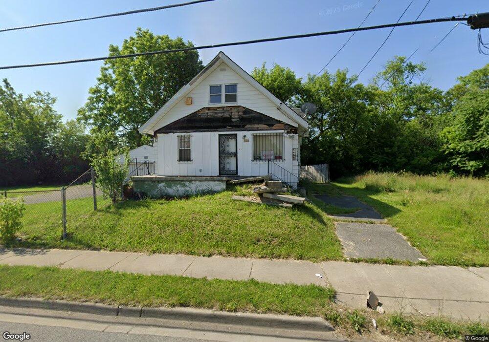
744 E Pierson Rd Flint, MI 48505
Northeast Village NeighborhoodEstimated Value: $35,000 - $57,000
4
Beds
1
Bath
1,036
Sq Ft
$47/Sq Ft
Est. Value
About This Home
This home is located at 744 E Pierson Rd, Flint, MI 48505 and is currently estimated at $49,087, approximately $47 per square foot. 744 E Pierson Rd is a home located in Genesee County with nearby schools including Brownell STEM Academy, The New Standard Academy, and Eagle's Nest Academy.
Ownership History
Date
Name
Owned For
Owner Type
Purchase Details
Closed on
Sep 11, 2019
Sold by
Genesee County Land Bank Authority
Bought by
Thomas Myran Lamont
Current Estimated Value
Purchase Details
Closed on
Mar 8, 2016
Sold by
The Genesee County Land Bank Authority
Bought by
Thomas Myran Lamont
Purchase Details
Closed on
Dec 17, 2015
Sold by
Genesee County
Bought by
Genesee County Land Bank
Purchase Details
Closed on
Aug 28, 2001
Sold by
Leverette Mark and Leverette Catrina
Bought by
Moore Brad D
Create a Home Valuation Report for This Property
The Home Valuation Report is an in-depth analysis detailing your home's value as well as a comparison with similar homes in the area
Home Values in the Area
Average Home Value in this Area
Purchase History
| Date | Buyer | Sale Price | Title Company |
|---|---|---|---|
| Thomas Myran Lamont | $3,300 | None Available | |
| Thomas Myran Lamont | $3,300 | None Available | |
| Genesee County Land Bank | -- | None Available | |
| Moore Brad D | $46,000 | -- |
Source: Public Records
Mortgage History
| Date | Status | Borrower | Loan Amount |
|---|---|---|---|
| Closed | Thomas Myran Lamont | $0 |
Source: Public Records
Tax History
| Year | Tax Paid | Tax Assessment Tax Assessment Total Assessment is a certain percentage of the fair market value that is determined by local assessors to be the total taxable value of land and additions on the property. | Land | Improvement |
|---|---|---|---|---|
| 2025 | $586 | $12,200 | $0 | $0 |
| 2024 | $545 | $10,200 | $0 | $0 |
| 2023 | $543 | $7,000 | $0 | $0 |
| 2022 | $0 | $5,700 | $0 | $0 |
| 2021 | $555 | $5,300 | $0 | $0 |
| 2020 | $540 | $6,000 | $0 | $0 |
| 2019 | $535 | $5,900 | $0 | $0 |
| 2018 | $732 | $5,900 | $0 | $0 |
| 2017 | $679 | $0 | $0 | $0 |
| 2016 | $221 | $0 | $0 | $0 |
| 2015 | -- | $0 | $0 | $0 |
| 2014 | -- | $0 | $0 | $0 |
| 2012 | -- | $6,700 | $0 | $0 |
Source: Public Records
Map
Nearby Homes
- 680 E Pierson Rd
- 618 E Parkway Ave
- 605 E Baltimore Blvd
- 350 E Mott Ave
- 802 E Russell Ave
- 4028 North St
- 345 E Austin Ave
- 225 E Piper Ave
- 638 E Foss Ave
- 418 E Foss Ave
- 425 E Lorado Ave
- 421 E Lorado Ave
- 1218 E Piper Ave
- 422 E Foss Ave
- 124 W Flint Park Blvd
- 426 E Holbrook Ave
- 329 W Baltimore Blvd
- 738 E York Ave
- 3810 Marvin St
- 902 Addison St
- 740 E Pierson Rd
- 741 Lomita Ave
- 745 Lomita Ave
- 743 E Pierson Rd
- 728 E Pierson Rd
- 764 E Pierson Rd
- 729 Lomita Ave
- 739 E Pierson Rd
- 735 E Pierson Rd
- 744 Lomita Ave
- 748 Lomita Ave
- 756 Lomita Ave
- 727 E Pierson Rd
- 719 Lomita Ave
- 760 Lomita Ave
- 772 E Pierson Rd
- 736 Lomita Ave
- 732 Lomita Ave
- 764 Lomita Ave
- 720 E Pierson Rd
Your Personal Tour Guide
Ask me questions while you tour the home.