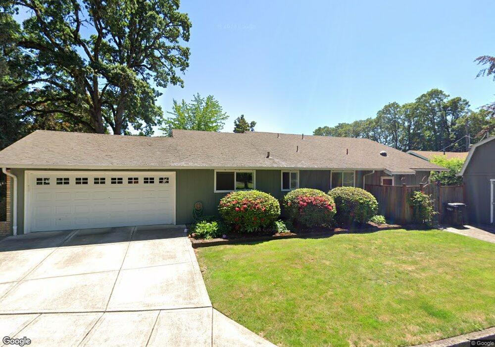
744 High St N Monmouth, OR 97361
Estimated Value: $469,000 - $507,000
3
Beds
3
Baths
2,184
Sq Ft
$225/Sq Ft
Est. Value
About This Home
This home is located at 744 High St N, Monmouth, OR 97361 and is currently estimated at $492,220, approximately $225 per square foot. 744 High St N is a home located in Polk County with nearby schools including Monmouth Elementary School, Talmadge Middle School, and Central High School.
Ownership History
Date
Name
Owned For
Owner Type
Purchase Details
Closed on
Sep 1, 2017
Sold by
Slauson Donna I and Glodt Donna I
Bought by
Cable Donna L and Cable Living Trust
Current Estimated Value
Home Financials for this Owner
Home Financials are based on the most recent Mortgage that was taken out on this home.
Interest Rate
3.82%
Purchase Details
Closed on
Jun 28, 2005
Sold by
Slauson Donna I
Bought by
Slauson Donna I and Slauson Revocable Living Trust
Create a Home Valuation Report for This Property
The Home Valuation Report is an in-depth analysis detailing your home's value as well as a comparison with similar homes in the area
Home Values in the Area
Average Home Value in this Area
Purchase History
| Date | Buyer | Sale Price | Title Company |
|---|---|---|---|
| Cable Donna L | $285,000 | -- | |
| Slauson Donna I | -- | -- |
Source: Public Records
Mortgage History
| Date | Status | Borrower | Loan Amount |
|---|---|---|---|
| Closed | Cable Donna L | -- |
Source: Public Records
Tax History Compared to Growth
Tax History
| Year | Tax Paid | Tax Assessment Tax Assessment Total Assessment is a certain percentage of the fair market value that is determined by local assessors to be the total taxable value of land and additions on the property. | Land | Improvement |
|---|---|---|---|---|
| 2025 | $4,328 | $260,910 | $74,750 | $186,160 |
| 2024 | $4,328 | $253,320 | $72,570 | $180,750 |
| 2023 | $4,507 | $245,950 | $70,450 | $175,500 |
| 2022 | $4,058 | $238,790 | $68,400 | $170,390 |
| 2021 | $4,011 | $231,840 | $66,410 | $165,430 |
| 2020 | $3,852 | $225,090 | $64,470 | $160,620 |
| 2019 | $3,740 | $218,540 | $62,600 | $155,940 |
| 2018 | $3,612 | $212,180 | $60,780 | $151,400 |
| 2017 | $3,592 | $206,000 | $59,010 | $146,990 |
| 2016 | $3,584 | $200,000 | $57,290 | $142,710 |
| 2015 | $3,412 | $193,230 | $54,000 | $139,230 |
| 2014 | $3,320 | $188,530 | $54,000 | $134,530 |
Source: Public Records
Map
Nearby Homes
- 751 Catron St N
- 555 High St N
- 0 Catron St N
- 1082 Alberta Ave E
- 858 Main St E
- 348 Main St E
- 191 Catron St S
- 1329 Price Ln E
- 9650 Hoffman Rd
- 271 Clay St E
- 309 Atwater St S
- 297 Main St W
- 360 Main St W
- 101 Edwards Rd S Unit 10-B Rd S
- 141 S 17th St Unit 61 St
- 141 S 17th St Unit 70 St
- 235 Edwards (#104) Rd S Unit 104
- 141 17th (#7) St S Unit 7
- 151 Edwards (#46) Rd S Unit 46
- 151 S Edwards (151) Rd