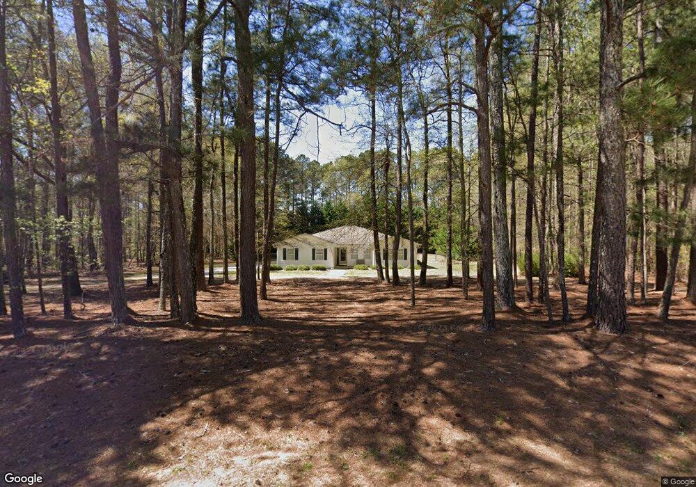
744 Old Forrester Rd Monroe, GA 30655
Estimated Value: $393,000 - $412,000
--
Bed
--
Bath
1,915
Sq Ft
$208/Sq Ft
Est. Value
About This Home
This home is located at 744 Old Forrester Rd, Monroe, GA 30655 and is currently estimated at $399,176, approximately $208 per square foot. 744 Old Forrester Rd is a home located in Walton County with nearby schools including Harmony Elementary School, Carver Middle School, and Monroe Area High School.
Ownership History
Date
Name
Owned For
Owner Type
Purchase Details
Closed on
Sep 3, 2011
Sold by
Thompson Vicki R
Bought by
Thompson Vicki R and Thompson Cody A
Current Estimated Value
Purchase Details
Closed on
Nov 19, 1998
Sold by
Thompson Greg A
Bought by
Thompson Vicki R
Purchase Details
Closed on
Jun 1, 1998
Sold by
Stuckey James D and Stuckey Terry W
Bought by
Thompson Greg A and Thompson Vicki R
Home Financials for this Owner
Home Financials are based on the most recent Mortgage that was taken out on this home.
Original Mortgage
$87,000
Interest Rate
7.15%
Mortgage Type
New Conventional
Purchase Details
Closed on
Feb 20, 1995
Sold by
Adcock Richard C Kathy B
Bought by
Stuckey James D Terry W
Purchase Details
Closed on
Jun 1, 1988
Bought by
Adcock Richard Charles
Create a Home Valuation Report for This Property
The Home Valuation Report is an in-depth analysis detailing your home's value as well as a comparison with similar homes in the area
Home Values in the Area
Average Home Value in this Area
Purchase History
| Date | Buyer | Sale Price | Title Company |
|---|---|---|---|
| Thompson Vicki R | -- | -- | |
| Thompson Vicki R | $10,000 | -- | |
| Thompson Greg A | $116,000 | -- | |
| Stuckey James D Terry W | $16,900 | -- | |
| Adcock Richard Charles | $17,500 | -- |
Source: Public Records
Mortgage History
| Date | Status | Borrower | Loan Amount |
|---|---|---|---|
| Previous Owner | Thompson Greg A | $87,000 |
Source: Public Records
Tax History Compared to Growth
Tax History
| Year | Tax Paid | Tax Assessment Tax Assessment Total Assessment is a certain percentage of the fair market value that is determined by local assessors to be the total taxable value of land and additions on the property. | Land | Improvement |
|---|---|---|---|---|
| 2024 | $668 | $127,400 | $35,280 | $92,120 |
| 2023 | $597 | $119,120 | $30,240 | $88,880 |
| 2022 | $563 | $110,600 | $27,080 | $83,520 |
| 2021 | $563 | $84,960 | $21,040 | $63,920 |
| 2020 | $576 | $77,160 | $18,240 | $58,920 |
| 2019 | $586 | $67,240 | $16,240 | $51,000 |
| 2018 | $586 | $67,240 | $16,240 | $51,000 |
| 2017 | $2,238 | $64,964 | $16,240 | $48,724 |
| 2016 | $1,802 | $56,416 | $11,560 | $44,856 |
| 2015 | $1,556 | $47,576 | $10,480 | $37,096 |
| 2014 | -- | $47,148 | $10,000 | $37,148 |
Source: Public Records
Map
Nearby Homes
- 710 Poplar St
- 725 Poplar St
- 592 Gene Bell Rd NE
- 574 Gene Bell Rd NE
- 490 Gene Bell Rd NE
- 1628 Brook Ln
- 1200 Magnolia Ridge
- 909 Pannell Rd
- 1042 Wheel House Ln Unit C
- 309 Magnolia Ln
- 838 Store House Ct Unit A
- 838 Store House Ct Unit C
- 607 Cantor Way
- Ashmore Plan at Brookland Commons
- Danbury Plan at Brookland Commons
- Denton TH Plan at Brookland Commons
- Avril Plan at Brookland Commons
- Ashton Plan at Brookland Commons
- Oakgrove Plan at Brookland Commons
- AnsonTH Plan at Brookland Commons
- 784 Old Forrester Rd
- 804 Poplar St
- 720 Poplar St
- 700 Poplar St
- 744 Poplar St
- 670 Poplar St
- 763 Old Forrester Rd
- 0 Old Forrester Rd
- 770 Stillbrook Dr
- 790 Stillbrook Dr
- 783 Old Forrester Rd
- 620 Poplar St
- 870 Stillbrook Dr
- 810 Stillbrook Dr
- 850 Stillbrook Dr
- 699 Poplar St
- 804 Old Forrester Rd
- 779 Stillbrook Dr
- 769 Stillbrook Dr
- 745 Poplar St