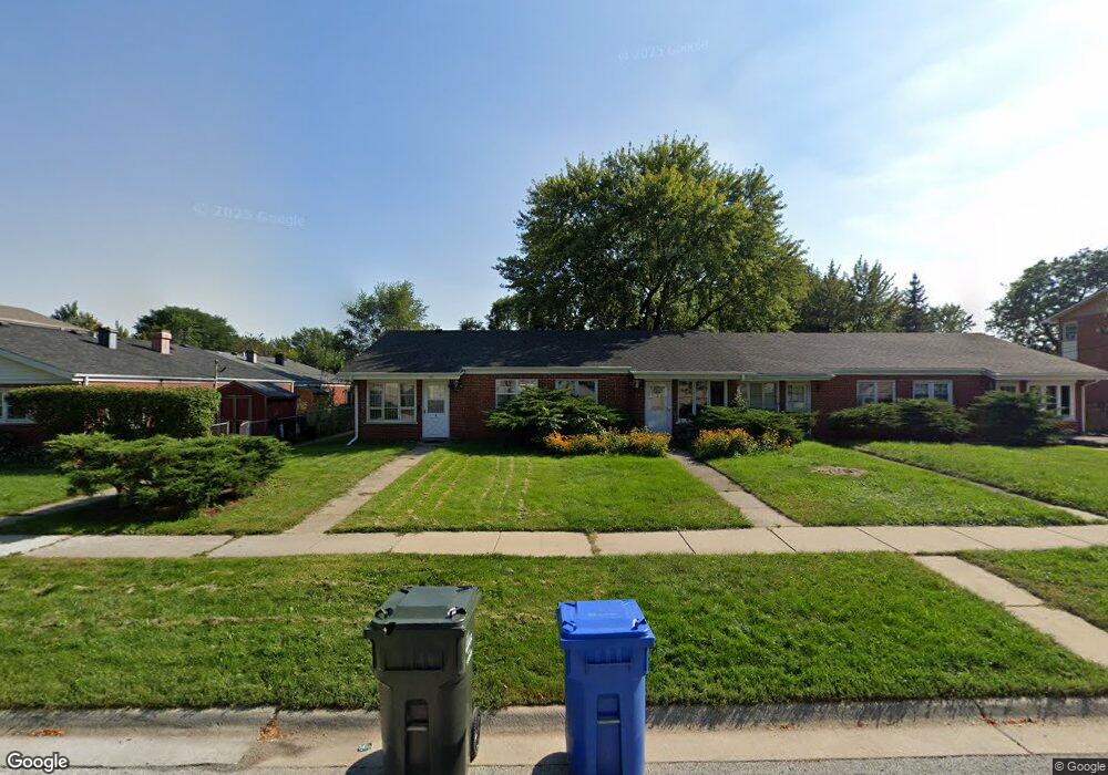
745 Dulles Rd Des Plaines, IL 60016
Estimated Value: $197,000 - $233,000
2
Beds
1
Bath
889
Sq Ft
$239/Sq Ft
Est. Value
About This Home
This home is located at 745 Dulles Rd, Des Plaines, IL 60016 and is currently estimated at $212,758, approximately $239 per square foot. 745 Dulles Rd is a home located in Cook County with nearby schools including Brentwood Elementary School, Friendship Jr High School, and Elk Grove High School.
Ownership History
Date
Name
Owned For
Owner Type
Purchase Details
Closed on
Mar 27, 2025
Sold by
Gatsios Nick E and Gatsios Nikolaos
Bought by
Nick E Gatsios Living Trust and Gatsios
Current Estimated Value
Purchase Details
Closed on
Jun 11, 2019
Sold by
Puhl Donald E
Bought by
Gatsios Evngelos and Gatsios Nikolaos
Purchase Details
Closed on
Jan 23, 2018
Sold by
Puhl Mary Jo
Bought by
Puhl Donald E and Donald E Puhl Living Trust
Purchase Details
Closed on
Nov 30, 2011
Sold by
Puhl Donald E
Bought by
Puhl Mary Jo and Mary Jo Puhl Revocable Living Trust #108
Create a Home Valuation Report for This Property
The Home Valuation Report is an in-depth analysis detailing your home's value as well as a comparison with similar homes in the area
Home Values in the Area
Average Home Value in this Area
Purchase History
| Date | Buyer | Sale Price | Title Company |
|---|---|---|---|
| Nick E Gatsios Living Trust | -- | None Listed On Document | |
| Gatsios Evngelos | $142,000 | Chicago Title | |
| Puhl Donald E | -- | None Available | |
| Puhl Mary Jo | -- | None Available |
Source: Public Records
Tax History
| Year | Tax Paid | Tax Assessment Tax Assessment Total Assessment is a certain percentage of the fair market value that is determined by local assessors to be the total taxable value of land and additions on the property. | Land | Improvement |
|---|---|---|---|---|
| 2025 | $4,505 | $22,001 | $11,996 | $10,005 |
| 2024 | $4,505 | $17,780 | $8,000 | $9,780 |
| 2023 | $5,209 | $17,780 | $8,000 | $9,780 |
| 2022 | $5,209 | $21,500 | $8,000 | $13,500 |
| 2021 | $3,370 | $12,128 | $3,022 | $9,106 |
| 2020 | $3,296 | $12,128 | $3,022 | $9,106 |
| 2019 | $3,332 | $13,476 | $3,022 | $10,454 |
| 2018 | $3,527 | $12,619 | $2,519 | $10,100 |
| 2017 | $3,462 | $12,619 | $2,519 | $10,100 |
| 2016 | $3,257 | $12,619 | $2,519 | $10,100 |
| 2015 | $3,317 | $12,036 | $2,267 | $9,769 |
| 2014 | $3,280 | $12,036 | $2,267 | $9,769 |
| 2013 | $3,210 | $12,036 | $2,267 | $9,769 |
Source: Public Records
Map
Nearby Homes
- 633 Dulles Rd Unit A
- 500 W Huntington Commons Rd Unit 448
- 756 W Millers Rd
- 1101 S Hunt Club Dr Unit 414
- 909 S Emerson St
- 380 Dulles Rd
- 901 S Can Dota Ave
- 381 W Millers Rd
- 1330 S Mallard Ln Unit 33
- 304 E Hiawatha Trail
- 407 E Berkshire Ln
- 703 W Manawa Trail
- 301 Lance Dr
- 930 Beau Dr Unit 313
- 170 Westmere Rd
- 650 Murray Ln Unit 214
- 650 Murray Ln Unit 314
- 960 Beau Dr Unit 109
- 507 S I Oka Ave
- 502 S I Oka Ave
- 745 Dulles Rd
- 745 Dulles Rd
- 745 Dulles Rd
- 745 Dulles Rd Unit A
- 737 Dulles Rd
- 737 Dulles Rd
- 737 Dulles Rd
- 737 Dulles Rd
- 737 Dulles Rd Unit D
- 737 Dulles Rd Unit C
- 755 Dulles Rd Unit F
- 755 Dulles Rd Unit B
- 755 Dulles Rd Unit C
- 755 Dulles Rd
- 755 Dulles Rd Unit A
- 755 Dulles Rd Unit D
- 732 Debra Dr
- 740 Debra Dr
- 733 Dulles Rd
- 724 Debra Dr
Your Personal Tour Guide
Ask me questions while you tour the home.