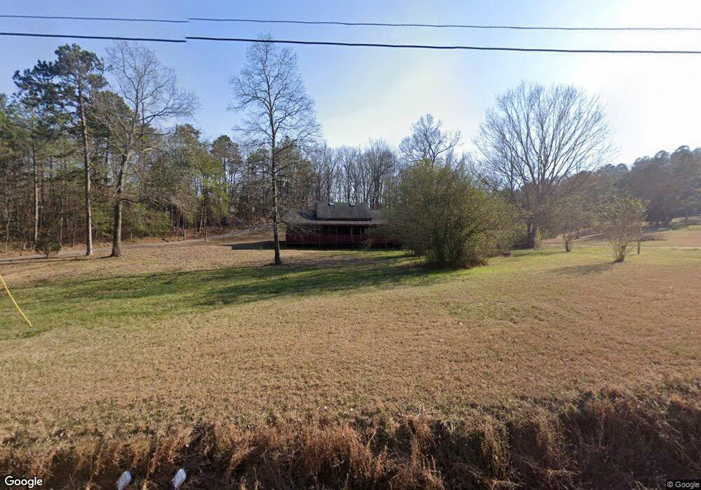
745 Woody Rd SW Adairsville, GA 30103
Estimated Value: $398,009 - $492,000
3
Beds
2
Baths
3,480
Sq Ft
$128/Sq Ft
Est. Value
About This Home
This home is located at 745 Woody Rd SW, Adairsville, GA 30103 and is currently estimated at $445,252, approximately $127 per square foot. 745 Woody Rd SW is a home located in Gordon County with nearby schools including Adairsville Elementary School, Adairsville Middle School, and Adairsville High School.
Ownership History
Date
Name
Owned For
Owner Type
Purchase Details
Closed on
Aug 26, 2003
Sold by
Smeed Elizabeth M and Smeed Louise S
Bought by
Farnes Glenda Lee and Petty Sherman J
Current Estimated Value
Purchase Details
Closed on
Dec 10, 2002
Sold by
Smeed Elizabeth M and Lucille Se
Bought by
Smeed Elizabeth M and Morgan Louise S
Purchase Details
Closed on
Jan 4, 2002
Sold by
Morgan Louise S and Smeed Elizabeth M
Bought by
Smeed Elizabeth M and Lucille Sexton
Create a Home Valuation Report for This Property
The Home Valuation Report is an in-depth analysis detailing your home's value as well as a comparison with similar homes in the area
Home Values in the Area
Average Home Value in this Area
Purchase History
| Date | Buyer | Sale Price | Title Company |
|---|---|---|---|
| Farnes Glenda Lee | $140,000 | -- | |
| Smeed Elizabeth M | -- | -- | |
| Smeed Elizabeth M | -- | -- |
Source: Public Records
Tax History Compared to Growth
Tax History
| Year | Tax Paid | Tax Assessment Tax Assessment Total Assessment is a certain percentage of the fair market value that is determined by local assessors to be the total taxable value of land and additions on the property. | Land | Improvement |
|---|---|---|---|---|
| 2024 | $2,812 | $112,688 | $9,240 | $103,448 |
| 2023 | $2,620 | $105,144 | $9,240 | $95,904 |
| 2022 | $2,609 | $98,592 | $9,240 | $89,352 |
| 2021 | $2,252 | $82,372 | $9,240 | $73,132 |
| 2020 | $2,280 | $81,588 | $9,240 | $72,348 |
| 2019 | $2,292 | $81,588 | $9,240 | $72,348 |
| 2018 | $2,118 | $75,520 | $9,240 | $66,280 |
| 2017 | $2,053 | $71,280 | $9,240 | $62,040 |
| 2016 | $2,058 | $71,280 | $9,240 | $62,040 |
| 2015 | $2,034 | $69,840 | $9,240 | $60,600 |
| 2014 | $1,929 | $68,256 | $9,242 | $59,014 |
Source: Public Records
Map
Nearby Homes
- 0 Woody Rd NW Unit 10634615
- 238 Lighthouse Cove SW
- 178 Harbor Trail
- 365 Riverboat Dr
- Woodridge Plan at The Landing at Miller’s Ferry
- Kensington Plan at The Landing at Miller’s Ferry
- Northwyck Plan at The Landing at Miller’s Ferry
- Richmond Plan at The Landing at Miller’s Ferry
- Brookhaven Plan at The Landing at Miller’s Ferry
- Newport I Plan at The Landing at Miller’s Ferry
- Wesley Plan at The Landing at Miller’s Ferry
- Newport II Plan at The Landing at Miller’s Ferry
- Richardson Plan at The Landing at Miller’s Ferry
- Dewhurst Plan at The Landing at Miller’s Ferry
- 269 Riverboat Dr
- 2857 McDaniel Station Rd SW
- 315 Woody Rd NW
- 50 Hopkins Farm Dr
- 51 Robin Rd
- 69 Hopkins Farm Dr
- 000 Woody Rd NW
- 0 Woody Rd NW
- 00 Woody Rd NW
- 0000 Woody Rd NW
- 0 Woody Rd NW Unit 7585247
- 0 Woody Rd NW Unit 10369719
- 0 Woody Rd NW Unit 7493024
- 0 Woody Rd NW Unit 7006610
- 0 Woody Rd NW Unit 3108536
- 0 Woody Rd NW Unit 7483235
- 0 Woody Rd NW Unit 7483135
- 0 Woody Rd NW Unit 7577357
- 0 Woody Rd NW Unit 3009411
- 0 Woody Rd NW Unit 8098592
- 0 Woody Rd NW Unit 8112735
- 0 Woody Rd NW Unit 6012 8279729
- 0 Woody Rd NW Unit 6013 8279730
- 0 Woody Rd NW Unit 5563946
- 0 Woody Rd NW Unit 6676807
- 0 Woody Rd NW Unit 7176539