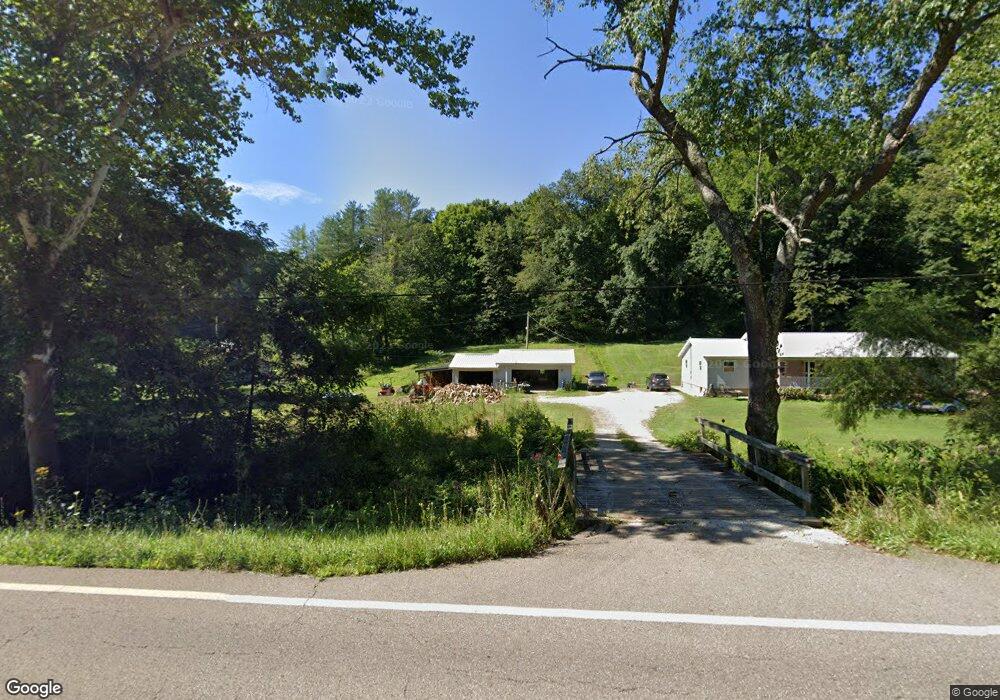
7453 State Route 78 Glouster, OH 45732
Estimated Value: $200,219 - $323,000
2
Beds
1
Bath
1,680
Sq Ft
$155/Sq Ft
Est. Value
About This Home
This home is located at 7453 State Route 78, Glouster, OH 45732 and is currently estimated at $261,055, approximately $155 per square foot. 7453 State Route 78 is a home located in Athens County with nearby schools including Trimble Elementary School, Trimble Middle School, and Trimble High School.
Ownership History
Date
Name
Owned For
Owner Type
Purchase Details
Closed on
Jun 8, 2022
Sold by
Hardy Andrew T and Hardy Kathleen
Bought by
Hardy Scott Thomas and Shamhart Stacey Kathleen
Current Estimated Value
Purchase Details
Closed on
Jun 1, 1992
Sold by
Hardy Andrew T
Bought by
Hardy Samuel D
Create a Home Valuation Report for This Property
The Home Valuation Report is an in-depth analysis detailing your home's value as well as a comparison with similar homes in the area
Home Values in the Area
Average Home Value in this Area
Purchase History
| Date | Buyer | Sale Price | Title Company |
|---|---|---|---|
| Hardy Scott Thomas | -- | None Listed On Document | |
| Hardy Samuel D | -- | -- |
Source: Public Records
Tax History Compared to Growth
Tax History
| Year | Tax Paid | Tax Assessment Tax Assessment Total Assessment is a certain percentage of the fair market value that is determined by local assessors to be the total taxable value of land and additions on the property. | Land | Improvement |
|---|---|---|---|---|
| 2024 | $2,886 | $45,030 | $7,280 | $37,750 |
| 2023 | $1,834 | $45,030 | $7,280 | $37,750 |
| 2022 | $1,167 | $36,270 | $6,070 | $30,200 |
| 2021 | $1,195 | $36,270 | $6,070 | $30,200 |
| 2020 | $1,196 | $36,270 | $6,070 | $30,200 |
| 2019 | $1,077 | $33,520 | $5,190 | $28,330 |
| 2018 | $1,189 | $33,520 | $5,190 | $28,330 |
| 2017 | $2,234 | $33,520 | $5,190 | $28,330 |
| 2016 | $1,085 | $31,460 | $4,720 | $26,740 |
| 2015 | $2,080 | $31,460 | $4,720 | $26,740 |
| 2014 | $2,080 | $31,460 | $4,720 | $26,740 |
| 2013 | $1,653 | $28,570 | $4,050 | $24,520 |
Source: Public Records
Map
Nearby Homes
- 13899 Locust St
- 45747 Long St
- 140 Sycamore St
- 31 Locust St
- 33 S High St
- 0 Greens Run Rd
- 10271 Antle Orchard Rd
- 93 Main St
- 88 Front St
- 19477 Center
- 19500 Lake Dr
- 0 Red Rock Rd
- 6 E Main St
- 0 Oregon Ridge Rd Unit 23564746
- 18242 Ohio 13
- 11789 Congress Run Rd
- 0 Marietta Ave
- 17795 N Akron Ave
- 44438 Carbon Hill Buchtel Rd
- 12141 Burton Hill Rd
- 7493 State Route 78
- 7434 Ohio 78
- 7434 State Route 78
- 7481 State Route 78
- 7535 State Route 78
- 7560 State Route 78
- 7650 State Route 78
- 7810 Ohio 78
- 8010 Hunterdon Rd
- 0 Hunterdon Rd Unit Pacel 15 2745454
- 0 Hunterdon Rd Unit 2100496
- 0 Hunterdon Rd Unit Parcel 15 2736969
- 0 Hunterdon Rd
- 6751 Hunterdon Rd
- 7975 State Route 78
- 8045 Hunterdon Rd
- 8057 Hunterdon Rd
- 8012 State Route 78
- 8062 Hunterdon Rd
- 8087 Hunterdon Rd