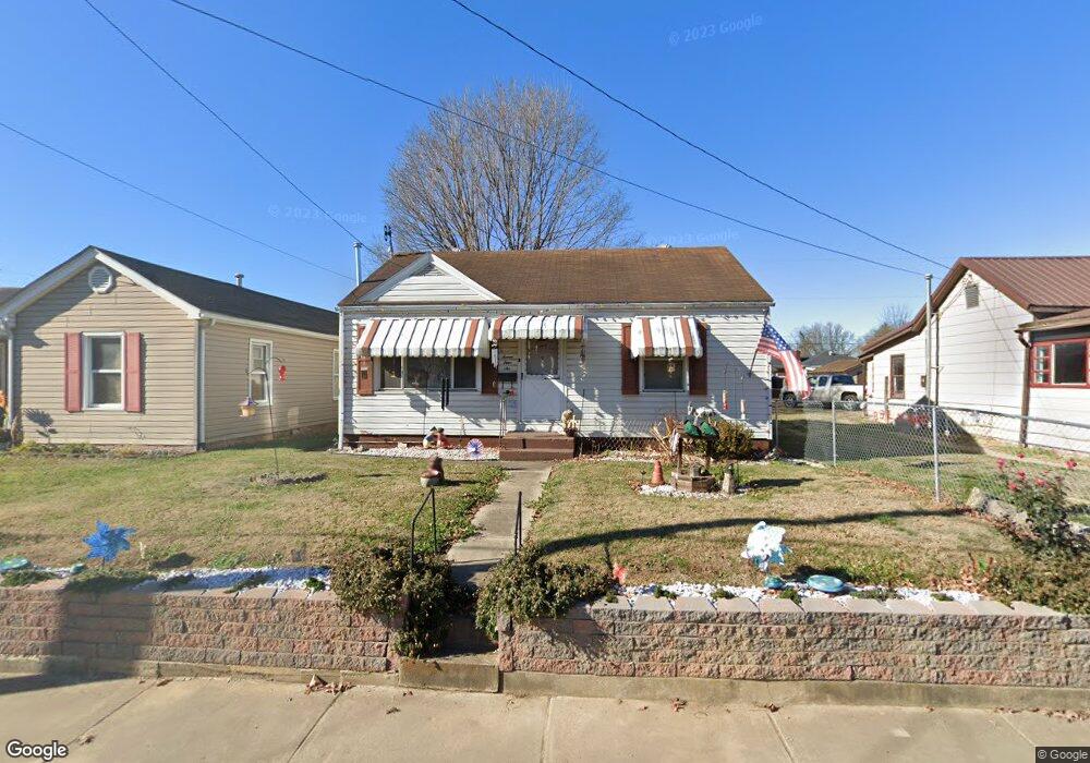
746 High St Coal Grove, OH 45638
Estimated Value: $84,695 - $102,000
2
Beds
1
Bath
832
Sq Ft
$109/Sq Ft
Est. Value
About This Home
This home is located at 746 High St, Coal Grove, OH 45638 and is currently estimated at $90,924, approximately $109 per square foot. 746 High St is a home located in Lawrence County with nearby schools including Dawson-Bryant Elementary School, Dawson-Bryant Middle School, and Dawson-Bryant High School.
Ownership History
Date
Name
Owned For
Owner Type
Purchase Details
Closed on
Oct 19, 2015
Sold by
Brooks Jerry L
Bought by
Brooks Jerry L and Brooks Vivian
Current Estimated Value
Purchase Details
Closed on
Mar 2, 2005
Sold by
Webb Paul Michael and Queen Linda
Bought by
Brooks Jerry L and Brooks Paula M
Home Financials for this Owner
Home Financials are based on the most recent Mortgage that was taken out on this home.
Original Mortgage
$61,750
Outstanding Balance
$30,589
Interest Rate
5.67%
Mortgage Type
New Conventional
Estimated Equity
$60,335
Create a Home Valuation Report for This Property
The Home Valuation Report is an in-depth analysis detailing your home's value as well as a comparison with similar homes in the area
Home Values in the Area
Average Home Value in this Area
Purchase History
| Date | Buyer | Sale Price | Title Company |
|---|---|---|---|
| Brooks Jerry L | -- | Attorney | |
| Brooks Jerry L | $61,800 | None Available |
Source: Public Records
Mortgage History
| Date | Status | Borrower | Loan Amount |
|---|---|---|---|
| Open | Brooks Jerry L | $61,750 |
Source: Public Records
Tax History
| Year | Tax Paid | Tax Assessment Tax Assessment Total Assessment is a certain percentage of the fair market value that is determined by local assessors to be the total taxable value of land and additions on the property. | Land | Improvement |
|---|---|---|---|---|
| 2025 | $368 | $22,348 | $5,121 | $17,227 |
| 2024 | -- | $21,890 | $4,660 | $17,230 |
| 2023 | $386 | $21,890 | $4,660 | $17,230 |
| 2022 | $396 | $21,890 | $4,660 | $17,230 |
| 2021 | $274 | $17,970 | $3,800 | $14,170 |
| 2020 | $290 | $17,970 | $3,800 | $14,170 |
| 2019 | $289 | $17,970 | $3,800 | $14,170 |
| 2018 | $244 | $16,340 | $3,460 | $12,880 |
| 2017 | $243 | $16,340 | $3,460 | $12,880 |
| 2016 | $223 | $16,340 | $3,460 | $12,880 |
| 2015 | $477 | $15,500 | $3,460 | $12,040 |
| 2014 | $440 | $15,500 | $3,460 | $12,040 |
| 2013 | $440 | $15,500 | $3,460 | $12,040 |
Source: Public Records
Map
Nearby Homes
- 514 Lane St
- 519 Lane St
- 805 1/2 High St
- 303 Pike St
- 103 Carrico Dr
- 1003 Marion Pike
- 2805 S 8th St
- 0 Central & Mlk
- 321 Wyanoke St
- 2725 S 5th St
- 1100 Price St
- 2620 S 13th St
- 2601 S 6th St
- 2531 S 8th St
- 508 16th St
- 115 Hillcrest Ct
- 2518 S 9th St
- 1400 Montgomery Ave
- 2520 S 6th St Unit BO-1
- 2444 S 10th St
Your Personal Tour Guide
Ask me questions while you tour the home.