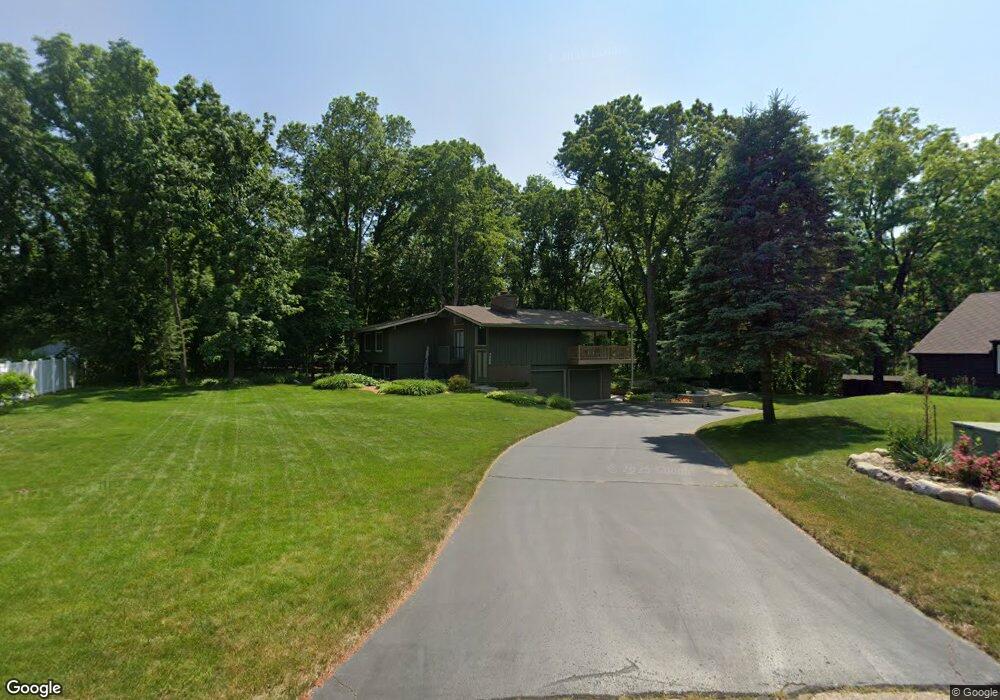
7466 Thrasher Ln Kalamazoo, MI 49009
Estimated Value: $356,770 - $423,000
3
Beds
3
Baths
1,769
Sq Ft
$221/Sq Ft
Est. Value
About This Home
This home is located at 7466 Thrasher Ln, Kalamazoo, MI 49009 and is currently estimated at $391,443, approximately $221 per square foot. 7466 Thrasher Ln is a home located in Kalamazoo County with nearby schools including 12th Street Elementary School, Portage West Middle School, and Portage Central High School.
Ownership History
Date
Name
Owned For
Owner Type
Purchase Details
Closed on
May 29, 2008
Sold by
Anderson Dewayne B and Anderson Janice P
Bought by
Anderson Dewayne B and Anderson Janice P
Current Estimated Value
Home Financials for this Owner
Home Financials are based on the most recent Mortgage that was taken out on this home.
Original Mortgage
$101,766
Interest Rate
6.01%
Mortgage Type
New Conventional
Create a Home Valuation Report for This Property
The Home Valuation Report is an in-depth analysis detailing your home's value as well as a comparison with similar homes in the area
Home Values in the Area
Average Home Value in this Area
Purchase History
We collect this data history from publicly available records. To have your information removed, we recommend requesting removal directly through your county’s website.
| Date | Buyer | Sale Price | Title Company |
|---|---|---|---|
| Anderson Dewayne B | -- | Chicago Title |
Source: Public Records
Mortgage History
We collect this data history from publicly available records. To have your information removed, we recommend requesting removal directly through your county’s website.
| Date | Status | Borrower | Loan Amount |
|---|---|---|---|
| Closed | Anderson Dewayne B | $101,766 |
Source: Public Records
Tax History
| Year | Tax Paid | Tax Assessment Tax Assessment Total Assessment is a certain percentage of the fair market value that is determined by local assessors to be the total taxable value of land and additions on the property. | Land | Improvement |
|---|---|---|---|---|
| 2025 | $1,306 | $157,400 | $0 | $0 |
| 2024 | $1,268 | $146,900 | $0 | $0 |
| 2023 | $1,209 | $133,700 | $0 | $0 |
| 2022 | $3,978 | $120,200 | $0 | $0 |
| 2021 | $3,866 | $113,100 | $0 | $0 |
| 2020 | $3,775 | $110,800 | $0 | $0 |
| 2019 | $3,448 | $109,300 | $0 | $0 |
| 2018 | $2,117 | $112,900 | $0 | $0 |
| 2017 | -- | $113,100 | $0 | $0 |
| 2016 | -- | $109,000 | $0 | $0 |
| 2015 | -- | $94,500 | $11,000 | $83,500 |
| 2014 | -- | $94,500 | $0 | $0 |
Source: Public Records
Map
Nearby Homes
- 5204 Foxcroft Dr
- 7702 Hunters Ridge Dr
- 5471 Gatwick Ct
- 5363 Four Seasons Dr
- 7117 Venice Dr
- 6035 S 12th St
- 5283 W Q Ave
- 5115 Queen Victoria Ln
- 5661 Attleberry Ave
- 5820 Boxthorn Trail
- 5304 Whippoorwill Dr
- 5680 Attleberry Ave
- 4280 Romence Rd
- 6787 Tiger Lily Dr Unit 55
- 5850 Dunwoody Ct
- 6845 Annandale Dr
- 5944 Gavin Ln
- 7679 Blackmar Cir Unit 11
- 5978 Boxthorn Trail
- 3602 Woodbridge Ln Unit 64
- 7440 Thrasher Ln
- 5132 Thrasher Ct
- 7482 Thrasher Ln
- 7504 Thrasher Ln
- 7433 Thrasher Ln
- 7426 Thrasher Ln
- 7528 Thrasher Ln
- 5140 Thrasher Ct
- 5186 Burning Tree Rd
- 7457 Thrasher Ln
- 5176 Burning Tree Rd
- 5196 Burning Tree Rd
- 7404 Thrasher Ln
- 7493 Thrasher Ln
- 7411 Thrasher Ln
- 5166 Burning Tree Rd
- 7515 Thrasher Ln
- 5175 Stoney Brook Rd
- 7475 Thrasher Ln
- 5151 Stoney Brook Rd
Your Personal Tour Guide
Ask me questions while you tour the home.