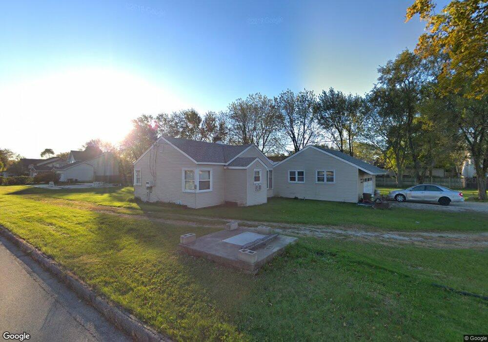
747 S Elmhurst Rd Wheeling, IL 60090
Estimated Value: $451,210 - $666,000
3
Beds
2
Baths
1,765
Sq Ft
$288/Sq Ft
Est. Value
About This Home
This home is located at 747 S Elmhurst Rd, Wheeling, IL 60090 and is currently estimated at $507,803, approximately $287 per square foot. 747 S Elmhurst Rd is a home located in Cook County with nearby schools including Mark Twain Elementary School, Oliver W Holmes Middle School, and Wheeling High School.
Ownership History
Date
Name
Owned For
Owner Type
Purchase Details
Closed on
Aug 19, 2019
Sold by
Kielar John C and Kielar Grace A
Bought by
Alpha Omega Asset Investments Llc
Current Estimated Value
Home Financials for this Owner
Home Financials are based on the most recent Mortgage that was taken out on this home.
Original Mortgage
$308,750
Interest Rate
5.13%
Mortgage Type
New Conventional
Purchase Details
Closed on
Jul 9, 2004
Sold by
Patecki Jacek and Patecki Dorota
Bought by
Kielar John C and Kielar Grace A
Purchase Details
Closed on
Feb 1, 1996
Sold by
Bard Kenneth and Bard Elizabeth
Bought by
Kielar John C and Kielar Grace A
Home Financials for this Owner
Home Financials are based on the most recent Mortgage that was taken out on this home.
Original Mortgage
$150,000
Interest Rate
7.16%
Create a Home Valuation Report for This Property
The Home Valuation Report is an in-depth analysis detailing your home's value as well as a comparison with similar homes in the area
Home Values in the Area
Average Home Value in this Area
Purchase History
| Date | Buyer | Sale Price | Title Company |
|---|---|---|---|
| Alpha Omega Asset Investments Llc | $350,000 | Fidelity National Title | |
| Kielar John C | $300,000 | Stewart Title Of Illinois | |
| Kielar John C | $285,000 | -- |
Source: Public Records
Mortgage History
| Date | Status | Borrower | Loan Amount |
|---|---|---|---|
| Previous Owner | Alpha Omega Asset Investments Llc | $308,750 | |
| Previous Owner | Kielar John C | $150,000 |
Source: Public Records
Tax History
| Year | Tax Paid | Tax Assessment Tax Assessment Total Assessment is a certain percentage of the fair market value that is determined by local assessors to be the total taxable value of land and additions on the property. | Land | Improvement |
|---|---|---|---|---|
| 2025 | $10,731 | $67,614 | $67,614 | -- |
| 2024 | $10,731 | $32,019 | $16,019 | $16,000 |
| 2023 | $10,234 | $32,019 | $16,019 | $16,000 |
| 2022 | $10,234 | $32,019 | $16,019 | $16,000 |
| 2021 | $10,340 | $27,907 | $10,402 | $17,505 |
| 2020 | $10,070 | $27,907 | $10,402 | $17,505 |
| 2019 | $10,206 | $31,147 | $10,402 | $20,745 |
| 2018 | $10,950 | $30,006 | $9,101 | $20,905 |
| 2017 | $10,727 | $30,006 | $9,101 | $20,905 |
| 2016 | $10,011 | $30,006 | $9,101 | $20,905 |
| 2015 | $9,515 | $26,703 | $7,801 | $18,902 |
| 2014 | $9,282 | $26,703 | $7,801 | $18,902 |
| 2013 | $8,569 | $26,703 | $7,801 | $18,902 |
Source: Public Records
Map
Nearby Homes
- 651 Garth Rd
- 751 Garth Rd
- 1105 N Maple Ln
- 492 Bernice Ct
- 475 E Merle Ln
- 353 E Norman Ln
- 1111 Pleasant Run Dr Unit 911
- 988 Ridgefield Ln Unit 54
- 1125 Pleasant Run Dr Unit 807
- 200 Violet Ln
- 1201 Pleasant Run Dr Unit 312
- 665 Cindy Ln
- 231 E Wayne Place
- 2812 Jackson Dr
- 2822 Jackson Dr
- 3026 Jackson Dr
- 709 Lakeside Circle Dr Unit 2
- 523 Bridle Trail Unit 161
- 448 Bridle Trail Unit 211
- 791 Lakeside Circle Dr Unit 1
Your Personal Tour Guide
Ask me questions while you tour the home.