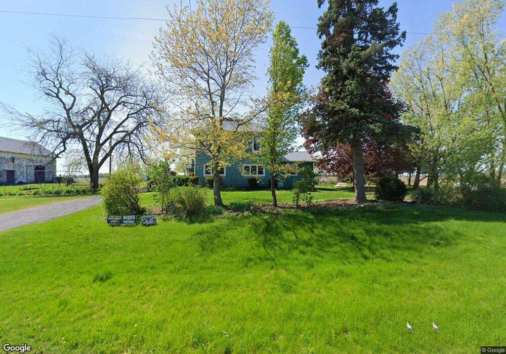
7473 Bryant Rd Morenci, MI 49256
Estimated Value: $204,000 - $236,828
5
Beds
1
Bath
1,929
Sq Ft
$113/Sq Ft
Est. Value
About This Home
This home is located at 7473 Bryant Rd, Morenci, MI 49256 and is currently estimated at $217,609, approximately $112 per square foot. 7473 Bryant Rd is a home located in Lenawee County with nearby schools including Morenci Elementary School and Morenci Middle/High School.
Ownership History
Date
Name
Owned For
Owner Type
Purchase Details
Closed on
Oct 29, 2007
Sold by
Gamble Tina
Bought by
Meckley David E and Meckley Rachel
Current Estimated Value
Home Financials for this Owner
Home Financials are based on the most recent Mortgage that was taken out on this home.
Original Mortgage
$110,000
Outstanding Balance
$69,813
Interest Rate
6.44%
Mortgage Type
New Conventional
Estimated Equity
$147,796
Purchase Details
Closed on
Oct 10, 2007
Sold by
Baldwin Clarke F
Bought by
Estate Jason Eric Green
Home Financials for this Owner
Home Financials are based on the most recent Mortgage that was taken out on this home.
Original Mortgage
$110,000
Outstanding Balance
$69,813
Interest Rate
6.44%
Mortgage Type
New Conventional
Estimated Equity
$147,796
Create a Home Valuation Report for This Property
The Home Valuation Report is an in-depth analysis detailing your home's value as well as a comparison with similar homes in the area
Home Values in the Area
Average Home Value in this Area
Purchase History
| Date | Buyer | Sale Price | Title Company |
|---|---|---|---|
| Meckley David E | $110,000 | Atcl | |
| Estate Jason Eric Green | -- | None Available | |
| Estate Of Octa May Green | -- | None Available |
Source: Public Records
Mortgage History
| Date | Status | Borrower | Loan Amount |
|---|---|---|---|
| Open | Meckley David E | $110,000 |
Source: Public Records
Tax History Compared to Growth
Tax History
| Year | Tax Paid | Tax Assessment Tax Assessment Total Assessment is a certain percentage of the fair market value that is determined by local assessors to be the total taxable value of land and additions on the property. | Land | Improvement |
|---|---|---|---|---|
| 2025 | $2,183 | $84,700 | $0 | $0 |
| 2024 | $746 | $84,600 | $0 | $0 |
| 2022 | $655 | $70,200 | $0 | $0 |
| 2021 | $1,928 | $60,600 | $0 | $0 |
| 2020 | $1,896 | $57,600 | $0 | $0 |
| 2019 | $165,797 | $54,300 | $0 | $0 |
| 2018 | $1,821 | $54,322 | $0 | $0 |
| 2017 | $1,753 | $52,685 | $0 | $0 |
| 2016 | $1,880 | $61,486 | $0 | $0 |
| 2014 | -- | $56,045 | $0 | $0 |
Source: Public Records
Map
Nearby Homes
- 8058 Packard Rd
- 8288 Packard Rd
- 9088 Elliott Hwy
- 6000 Tomer Rd
- 7925 Morey Hwy
- 8890 W Carleton Rd
- 9024 W Carleton Rd
- 7540 W Weston Rd
- 4113 Seneca St
- 4084 Seneca St
- 10554 Hickory St
- 2781 Benner Hwy
- 5101 Sand Creek Hwy
- 3601 Seneca St
- 10913 E Railroad St
- 4790 W Cadmus Rd
- 11609 Carleton Rd
- 10957 N Church St
- 9497 W Beecher Rd
- 1577 Benner Hwy
- 7325 Bryant Rd
- 7243 Bryant Rd
- 7231 Bryant Rd
- 7185 Bryant Rd
- 7185 Bryant Rd Unit BLK
- 7185 Bryant Rd Unit BRYANT RD
- 7153 Bryant Rd
- 7025 Bryant Rd
- 7405 Seneca Hwy
- 7273 Seneca Hwy
- 7348 Seneca Hwy
- 7407 Tuttle Hwy
- 7426 Tuttle Hwy
- 7518 Seneca Hwy
- 7438 Tuttle Hwy
- 7458 Tuttle Hwy
- 7034 Tuttle Hwy
- 7630 Seneca Hwy
- 7250 Tuttle Hwy
- 6856 Bryant Rd