C
Seller's Agent in 2025
Chirag Thakkar
Seed Realty LLC
(847) 529-3804
8 in this area
60 Total Sales
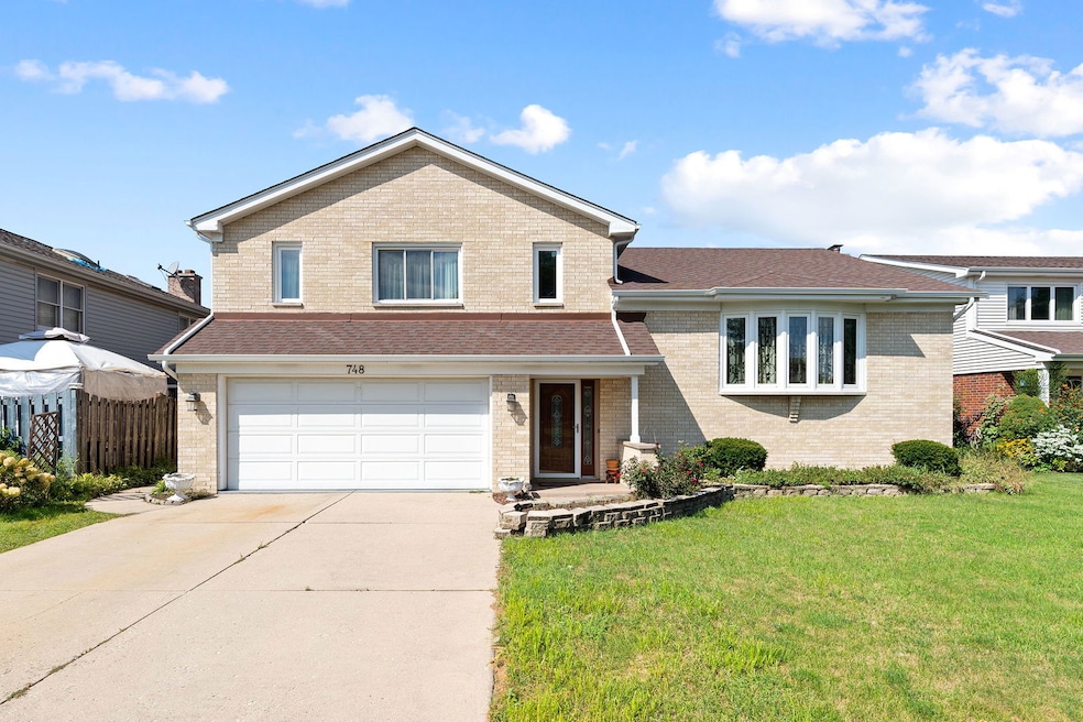


Welcome to 748 Yorkshire Lane! This beautifully cared-for home is perfect for families or anyone craving comfort and style. From the moment you walk in, you'll love the soaring vaulted ceilings, cozy fireplace, and gleaming hardwood floors that make the main living areas warm and inviting. Step outside to enjoy a spacious 7,200 sq ft lot, ideal for summer gatherings, gardening, or simply relaxing in your own backyard retreat. With an attached garage, central heating/cooling, and a smart, functional layout, this home checks every box. Nestled in one of Des Plaines' most desirable neighborhoods, you'll enjoy the perfect balance of convenience, charm, and community. Don't wait, homes like this move fast!! Schedule your showing today and make it yours!
Last Agent to Sell the Property
Seed Realty LLC License #471021860 Listed on: 09/09/2025
| Date | Type | Sale Price | Title Company |
|---|---|---|---|
| Deed | $540,500 | First American Title | |
| Quit Claim Deed | -- | None Listed On Document |
| Date | Status | Loan Amount | Loan Type |
|---|---|---|---|
| Open | $486,450 | New Conventional |
| Date | Event | Price | List to Sale | Price per Sq Ft |
|---|---|---|---|---|
| 11/05/2025 11/05/25 | Sold | $540,500 | +3.9% | $185 / Sq Ft |
| 10/07/2025 10/07/25 | Pending | -- | -- | -- |
| 09/09/2025 09/09/25 | For Sale | $520,000 | -- | $178 / Sq Ft |
| Year | Tax Paid | Tax Assessment Tax Assessment Total Assessment is a certain percentage of the fair market value that is determined by local assessors to be the total taxable value of land and additions on the property. | Land | Improvement |
|---|---|---|---|---|
| 2025 | $9,764 | $51,000 | $8,640 | $42,360 |
| 2024 | $9,764 | $43,000 | $7,200 | $35,800 |
| 2023 | $9,480 | $43,000 | $7,200 | $35,800 |
| 2022 | $9,480 | $43,000 | $7,200 | $35,800 |
| 2021 | $9,267 | $36,141 | $5,580 | $30,561 |
| 2020 | $9,234 | $36,141 | $5,580 | $30,561 |
| 2019 | $9,146 | $40,157 | $5,580 | $34,577 |
| 2018 | $8,763 | $35,485 | $4,860 | $30,625 |
| 2017 | $9,433 | $35,485 | $4,860 | $30,625 |
| 2016 | $9,167 | $35,485 | $4,860 | $30,625 |
| 2015 | $8,900 | $32,062 | $4,140 | $27,922 |
| 2014 | $8,728 | $32,062 | $4,140 | $27,922 |
| 2013 | $8,493 | $32,062 | $4,140 | $27,922 |
C
Seller's Agent in 2025
Chirag Thakkar
Seed Realty LLC
(847) 529-3804
8 in this area
60 Total Sales
G
Buyer's Agent in 2025
Gabrielle Burja-Varga
Pro-Via Realty Corp.
(773) 968-4551
6 in this area
77 Total Sales
Source: Midwest Real Estate Data (MRED)
MLS Number: 12462369
APN: 09-07-225-002-0000
Disclaimer: Certain information contained herein is derived from information provided by parties other than Homes.com. All information provided is deemed reliable, but is not guaranteed to be accurate and should be independently verified.
![]() Based on information submitted to the MLS GRID. All data is obtained from various sources and may not have been verified by broker or MLS GRID. Supplied Open House Information is subject to change without notice. All information should be independently reviewed and verified for accuracy. Properties may or may not be listed by the office/agent presenting the information. Some IDX listings have been excluded from this website.
Based on information submitted to the MLS GRID. All data is obtained from various sources and may not have been verified by broker or MLS GRID. Supplied Open House Information is subject to change without notice. All information should be independently reviewed and verified for accuracy. Properties may or may not be listed by the office/agent presenting the information. Some IDX listings have been excluded from this website.
Based on information submitted to the MLS GRID
Ask me questions while you tour the home.
