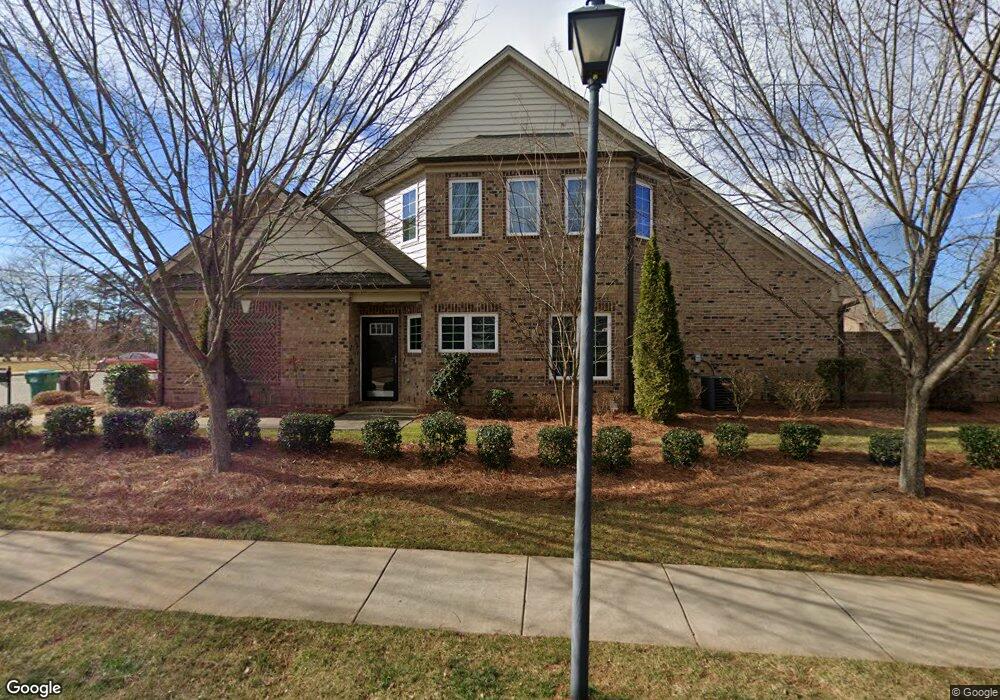
749 Common Dr High Point, NC 27265
Bent Tree NeighborhoodEstimated Value: $343,000 - $383,321
3
Beds
3
Baths
2,026
Sq Ft
$180/Sq Ft
Est. Value
About This Home
This home is located at 749 Common Dr, High Point, NC 27265 and is currently estimated at $365,080, approximately $180 per square foot. 749 Common Dr is a home with nearby schools including Southwest Elementary School, Southwest Guilford Middle School, and Southwest Guilford High School.
Ownership History
Date
Name
Owned For
Owner Type
Purchase Details
Closed on
Dec 18, 2015
Sold by
Keystone Group Inc
Bought by
Aumen Roberta A
Current Estimated Value
Home Financials for this Owner
Home Financials are based on the most recent Mortgage that was taken out on this home.
Original Mortgage
$178,740
Outstanding Balance
$141,541
Interest Rate
3.91%
Mortgage Type
New Conventional
Estimated Equity
$223,539
Purchase Details
Closed on
Dec 21, 2012
Bought by
Keystone Group Inc
Create a Home Valuation Report for This Property
The Home Valuation Report is an in-depth analysis detailing your home's value as well as a comparison with similar homes in the area
Home Values in the Area
Average Home Value in this Area
Purchase History
| Date | Buyer | Sale Price | Title Company |
|---|---|---|---|
| Aumen Roberta A | $223,500 | None Available | |
| Keystone Group Inc | -- | -- |
Source: Public Records
Mortgage History
| Date | Status | Borrower | Loan Amount |
|---|---|---|---|
| Open | Aumen Roberta A | $178,740 |
Source: Public Records
Tax History
| Year | Tax Paid | Tax Assessment Tax Assessment Total Assessment is a certain percentage of the fair market value that is determined by local assessors to be the total taxable value of land and additions on the property. | Land | Improvement |
|---|---|---|---|---|
| 2025 | $4,255 | $308,800 | $76,700 | $232,100 |
| 2024 | $4,255 | $308,800 | $76,700 | $232,100 |
| 2023 | $4,255 | $308,800 | $76,700 | $232,100 |
| 2022 | $4,163 | $308,800 | $76,700 | $232,100 |
| 2021 | $3,066 | $222,500 | $39,900 | $182,600 |
| 2020 | $3,066 | $222,500 | $39,900 | $182,600 |
| 2019 | $3,066 | $222,500 | $0 | $0 |
| 2018 | $3,051 | $222,500 | $0 | $0 |
| 2017 | $3,066 | $222,500 | $0 | $0 |
| 2016 | $2,665 | $190,000 | $0 | $0 |
Source: Public Records
Map
Nearby Homes
- 748 Carneros Cir
- 770 King Fisher Ln
- 715 Piedmont Crossing Dr Unit 14
- 4413 Edbury Ct
- 4716 Willowstone Dr
- 4722 Willowstone Dr
- 4714 Willowstone Dr
- 4712 Willowstone Dr
- 4710 Willowstone Dr
- 4715 Willowstone Dr
- 4713 Willowstone Dr
- 4711 Willowstone Dr
- 4723 Willowstone Dr
- 4725 Willowstone Dr
- 4743 Willowstone Dr
- 3477 Lilliefield Ln
- 1351 Grant Haven Ct
- 4630 White Beard Rd
- 3273 Alyssa Way
- 3740 Cottesmore Dr
- 747 Common Dr
- 745 Common Dr
- 743 Common Dr
- 761 King Fisher Ln
- 750 Carneros Cir Unit Lot 56
- 750 Carneros Cir
- 763 King Fisher Ln
- 740 Carneros Cir
- 754 Carneros Cir
- 736 Carneros Cir
- 765 King Fisher Ln Unit Lot 178
- 765 King Fisher Ln
- 4503 Barrow Rd
- 738 Carneros Cir
- 767 King Fisher Ln
- 752 King Fisher Ln Unit Lot 175
- 752 King Fisher Ln
- 742 Carneros Cir
- 752 Carneros Cir Unit Lot 57
- 752 Carneros Cir
Your Personal Tour Guide
Ask me questions while you tour the home.