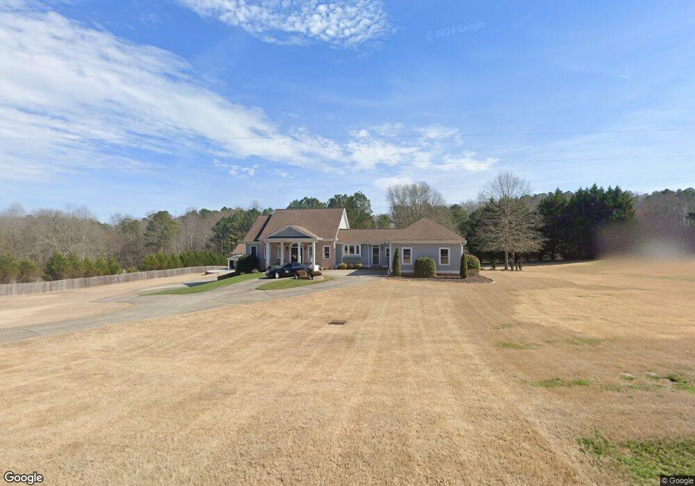
7490 McBrayer Rd Cumming, GA 30028
Estimated Value: $691,000 - $796,052
3
Beds
4
Baths
3,086
Sq Ft
$241/Sq Ft
Est. Value
About This Home
This home is located at 7490 McBrayer Rd, Cumming, GA 30028 and is currently estimated at $743,526, approximately $240 per square foot. 7490 McBrayer Rd is a home located in Forsyth County with nearby schools including Matt Elementary School, Liberty Middle School, and North Forsyth High School.
Ownership History
Date
Name
Owned For
Owner Type
Purchase Details
Closed on
Oct 27, 2025
Sold by
White Alice Dix
Bought by
Alice Dix White Revocable Living Trust and Sewards
Current Estimated Value
Purchase Details
Closed on
Aug 12, 2022
Sold by
Thomas Between Keith W
Bought by
Thomas Carolyn A and Thomas Keith W
Purchase Details
Closed on
Oct 29, 2018
Sold by
Thomas Keith W
Bought by
Thomas Kimberly D
Home Financials for this Owner
Home Financials are based on the most recent Mortgage that was taken out on this home.
Original Mortgage
$223,150
Interest Rate
4.7%
Mortgage Type
New Conventional
Purchase Details
Closed on
Mar 11, 2005
Sold by
Derham Dale R
Bought by
Thomas Keith W and Thomas Kimberly
Create a Home Valuation Report for This Property
The Home Valuation Report is an in-depth analysis detailing your home's value as well as a comparison with similar homes in the area
Home Values in the Area
Average Home Value in this Area
Purchase History
| Date | Buyer | Sale Price | Title Company |
|---|---|---|---|
| Alice Dix White Revocable Living Trust | -- | None Listed On Document | |
| Thomas Carolyn A | -- | Pc Law Associates | |
| Thomas Kimberly D | -- | -- | |
| Thomas Keith W | -- | -- |
Source: Public Records
Mortgage History
| Date | Status | Borrower | Loan Amount |
|---|---|---|---|
| Previous Owner | Thomas Kimberly D | $223,150 |
Source: Public Records
Tax History
| Year | Tax Paid | Tax Assessment Tax Assessment Total Assessment is a certain percentage of the fair market value that is determined by local assessors to be the total taxable value of land and additions on the property. | Land | Improvement |
|---|---|---|---|---|
| 2025 | $1,659 | $378,972 | $89,452 | $289,520 |
| 2024 | $1,659 | $349,228 | $67,088 | $282,140 |
| 2023 | $1,572 | $336,272 | $72,248 | $264,024 |
| 2022 | $6,227 | $216,720 | $49,740 | $166,980 |
| 2021 | $5,536 | $216,720 | $49,740 | $166,980 |
| 2020 | $5,365 | $208,420 | $49,740 | $158,680 |
| 2019 | $5,123 | $196,344 | $38,688 | $157,656 |
| 2018 | $5,736 | $230,440 | $38,688 | $191,752 |
| 2017 | $4,792 | $184,668 | $35,000 | $149,668 |
| 2016 | $4,636 | $177,300 | $27,632 | $149,668 |
| 2015 | $4,645 | $177,300 | $27,632 | $149,668 |
| 2014 | $4,081 | $160,848 | $0 | $0 |
Source: Public Records
Map
Nearby Homes
- 7925 Brewton Creek Dr
- 7655 Farrow Pass Cir
- 7925 Tiberon Pkwy
- 7525 Homer Dr
- 7515 Woolf Way
- 7140 Hunters Trace Dr
- 00 Wallace Tatum Rd
- 7650 Homer Dr
- 8425 River Hill Commons Dr
- 8440 River Bluff Place
- 8455 River Bluff Place
- 8515 River Hill Commons Dr
- 4195 Mossy Ln
- 0 Cox Rd Unit 10639616
- 0 Cox Rd Unit 25475533
- 8085 River Chase Dr
- 8145 Stone Hill Dr
- 8155 Stone Hill Dr
- 00001 Matt Hwy
- 3815 Pleasant Woods Dr
- 7480 McBrayer Rd
- 7530 McBrayer Rd
- 7410 McBrayer Rd
- 7440 McBrayer Rd
- 7320 Hightower Cir
- 7446 McBrayer Rd
- 7315 Hightower Cir
- 7345 Matt Hwy
- 7355 Hightower Cir
- 7350 Hightower Cir
- 7170 Matt Hwy
- 7360 Matt Hwy
- 7395 Hightower Cir
- 7345 McBrayer Rd
- 7335 McBrayer Rd
- 7405 Hightower Cir
- 7280 McBrayer Rd
- 0 Hightower Cir Unit 3 7513234
- 0 Hightower Cir Unit 3 7512941
- 0 Hightower Cir
Your Personal Tour Guide
Ask me questions while you tour the home.