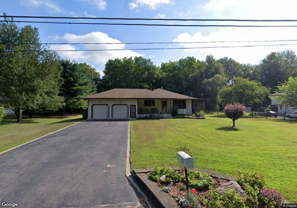
75 10th St Marlton, NJ 08053
Estimated Value: $411,454 - $436,000
2
Beds
2
Baths
1,248
Sq Ft
$338/Sq Ft
Est. Value
About This Home
This home is located at 75 10th St, Marlton, NJ 08053 and is currently estimated at $422,364, approximately $338 per square foot. 75 10th St is a home located in Burlington County with nearby schools including Robert B. Jaggard School, Marlton Middle School, and Cherokee High School.
Ownership History
Date
Name
Owned For
Owner Type
Purchase Details
Closed on
Dec 29, 2017
Sold by
Mannino Helen
Bought by
Hart Renee M
Current Estimated Value
Purchase Details
Closed on
Mar 25, 2010
Sold by
Franz Michael J and Franz Gina E
Bought by
Mannino David and Mannino Helen
Purchase Details
Closed on
Dec 14, 1999
Sold by
Nacucchio Carmela and Nacucchio Joanne P
Bought by
Nacucchio John F
Create a Home Valuation Report for This Property
The Home Valuation Report is an in-depth analysis detailing your home's value as well as a comparison with similar homes in the area
Home Values in the Area
Average Home Value in this Area
Purchase History
| Date | Buyer | Sale Price | Title Company |
|---|---|---|---|
| Hart Renee M | $215,000 | None Available | |
| Mannino David | $220,000 | Surety Title Corp | |
| Nacucchio John F | -- | -- |
Source: Public Records
Tax History Compared to Growth
Tax History
| Year | Tax Paid | Tax Assessment Tax Assessment Total Assessment is a certain percentage of the fair market value that is determined by local assessors to be the total taxable value of land and additions on the property. | Land | Improvement |
|---|---|---|---|---|
| 2025 | $7,626 | $223,300 | $95,800 | $127,500 |
| 2024 | $7,175 | $223,300 | $95,800 | $127,500 |
| 2023 | $7,175 | $223,300 | $95,800 | $127,500 |
| 2022 | $6,853 | $223,300 | $95,800 | $127,500 |
| 2021 | $6,692 | $223,300 | $95,800 | $127,500 |
| 2020 | $6,605 | $223,300 | $95,800 | $127,500 |
| 2019 | $6,552 | $223,300 | $95,800 | $127,500 |
| 2018 | $6,460 | $223,300 | $95,800 | $127,500 |
| 2017 | $6,134 | $223,300 | $95,800 | $127,500 |
| 2016 | $5,978 | $223,300 | $95,800 | $127,500 |
| 2015 | $5,868 | $223,300 | $95,800 | $127,500 |
| 2014 | $5,694 | $223,300 | $95,800 | $127,500 |
Source: Public Records
Map
Nearby Homes
- 57 9th St
- 55 9th St
- 108 Quail Rd
- 404 Quail Rd Unit 404
- 1315 Marlton Pike
- 1108 Squirrel Rd Unit 1108
- 34 3rd St
- 32 3rd St
- 34 3rd St
- 3808 Buxmont Rd Unit 3808
- 6205 Baltimore Dr Unit 6205
- 24 Carter Ln
- 108 Weaver Dr
- 53 Lowell Dr
- 61 Autumn Park Dr
- 29 Longhurst Rd
- 6 Bluff Ct
- 59 Eddy Way
- 10 Bayau Trail
- 32 Carlton Ave
- 2000 Roosevelt Ave
- 2100 Roosevelt Ave
- 81 10th St
- 85 10th St
- 10 10th St
- 65 10th St
- 76 10th St
- 82 10th St
- 2000 Old Marlton Pike E
- 2100 Old Marlton Pike E
- 1920 Old Marlton Pike E
- 2100 Marlton Pike
- 1920 Marlton Pike
- 1900 Marlton Pike
- 1900 Old Marlton Pike E
- 92 10th St
- 93 10th St
- 1841 Jefferson Ave
- 56 9th St
- 1820 Jefferson Ave