
Seller's Agent in 2025
Sarah Peters
EXP Realty, LLC
(484) 459-9944
52 in this area
215 Total Sales
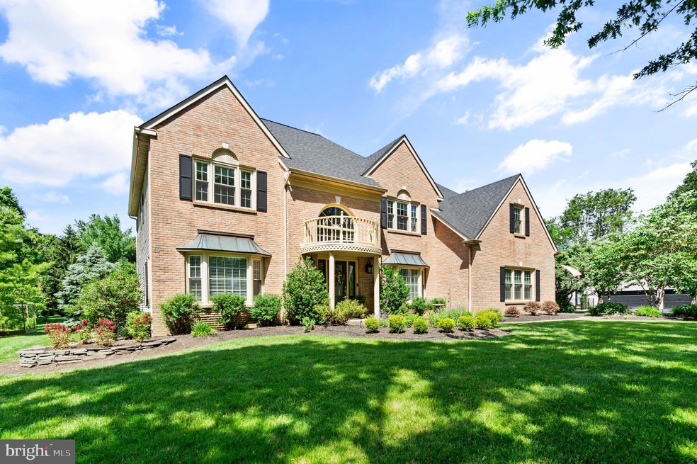
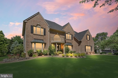
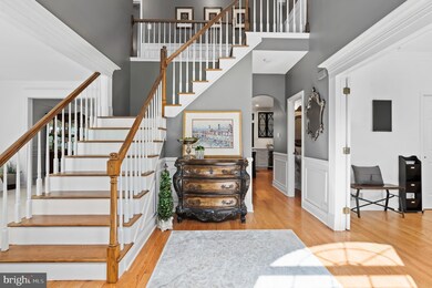
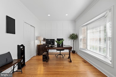
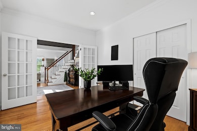
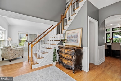
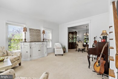
Introducing 75 Bittersweet Drive, a spectacular luxury home in the heart of the coveted Doylestown Lea community in the award-winning Central Bucks School District. This immaculate, 4-bed, 4.1 bath home redefines elegance with its high-end finishes & thoughtful design. The grand foyer welcomes you with sophistication, flanked by a sleek home office to the right showcasing custom millwork & a spacious & inviting sitting room to the left that seamlessly flows into a refined dining room perfect for hosting memorable gatherings. The heart of the home is the chef’s gourmet kitchen, a culinary masterpiece featuring a large center island, quartz countertops & backsplash, top tier appliances including a Wolf 6-gas burner with oversized oven, a Viking double wall oven & a wall mounted pot-filler. Hand-crafted two-tone cabinetry with built in lighting, glass upper cabinet doors & a custom wall of windows overlooking the expansive paver patio & lush gardens provide the finishing touches. Adjacent, the sunlit eat-in breakfast area offers a cozy nook for casual dining, while the great room, with its floor-to-ceiling stone fireplace, provides a warm ambiance for relaxation. A walk-in pantry with a bespoke barn door, a convenient half bath with designer fixtures, a built-in sound system & a well-appointed laundry room with ample storage complete the main level. Ascend the grand staircase, where tranquility awaits. The primary bedroom is a serene retreat, boasting an electric fireplace & generous walk-in closets with tailored organization systems. The primary bathroom is right out of the Four Seasons with its luxurious marble surrounds, electric fireplace above a soaking jacuzzi tub, heated floors, built-in sound system, dual vanities & glass-enclosed shower. The princess suite is complete with its own ensuite bathroom & ample closet space, ideal for guests or family members seeking extra comfort. Two additional bedrooms, each thoughtfully designed with plush carpeting share a well-appointed Jack-&-Jill bathroom, featuring dual sinks & modern fixtures. The finished lower level is an entertainer’s dream, offering a versatile space for leisure & recreation. A state-of-the-art wine cellar, with custom racking holding 200+ bottles, provides the perfect environment for storing & showcasing your collection. The dedicated exercise room is ideal for fitness enthusiasts. Unwind in the media room, featuring plush seating & surround sound for an immersive cinematic experience. Pass by the floor-to-ceiling stone wall showcasing a beautiful gas fireplace as you enter into the billiards room with additional custom millwork creating an inviting atmosphere for friendly competitions. A full bathroom adds convenience & elegance to this remarkable lower level. Step outside to a meticulously landscaped English-style garden with a custom-built trellis perfect for al fresco dining or relaxing in the shade. An elegant iron fence with a graceful gate opens to a lavish rose & flower garden, bursting with vibrant blooms & fragrant blossoms. An arched double-door shed, designed with a dedicated gardening station, offers both functionality & charm for gardening enthusiasts. On the opposite side of the property, an organic raised-bed vegetable garden provides a sustainable space for cultivating fresh produce. Every detail in this home exudes quality, from the intricate millwork, wainscoting & mouldings to the advanced whole-house water filtration system & beautifully designed landscaping. Perfectly situated in one of Doylestown’s most sought-after communities, 75 Bittersweet Drive offers unparalleled access to comfort & convenience. Enjoy a short walk to Central Park, scenic trails, nearby Terrain at DelVal & the soon-to-be-completed Doylestown Township Park Improvement Project. With its prime location & exceptional features, this spectacular home offers a rare opportunity to live in luxury in one of Doylestown’s most popular communities!
Last Agent to Sell the Property
(888) 397-7352 pa.broker@exprealty.net EXP Realty, LLC License #2670520 Listed on: 06/28/2025
Co-Listed By
(888) 397-7352 pa.broker@exprealty.net EXP Realty, LLC License #RS298198
| Date | Type | Sale Price | Title Company |
|---|---|---|---|
| Deed | $1,315,500 | Sage Premier Settlements | |
| Trustee Deed | $364,235 | -- |
| Date | Status | Loan Amount | Loan Type |
|---|---|---|---|
| Open | $825,500 | New Conventional | |
| Previous Owner | $291,000 | No Value Available |
| Date | Event | Price | List to Sale | Price per Sq Ft |
|---|---|---|---|---|
| 09/03/2025 09/03/25 | Sold | $1,315,500 | +1.2% | $230 / Sq Ft |
| 07/26/2025 07/26/25 | Price Changed | $1,300,000 | -1.9% | $227 / Sq Ft |
| 06/28/2025 06/28/25 | For Sale | $1,325,000 | -- | $231 / Sq Ft |
| Year | Tax Paid | Tax Assessment Tax Assessment Total Assessment is a certain percentage of the fair market value that is determined by local assessors to be the total taxable value of land and additions on the property. | Land | Improvement |
|---|---|---|---|---|
| 2025 | $11,991 | $67,760 | $7,480 | $60,280 |
| 2024 | $11,991 | $67,760 | $7,480 | $60,280 |
| 2023 | $11,434 | $67,760 | $7,480 | $60,280 |
| 2022 | $11,306 | $67,760 | $7,480 | $60,280 |
| 2021 | $11,074 | $67,760 | $7,480 | $60,280 |
| 2020 | $11,023 | $67,760 | $7,480 | $60,280 |
| 2019 | $10,904 | $67,760 | $7,480 | $60,280 |
| 2018 | $10,870 | $67,760 | $7,480 | $60,280 |
| 2017 | $10,786 | $67,760 | $7,480 | $60,280 |
| 2016 | $10,718 | $67,760 | $7,480 | $60,280 |
| 2015 | -- | $67,760 | $7,480 | $60,280 |
| 2014 | -- | $67,760 | $7,480 | $60,280 |
Seller's Agent in 2025
Sarah Peters
EXP Realty, LLC
(484) 459-9944
52 in this area
215 Total Sales
J
Seller Co-Listing Agent in 2025
Jane-Linn Citro
EXP Realty, LLC
(267) 974-4187
10 in this area
15 Total Sales
Buyer's Agent in 2025
Patricia Copland
Long & Foster
(215) 208-7322
2 in this area
54 Total Sales
Source: Bright MLS
MLS Number: PABU2099026
APN: 09-059-152
Disclaimer: Certain information contained herein is derived from information provided by parties other than Homes.com. All information provided is deemed reliable, but is not guaranteed to be accurate and should be independently verified.
![]() The data relating to real estate for sale on this website appears in part through the BRIGHT Internet Data Exchange program, a voluntary cooperative exchange of property listing data between licensed real estate brokerage firms, and is provided by BRIGHT through a licensing agreement.
The data relating to real estate for sale on this website appears in part through the BRIGHT Internet Data Exchange program, a voluntary cooperative exchange of property listing data between licensed real estate brokerage firms, and is provided by BRIGHT through a licensing agreement.
Listing information is from various brokers who participate in the Bright MLS IDX program and not all listings may be visible on the site.
The property information being provided on or through the website is for the personal, non-commercial use of consumers and such information may not be used for any purpose other than to identify prospective properties consumers may be interested in purchasing.
Some properties which appear for sale on the website may no longer be available because they are for instance, under contract, sold or are no longer being offered for sale.
Property information displayed is deemed reliable but is not guaranteed.
Copyright 2026 Bright MLS, Inc.
Ask me questions while you tour the home.