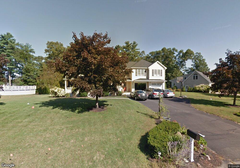
75 Caesar Chelor Dr Wrentham, MA 02093
Estimated Value: $823,000 - $1,034,000
4
Beds
4
Baths
2,770
Sq Ft
$330/Sq Ft
Est. Value
About This Home
This home is located at 75 Caesar Chelor Dr, Wrentham, MA 02093 and is currently estimated at $915,484, approximately $330 per square foot. 75 Caesar Chelor Dr is a home located in Norfolk County with nearby schools including Delaney Elementary School and Charles E Roderick.
Ownership History
Date
Name
Owned For
Owner Type
Purchase Details
Closed on
Aug 13, 2024
Sold by
Martin Kevin G and Martin Paula M
Bought by
Kevin G Martin Ret and Martin
Current Estimated Value
Purchase Details
Closed on
Apr 3, 2000
Sold by
Berry Frank C and Berry Rita M
Bought by
Martin Kevin G and Martin Paula M
Purchase Details
Closed on
Sep 2, 1992
Sold by
Pericolo Constn Inc
Bought by
Berry Frank C and Berry Rita M
Purchase Details
Closed on
Jun 30, 1992
Sold by
Diplacido Thomas W
Bought by
Pericolo Constr Inc
Create a Home Valuation Report for This Property
The Home Valuation Report is an in-depth analysis detailing your home's value as well as a comparison with similar homes in the area
Purchase History
| Date | Buyer | Sale Price | Title Company |
|---|---|---|---|
| Kevin G Martin Ret | -- | None Available | |
| Kevin G Martin Ret | -- | None Available | |
| Martin Kevin G | $272,000 | -- | |
| Berry Frank C | $169,900 | -- | |
| Pericolo Constr Inc | $65,000 | -- |
Source: Public Records
Mortgage History
| Date | Status | Borrower | Loan Amount |
|---|---|---|---|
| Previous Owner | Pericolo Constr Inc | $300,000 | |
| Previous Owner | Pericolo Constr Inc | $100,000 |
Source: Public Records
Tax History
| Year | Tax Paid | Tax Assessment Tax Assessment Total Assessment is a certain percentage of the fair market value that is determined by local assessors to be the total taxable value of land and additions on the property. | Land | Improvement |
|---|---|---|---|---|
| 2025 | $9,388 | $810,000 | $326,900 | $483,100 |
| 2024 | $9,058 | $754,800 | $326,900 | $427,900 |
| 2023 | $8,837 | $700,200 | $297,200 | $403,000 |
| 2022 | $8,348 | $610,700 | $270,300 | $340,400 |
| 2021 | $8,215 | $583,900 | $270,300 | $313,600 |
| 2020 | $8,113 | $569,300 | $222,200 | $347,100 |
| 2019 | $7,818 | $553,700 | $222,200 | $331,500 |
| 2018 | $7,412 | $520,500 | $222,400 | $298,100 |
| 2017 | $7,292 | $511,700 | $218,100 | $293,600 |
| 2016 | $7,137 | $499,800 | $211,800 | $288,000 |
| 2015 | $7,036 | $469,700 | $203,600 | $266,100 |
| 2014 | $6,493 | $424,100 | $167,800 | $256,300 |
Source: Public Records
Map
Nearby Homes
- 10 Nature View Dr
- 15 Nature View Dr
- 2 Earle Stewart Ln
- 3 Earle Stewart Ln
- 12 Earle Stewart Ln
- 10 Earle Stewart Ln Unit Lot 5
- 500 Franklin St
- 287 Park St
- 50 Reed Fulton Ave Unit Lot 61
- 246 Forest Grove Ave
- 45 Joshua Rd
- 576 Dedham St
- 11 Weber Farm Rd Unit 11
- 8 Weber Farm Rd Unit 8
- 0 W Birch Rd
- 30 Weber Farm Rd Unit 30
- 8 Ridgefield Rd
- 483 Thurston St
- 440 Chestnut St
- 75 Jordan Rd
- 85 Caesar Chelor Dr
- 65 Caesar Chelor Dr
- 130 Lakeside Ave
- 95 Caesar Chelor Dr
- 132 Lakeside Ave
- 50 Caesar Chelor Dr
- 134 Lakeside Ave
- 60 Caesar Chelor Dr
- 55 Caesar Chelor Dr
- 136 Lakeside Ave
- 136 Lakeside Ave Unit 136
- 70 Caesar Chelor Dr
- 114 Lakeside Ave
- 40 Caesar Chelor Dr
- 129 Lakeside Ave
- 138 Lakeside Ave
- 125 Lakeside Ave
- 121 Lakeside Ave
- 105 Caesar Chelor Dr
- 135 Lakeside Ave
Your Personal Tour Guide
Ask me questions while you tour the home.