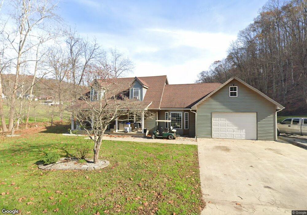
75 Cox Rd Lucasville, OH 45648
Estimated Value: $145,000 - $344,000
3
Beds
2
Baths
1,326
Sq Ft
$209/Sq Ft
Est. Value
About This Home
This home is located at 75 Cox Rd, Lucasville, OH 45648 and is currently estimated at $277,043, approximately $208 per square foot. 75 Cox Rd is a home located in Scioto County with nearby schools including Valley Elementary School, Valley Middle School, and Valley High School.
Ownership History
Date
Name
Owned For
Owner Type
Purchase Details
Closed on
Mar 18, 2025
Sold by
Turner Ryan
Bought by
Turner Ryan
Current Estimated Value
Purchase Details
Closed on
Aug 7, 2017
Sold by
Phillips Jeff and Keller Dawn G
Bought by
Turner Ryan G
Purchase Details
Closed on
May 13, 2016
Sold by
Phillips Jeff
Bought by
Phillips Jeff
Purchase Details
Closed on
Jan 1, 1987
Bought by
Phillips Jeff + Ginger J and Phillips Phillips
Create a Home Valuation Report for This Property
The Home Valuation Report is an in-depth analysis detailing your home's value as well as a comparison with similar homes in the area
Home Values in the Area
Average Home Value in this Area
Purchase History
| Date | Buyer | Sale Price | Title Company |
|---|---|---|---|
| Turner Ryan | -- | None Listed On Document | |
| Turner Ryan | -- | None Listed On Document | |
| Turner Ryan G | $155,000 | -- | |
| Phillips Jeff | -- | -- | |
| Phillips Jeff + Ginger J | -- | -- |
Source: Public Records
Tax History Compared to Growth
Tax History
| Year | Tax Paid | Tax Assessment Tax Assessment Total Assessment is a certain percentage of the fair market value that is determined by local assessors to be the total taxable value of land and additions on the property. | Land | Improvement |
|---|---|---|---|---|
| 2024 | $3,022 | $67,120 | $9,470 | $57,650 |
| 2023 | $3,022 | $67,120 | $9,470 | $57,650 |
| 2022 | $3,015 | $67,120 | $9,470 | $57,650 |
| 2021 | $2,593 | $56,820 | $8,320 | $48,500 |
| 2020 | $2,542 | $56,620 | $8,320 | $48,300 |
| 2019 | $2,490 | $51,490 | $7,580 | $43,910 |
| 2018 | $2,342 | $51,490 | $7,580 | $43,910 |
| 2017 | $1,991 | $51,490 | $7,580 | $43,910 |
| 2016 | $973 | $49,900 | $7,080 | $42,820 |
| 2015 | $1,874 | $49,900 | $7,080 | $42,820 |
| 2013 | $1,668 | $49,900 | $7,080 | $42,820 |
Source: Public Records
Map
Nearby Homes
- 7080 Ohio 139
- 7042 Ohio 139
- 7948 State Route 139
- 8499 Ohio 139
- 296 Clay Dr
- 5628 Ohio 139
- 640 Rases Mountain Dr
- 311 Diane St
- 0-5A Rice Rd
- 0-5B Rice Rd
- 0-5 Rice Rd
- 0-2C Rice Rd
- 0-2B Rice Rd
- 0-2A Rice Rd
- 436 High St
- Lot 9 Hearthstone Dr
- 0 Hearthstone Dr
- 224 Breckenridge Dr
- 448 Houston Hollow Rd
- 13 Cornerstone Dr
- 513 Burns Hollow Rd
- 435 Burns Hollow Rd
- 53 Burns Left Fork Rd
- 53 Burns Left Fork Rd
- 512 Burns Hollow Rd
- 512 Burns Hollow Rd
- 597 Burns Hollow Rd
- 597 Burns Hollow Rd
- 413 Burns Hollow Rd
- 388 Burns Rd
- 92 Burns Left Fork Rd
- 308 Smith Perry Rd
- 371 Burns Hollow Rd
- 388 Burns Hollow Rd
- 645 Burns Hollow Rd
- 126 Burns Left Fork Rd
- 351 Burns Hollow Rd
- 309 Burns Hollow Rd
- 150 Burns Left Fork Rd
- 150 Burns Road Left Fork