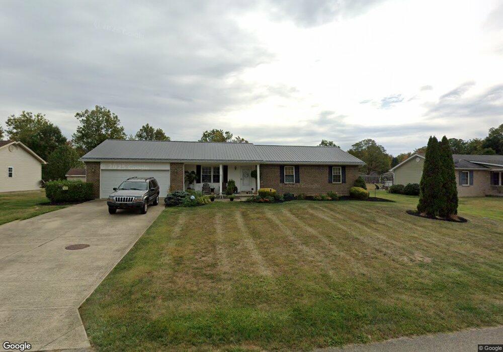
75 Douglas Cir Georgetown, OH 45121
Estimated Value: $228,817 - $265,000
3
Beds
2
Baths
1,604
Sq Ft
$157/Sq Ft
Est. Value
About This Home
This home is located at 75 Douglas Cir, Georgetown, OH 45121 and is currently estimated at $251,704, approximately $156 per square foot. 75 Douglas Cir is a home located in Brown County with nearby schools including Georgetown Elementary School and Georgetown Jr/Sr High School.
Ownership History
Date
Name
Owned For
Owner Type
Purchase Details
Closed on
Oct 7, 2011
Sold by
Wolf Scott A
Bought by
Cropper John P and Cropper Lucinda S
Current Estimated Value
Purchase Details
Closed on
May 11, 2011
Sold by
Burnet Capital Llc
Bought by
Wolf Scott A
Purchase Details
Closed on
Oct 6, 2010
Sold by
White William L
Bought by
U S Bank Na
Purchase Details
Closed on
Aug 14, 2010
Sold by
U S Bank Na
Bought by
Secretary Of Housing & Urban Development
Purchase Details
Closed on
Nov 10, 2005
Sold by
Newsome Paul and Newsome Margaret
Bought by
White William L and White Patricia A
Home Financials for this Owner
Home Financials are based on the most recent Mortgage that was taken out on this home.
Original Mortgage
$109,000
Interest Rate
6.13%
Mortgage Type
FHA
Create a Home Valuation Report for This Property
The Home Valuation Report is an in-depth analysis detailing your home's value as well as a comparison with similar homes in the area
Home Values in the Area
Average Home Value in this Area
Purchase History
| Date | Buyer | Sale Price | Title Company |
|---|---|---|---|
| Cropper John P | $126,000 | None Available | |
| Wolf Scott A | $51,000 | American Homeland Title Agen | |
| Burnet Capital Llc | $44,000 | Attorney | |
| U S Bank Na | $110,274 | None Available | |
| Secretary Of Housing & Urban Development | -- | None Available | |
| White William L | $113,000 | -- |
Source: Public Records
Mortgage History
| Date | Status | Borrower | Loan Amount |
|---|---|---|---|
| Previous Owner | White William L | $109,000 |
Source: Public Records
Tax History
| Year | Tax Paid | Tax Assessment Tax Assessment Total Assessment is a certain percentage of the fair market value that is determined by local assessors to be the total taxable value of land and additions on the property. | Land | Improvement |
|---|---|---|---|---|
| 2024 | $2,428 | $66,980 | $9,710 | $57,270 |
| 2023 | $2,429 | $52,960 | $8,400 | $44,560 |
| 2022 | $2,088 | $52,960 | $8,400 | $44,560 |
| 2021 | $2,069 | $52,960 | $8,400 | $44,560 |
| 2020 | $1,829 | $44,130 | $7,000 | $37,130 |
| 2019 | $1,817 | $44,130 | $7,000 | $37,130 |
| 2018 | $1,805 | $44,130 | $7,000 | $37,130 |
| 2017 | $1,385 | $39,960 | $7,700 | $32,260 |
| 2016 | $1,385 | $39,960 | $7,700 | $32,260 |
| 2015 | $1,436 | $39,960 | $7,700 | $32,260 |
| 2014 | $1,436 | $39,260 | $7,000 | $32,260 |
| 2013 | $1,432 | $39,260 | $7,000 | $32,260 |
Source: Public Records
Map
Nearby Homes
- 175 Douglas Cir
- 20 Douglas Cir
- 25 Douglas Ln
- 155 Free Soil Rd
- 708 E State St
- 666 E State St
- 470 Free Soil Rd
- 20 Heritage Hill Dr
- 505 S Water St
- 406 E North St
- 60 New St
- 399 Elmwood Ct
- 405 N Main St
- 510 W State St
- 0 St Rt 221 & Footbridge Unit 1826509
- 508 Mount Orab Pike
- 427 Kenwood Ave
- 1 N Kenwood Ave
- 2 N Kenwood Ave
- 7029 Free Soil Rd
- 85 Douglas Cir
- 185 Douglas Cir
- 195 Douglas Cir
- 55 Douglas Cir
- 95 Douglas Cir
- 60 Douglas Cir
- 70 Douglas Cir
- 80 Douglas Cir
- 165 Douglas Cir
- 50 Douglas Cir
- 90 Douglas Cir
- 170 Douglas Cir
- 110 Douglas Cir
- 215 Douglas Cir
- 180 Douglas Cir
- 40 Douglas Cir
- 28 Douglas Cir
- 160 Douglas Cir
- 44 Douglas Cir
- 911 S Main St
Your Personal Tour Guide
Ask me questions while you tour the home.