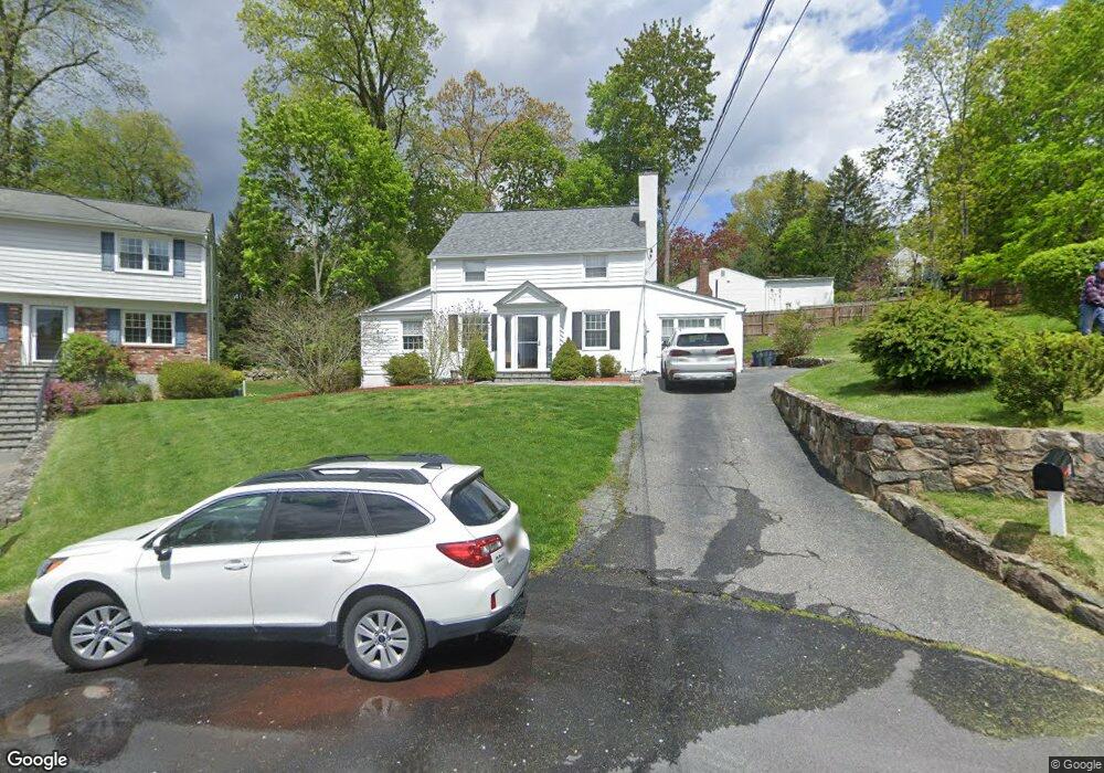
75 Leland Ave Pleasantville, NY 10570
Estimated Value: $685,038 - $923,000
3
Beds
2
Baths
1,891
Sq Ft
$444/Sq Ft
Est. Value
About This Home
This home is located at 75 Leland Ave, Pleasantville, NY 10570 and is currently estimated at $840,260, approximately $444 per square foot. 75 Leland Ave is a home located in Westchester County with nearby schools including Bedford Road School, Pleasantville Middle School, and Pleasantville High School.
Ownership History
Date
Name
Owned For
Owner Type
Purchase Details
Closed on
Jun 15, 2023
Sold by
Sandor David W
Bought by
Manuele Andrew and Manuele Elizabeth
Current Estimated Value
Home Financials for this Owner
Home Financials are based on the most recent Mortgage that was taken out on this home.
Original Mortgage
$570,000
Interest Rate
6.39%
Mortgage Type
New Conventional
Purchase Details
Closed on
Oct 3, 2002
Sold by
Bisordi Reynold N and Bisordi Vera
Bought by
Sandor David W
Home Financials for this Owner
Home Financials are based on the most recent Mortgage that was taken out on this home.
Original Mortgage
$380,000
Interest Rate
6.03%
Mortgage Type
Purchase Money Mortgage
Purchase Details
Closed on
Sep 26, 1996
Sold by
Mcknight Michael F and Mcknight Susan D
Bought by
Bisordi Reynold N and Bisordi Reynold
Create a Home Valuation Report for This Property
The Home Valuation Report is an in-depth analysis detailing your home's value as well as a comparison with similar homes in the area
Home Values in the Area
Average Home Value in this Area
Purchase History
| Date | Buyer | Sale Price | Title Company |
|---|---|---|---|
| Manuele Andrew | $760,000 | Chicago Title Insurance Compan | |
| Sandor David W | $405,000 | The Judicial Title Ins Agenc | |
| Bisordi Reynold N | $234,500 | Chicago Title Insurance Co |
Source: Public Records
Mortgage History
| Date | Status | Borrower | Loan Amount |
|---|---|---|---|
| Previous Owner | Manuele Andrew | $570,000 | |
| Previous Owner | Sandor David W | $380,000 |
Source: Public Records
Tax History Compared to Growth
Tax History
| Year | Tax Paid | Tax Assessment Tax Assessment Total Assessment is a certain percentage of the fair market value that is determined by local assessors to be the total taxable value of land and additions on the property. | Land | Improvement |
|---|---|---|---|---|
| 2024 | $20,085 | $7,550 | $1,350 | $6,200 |
| 2023 | $19,186 | $7,550 | $1,350 | $6,200 |
| 2022 | $15,037 | $7,550 | $1,350 | $6,200 |
| 2021 | $18,507 | $7,550 | $1,350 | $6,200 |
| 2020 | $18,436 | $7,550 | $1,350 | $6,200 |
| 2019 | $14,727 | $7,550 | $1,350 | $6,200 |
| 2018 | $16,012 | $7,550 | $1,350 | $6,200 |
| 2017 | $0 | $7,550 | $1,350 | $6,200 |
| 2016 | $14,292 | $7,550 | $1,350 | $6,200 |
| 2015 | -- | $7,550 | $1,350 | $6,200 |
| 2014 | -- | $7,550 | $1,350 | $6,200 |
| 2013 | -- | $7,550 | $1,350 | $6,200 |
Source: Public Records
Map
Nearby Homes
- 916 Heritage Dr Unit A
- 133 Lake Shore Dr
- 5 Church St Unit 1P
- 174 Lake Shore Dr
- 88 Oak Ridge Rd
- 100 Old Farm Rd N
- 70 Manville Rd Unit 2
- 4 Rockledge Ln
- 4 Larissa Ln
- 19 Club Ct
- 50 Brentwood Dr
- 29 Cedar Ln
- 26 Club Ct
- 10 Grove Mews
- 36 Foxwood Dr Unit 6
- 23 Brookside Place
- 151 Benedict Ave
- 138 Whittier Dr
- 27 Bedford Rd
- 136 Edgewood Ave