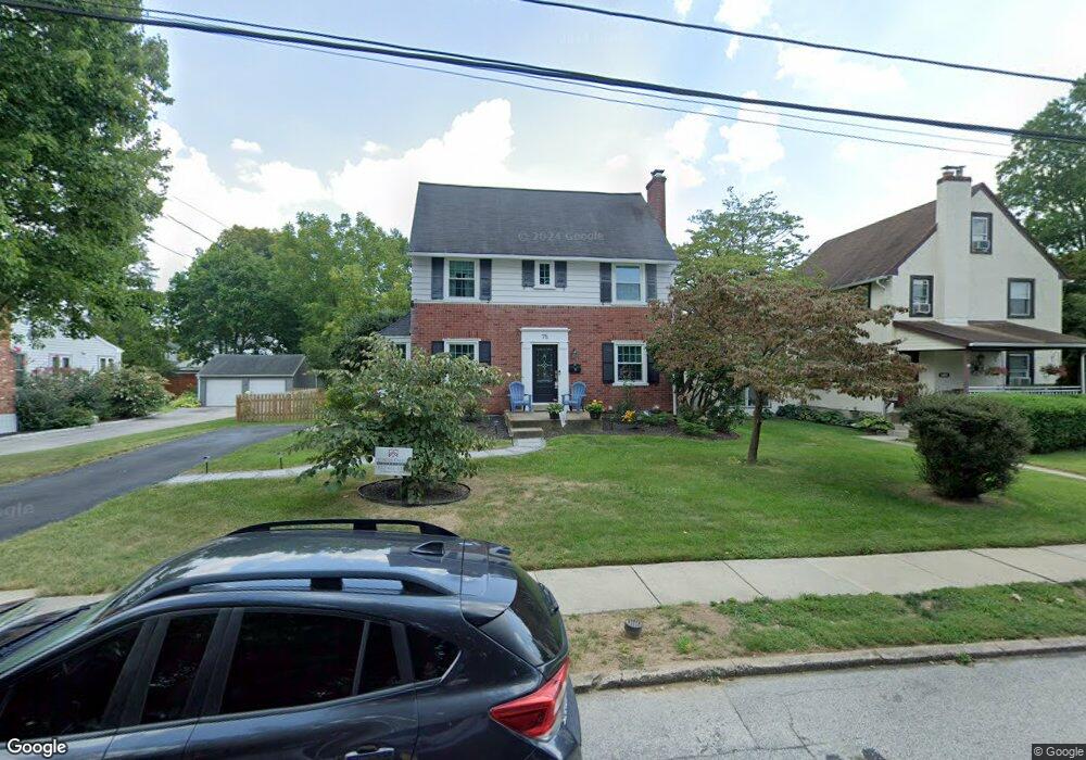
75 Shelburne Rd Springfield, PA 19064
Estimated Value: $540,000 - $617,000
5
Beds
3
Baths
2,272
Sq Ft
$248/Sq Ft
Est. Value
About This Home
This home is located at 75 Shelburne Rd, Springfield, PA 19064 and is currently estimated at $564,264, approximately $248 per square foot. 75 Shelburne Rd is a home located in Delaware County with nearby schools including Springfield High School, St Francis Of Assisi School, and Holy Cross School.
Ownership History
Date
Name
Owned For
Owner Type
Purchase Details
Closed on
Nov 19, 2020
Sold by
Flood Frank E
Bought by
Mccall Michael C and Mccall Moira M
Current Estimated Value
Home Financials for this Owner
Home Financials are based on the most recent Mortgage that was taken out on this home.
Original Mortgage
$236,400
Interest Rate
2.7%
Mortgage Type
New Conventional
Purchase Details
Closed on
Aug 18, 1992
Sold by
Fedor Cynthia A and Fedor David S
Bought by
Flood Frank E and Flood Pamela
Create a Home Valuation Report for This Property
The Home Valuation Report is an in-depth analysis detailing your home's value as well as a comparison with similar homes in the area
Home Values in the Area
Average Home Value in this Area
Purchase History
| Date | Buyer | Sale Price | Title Company |
|---|---|---|---|
| Mccall Michael C | $320,000 | Preferred Closing Svcs Llc | |
| Flood Frank E | $185,000 | -- |
Source: Public Records
Mortgage History
| Date | Status | Borrower | Loan Amount |
|---|---|---|---|
| Previous Owner | Mccall Michael C | $236,400 |
Source: Public Records
Tax History
| Year | Tax Paid | Tax Assessment Tax Assessment Total Assessment is a certain percentage of the fair market value that is determined by local assessors to be the total taxable value of land and additions on the property. | Land | Improvement |
|---|---|---|---|---|
| 2025 | $8,146 | $289,830 | $98,260 | $191,570 |
| 2024 | $8,146 | $289,830 | $98,260 | $191,570 |
| 2023 | $7,844 | $289,830 | $98,260 | $191,570 |
| 2022 | $7,674 | $289,830 | $98,260 | $191,570 |
| 2021 | $11,686 | $284,970 | $98,260 | $186,710 |
| 2020 | $6,830 | $150,730 | $47,240 | $103,490 |
| 2019 | $6,670 | $150,730 | $47,240 | $103,490 |
| 2018 | $6,574 | $150,730 | $0 | $0 |
| 2017 | $6,422 | $150,730 | $0 | $0 |
| 2016 | $827 | $150,730 | $0 | $0 |
| 2015 | $827 | $150,730 | $0 | $0 |
| 2014 | $827 | $150,730 | $0 | $0 |
Source: Public Records
Map
Nearby Homes
- 436 Kerr Ln
- 359 Spring Valley Rd
- 412 Foster Dr
- 606 W Springfield Rd
- 364 S Rolling Rd
- 120 W Springfield Rd
- 641 W Sproul Rd
- 264 Pancoast Ave
- 227 E Leamy Ave
- 226 Lynbrooke Rd
- 225 Lynbrooke Rd
- 249 Gleaves Rd
- 238 Alliston Rd
- 253 Saxer Ave
- 231 E Woodland Ave
- 29 School Ln
- 493 Wheatsheaf Rd
- 501 Flora Cir
- 720 Evans Rd
- 42 Greenhill Rd
- 71 Shelburne Rd
- 79 Shelburne Rd
- 100 Forest Rd
- 63 Shelburne Rd
- 96 Forest Rd
- 92 Forest Rd
- 104 Forest Rd
- 89 Shelburne Rd
- 74 Shelburne Rd
- 78 Shelburne Rd
- Lot 2 Barry Dr
- lot5 Hill Farm Ln
- Lot 3 Hill Farm Ln
- lot 10 Hill Farm Ln
- Lot 1 Hill Farm Ln
- lot20 Hill Farm Ln
- lot8 Hill Farm Ln
- lot 13 Hill Farm Ln
- Lot 2 Hill Farm Ln
- Lot 11 Hill Farm Ln
Your Personal Tour Guide
Ask me questions while you tour the home.