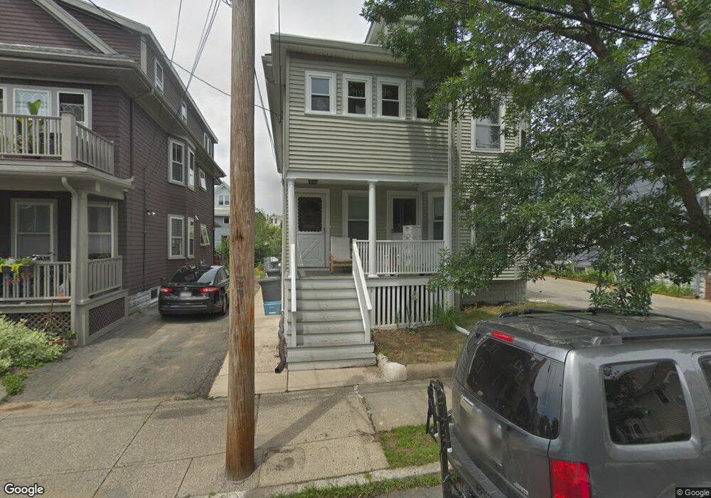
75 Thorndike St Unit 77 Arlington, MA 02474
East Arlington NeighborhoodEstimated Value: $1,453,000 - $1,697,000
4
Beds
3
Baths
2,962
Sq Ft
$539/Sq Ft
Est. Value
About This Home
This home is located at 75 Thorndike St Unit 77, Arlington, MA 02474 and is currently estimated at $1,595,477, approximately $538 per square foot. 75 Thorndike St Unit 77 is a home located in Middlesex County with nearby schools including Hardy Elementary School, Ottoson Middle School, and Arlington High School.
Ownership History
Date
Name
Owned For
Owner Type
Purchase Details
Closed on
Jun 16, 2020
Sold by
Horvath Dora E
Bought by
75-77 Thorndike Street Rt and Horvath
Current Estimated Value
Purchase Details
Closed on
Jul 9, 2004
Sold by
Sullivan David M and Gallant Eileen T
Bought by
Sullivan David M and Gallant Eileen T
Create a Home Valuation Report for This Property
The Home Valuation Report is an in-depth analysis detailing your home's value as well as a comparison with similar homes in the area
Home Values in the Area
Average Home Value in this Area
Purchase History
| Date | Buyer | Sale Price | Title Company |
|---|---|---|---|
| 75-77 Thorndike Street Rt | -- | None Available | |
| Sullivan David M | -- | -- |
Source: Public Records
Tax History Compared to Growth
Tax History
| Year | Tax Paid | Tax Assessment Tax Assessment Total Assessment is a certain percentage of the fair market value that is determined by local assessors to be the total taxable value of land and additions on the property. | Land | Improvement |
|---|---|---|---|---|
| 2025 | $14,955 | $1,388,600 | $577,300 | $811,300 |
| 2024 | $13,658 | $1,289,700 | $549,500 | $740,200 |
| 2023 | $14,027 | $1,251,300 | $460,700 | $790,600 |
| 2022 | $14,020 | $1,227,700 | $444,000 | $783,700 |
| 2021 | $13,530 | $1,193,100 | $444,000 | $749,100 |
| 2020 | $13,197 | $1,193,200 | $444,000 | $749,200 |
| 2019 | $11,537 | $1,024,600 | $471,800 | $552,800 |
| 2018 | $10,879 | $896,900 | $344,100 | $552,800 |
| 2017 | $10,259 | $816,800 | $299,700 | $517,100 |
| 2016 | $9,887 | $772,400 | $255,300 | $517,100 |
| 2015 | $9,545 | $704,400 | $249,800 | $454,600 |
Source: Public Records
Map
Nearby Homes
- 128 Thorndike St Unit 2
- 137-139 Thorndike St Unit 2
- 3 Seagrave Rd
- 23 Brookford St
- 23 Brookford St Unit 2
- 23 Brookford St Unit 1
- 112 Jackson St
- 19 Cottage Park Ave
- 215 Massachusetts Ave Unit 19 (34)
- 127 Harvey St
- 127 Harvey St Unit 127
- 230 Massachusetts Ave Unit 6
- 124 Jackson St
- 49 Clifton St
- 69 Harvey St Unit 1
- 97 Elmwood St Unit 313
- 97 Elmwood St Unit 110
- 97 Elmwood St Unit 310
- 31 Mott St Unit 31A
- 57 Garrison Ave
- 79 Thorndike St Unit 81
- 79 Thorndike St
- 71 Thorndike St Unit 73
- 71 Thorndike St Unit 1
- 85 Thorndike St
- 83 Thorndike St
- 85 Thorndike St Unit 85
- 83 Thorndike St Unit 83
- 69 Thorndike St Unit 2
- 67 Thorndike St Unit 69
- 64 Magnolia St Unit 66
- 56 Magnolia St Unit 58
- 56 Magnolia St Unit 2
- 60 Magnolia St Unit 62
- 62 Magnolia St
- 87 Thorndike St Unit 89
- 89 Thorndike St
- 68 Magnolia St Unit 70
- 65 Thorndike St Unit 65
- 70 Thorndike St Unit 72