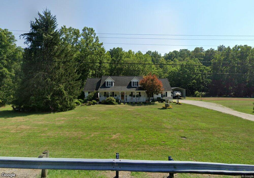
7504 State Route 217 Scottown, OH 45678
Estimated Value: $208,000 - $330,000
3
Beds
3
Baths
2,472
Sq Ft
$115/Sq Ft
Est. Value
About This Home
This home is located at 7504 State Route 217, Scottown, OH 45678 and is currently estimated at $283,214, approximately $114 per square foot. 7504 State Route 217 is a home located in Lawrence County with nearby schools including Symmes Valley Elementary School and Symmes Valley High School.
Ownership History
Date
Name
Owned For
Owner Type
Purchase Details
Closed on
Sep 5, 2023
Sold by
Carrico Kimberly D Le
Bought by
Corn Shawn P
Current Estimated Value
Purchase Details
Closed on
Apr 3, 1997
Sold by
Carrico Carrico R R and Carrico Kim
Bought by
Carrico Carrico R and Carrico Kimberly D
Purchase Details
Closed on
Mar 7, 1997
Sold by
Corn Kimberly D
Bought by
Carrico Carrico R and Carrico Kim
Purchase Details
Closed on
Nov 13, 1992
Sold by
Mcgraw Pat and Mcgraw Beverly
Bought by
Corn Kimberly D
Create a Home Valuation Report for This Property
The Home Valuation Report is an in-depth analysis detailing your home's value as well as a comparison with similar homes in the area
Home Values in the Area
Average Home Value in this Area
Purchase History
| Date | Buyer | Sale Price | Title Company |
|---|---|---|---|
| Corn Shawn P | -- | None Listed On Document | |
| Corn Shawn P | -- | None Listed On Document | |
| Carrico Carrico R | -- | -- | |
| Carrico Carrico R | -- | -- | |
| Corn Kimberly D | -- | -- |
Source: Public Records
Tax History Compared to Growth
Tax History
| Year | Tax Paid | Tax Assessment Tax Assessment Total Assessment is a certain percentage of the fair market value that is determined by local assessors to be the total taxable value of land and additions on the property. | Land | Improvement |
|---|---|---|---|---|
| 2024 | -- | $74,570 | $4,310 | $70,260 |
| 2023 | $2,103 | $74,570 | $4,310 | $70,260 |
| 2022 | $2,101 | $74,570 | $4,310 | $70,260 |
| 2021 | $1,931 | $67,490 | $4,080 | $63,410 |
| 2020 | $1,945 | $67,490 | $4,080 | $63,410 |
| 2019 | $2,045 | $67,490 | $4,080 | $63,410 |
| 2018 | $1,936 | $63,330 | $4,000 | $59,330 |
| 2017 | $1,936 | $63,330 | $4,000 | $59,330 |
| 2016 | $1,800 | $63,330 | $4,000 | $59,330 |
| 2015 | $1,753 | $61,050 | $3,990 | $57,060 |
| 2014 | $1,752 | $61,050 | $3,990 | $57,060 |
| 2013 | $1,751 | $61,050 | $3,990 | $57,060 |
Source: Public Records
Map
Nearby Homes
- 4754 County Road 36
- 181 Private Road 3954
- 810 Township Road 141
- 0 Ohio 378
- 1334 Township Road 214th N
- 1334 McKinney Creek-Hesson Hollow Rd N
- 0 Venisonham-Camp Branch Rd Unit Tract 2
- 0 Venisonham-Camp Branch Rd Unit Tract 1
- 0 Venisonham-Camp Branch Rd
- 0 Venisonham-Camp Branch Rd Unit 25766693
- 0 Venisonham-Camp Branch Rd Unit 3
- 266 Twp Rd 209
- 00 Ohio 217
- 0 Ohio 217
- 168 Township Road 122 W
- 479 Township Road 122
- 66 County Road 30
- State Route 790
- 0 Dillon Ridge Unit 23651508
- 0 Dillon Ridge Unit 181305
- 7479 State Route 217
- 7444 State Route 217
- 7453 State Route 217
- 7598 State Route 217
- 7513 State Route 217
- 7356 State Route 217
- 7345 State Route 217
- 7698 State Route 217
- 7312 Ohio 217
- 7312 State Route 217
- 7730 State Route 217
- 1295 Private Road 3952 Unit 378
- 1243 Private Road 3952
- 7840 State Route 217
- 7159 State Route 217
- 3950 Pvt Rd
- 1392 Private Road 3952
- 357 Private Road 3956
- 326 Private Road 3956 Unit 378
- 326 Private Road 3956