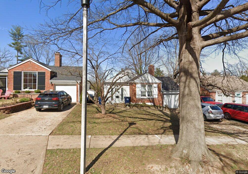
7507 Brunswick Ave Saint Louis, MO 63119
Estimated Value: $277,394 - $316,000
2
Beds
1
Bath
1,121
Sq Ft
$269/Sq Ft
Est. Value
About This Home
This home is located at 7507 Brunswick Ave, Saint Louis, MO 63119 and is currently estimated at $301,599, approximately $269 per square foot. 7507 Brunswick Ave is a home located in St. Louis County with nearby schools including Edgar Road Elementary School, Hixson Middle School, and Webster Groves High School.
Ownership History
Date
Name
Owned For
Owner Type
Purchase Details
Closed on
Oct 26, 2001
Sold by
Schutz Raymond J
Bought by
Schutz James R
Current Estimated Value
Home Financials for this Owner
Home Financials are based on the most recent Mortgage that was taken out on this home.
Original Mortgage
$72,000
Interest Rate
6.71%
Create a Home Valuation Report for This Property
The Home Valuation Report is an in-depth analysis detailing your home's value as well as a comparison with similar homes in the area
Home Values in the Area
Average Home Value in this Area
Purchase History
| Date | Buyer | Sale Price | Title Company |
|---|---|---|---|
| Schutz James R | $90,000 | Capital Title |
Source: Public Records
Mortgage History
| Date | Status | Borrower | Loan Amount |
|---|---|---|---|
| Closed | Schutz James R | $72,000 |
Source: Public Records
Tax History Compared to Growth
Tax History
| Year | Tax Paid | Tax Assessment Tax Assessment Total Assessment is a certain percentage of the fair market value that is determined by local assessors to be the total taxable value of land and additions on the property. | Land | Improvement |
|---|---|---|---|---|
| 2025 | $3,104 | $50,690 | $28,630 | $22,060 |
| 2024 | $3,104 | $43,130 | $14,310 | $28,820 |
| 2023 | $3,104 | $43,130 | $14,310 | $28,820 |
| 2022 | $2,782 | $36,100 | $14,310 | $21,790 |
| 2021 | $2,546 | $36,100 | $14,310 | $21,790 |
| 2020 | $2,754 | $35,460 | $14,310 | $21,150 |
| 2019 | $2,860 | $35,460 | $14,310 | $21,150 |
| 2018 | $2,524 | $28,140 | $12,450 | $15,690 |
| 2017 | $2,505 | $28,140 | $12,450 | $15,690 |
| 2016 | $2,618 | $27,690 | $10,550 | $17,140 |
| 2015 | $2,633 | $27,690 | $10,550 | $17,140 |
| 2014 | $2,567 | $26,270 | $7,140 | $19,130 |
Source: Public Records
Map
Nearby Homes
- 5015 Lenox Ave
- 4 Saint Charles Place
- 25 Saint Charles Place
- 5111 Lenox Ave
- 7316 Brunswick Ave
- 5000 Wilshusen Ave
- 5024 Kain Dr
- 7729 Kenridge Ln
- 7826 Grove Ave
- 7426 Whitehall Colonial Ln
- 7501 Triwoods Dr Unit J
- 5314 N Kenrick Parke Dr Unit 4
- 7723 Suffolk Ave
- 5318 N Kenrick Parke Dr
- 7356 Whitehall Colonial Ln
- 7415 Triwoods Dr Unit C
- 4121 Shrewsbury Ave
- 7366 Westover Colonial Ln Unit 1901
- 946 Newport Ave
- 554 N Laclede Station Rd
- 7509 Brunswick Ave
- 7505 Brunswick Ave
- 7501 Brunswick Ave
- 7511 Brunswick Ave
- 7504 Nottingham Ave
- 7506 Nottingham Ave
- 7502 Nottingham Ave
- 7508 Nottingham Ave
- 7500 Nottingham Ave
- 7515 Brunswick Ave
- 7508 Brunswick Ave
- 7504 Brunswick Ave
- 7510 Brunswick Ave
- 7435 Brunswick Ave
- 7500 Brunswick Ave
- 7512 Nottingham Ave
- 7512 Brunswick Ave
- 7433 Brunswick Ave
- 7424 Nottingham Ave
- 7514 Brunswick Ave