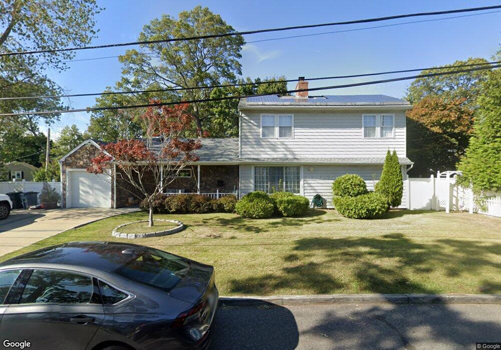
751 Freedom St Babylon, NY 11702
Estimated Value: $710,000 - $731,576
4
Beds
2
Baths
1,746
Sq Ft
$413/Sq Ft
Est. Value
About This Home
This home is located at 751 Freedom St, Babylon, NY 11702 and is currently estimated at $721,894, approximately $413 per square foot. 751 Freedom St is a home located in Suffolk County with nearby schools including Robert Moses Middle School, North Babylon High School, and South Bay Junior Academy.
Ownership History
Date
Name
Owned For
Owner Type
Purchase Details
Closed on
Apr 8, 2021
Sold by
Dionisio Anthony and Dionisio Coleen
Bought by
Gutierrez Marilin
Current Estimated Value
Purchase Details
Closed on
Jul 17, 1998
Sold by
Grusel Elke G and Boland Kevin N
Bought by
Boland Kevin N
Home Financials for this Owner
Home Financials are based on the most recent Mortgage that was taken out on this home.
Original Mortgage
$100,000
Interest Rate
6.58%
Create a Home Valuation Report for This Property
The Home Valuation Report is an in-depth analysis detailing your home's value as well as a comparison with similar homes in the area
Home Values in the Area
Average Home Value in this Area
Purchase History
| Date | Buyer | Sale Price | Title Company |
|---|---|---|---|
| Gutierrez Marilin | $460,000 | None Available | |
| Boland Kevin N | $95,000 | Nations Title Insurance |
Source: Public Records
Mortgage History
| Date | Status | Borrower | Loan Amount |
|---|---|---|---|
| Previous Owner | Boland Kevin N | $100,000 |
Source: Public Records
Tax History
| Year | Tax Paid | Tax Assessment Tax Assessment Total Assessment is a certain percentage of the fair market value that is determined by local assessors to be the total taxable value of land and additions on the property. | Land | Improvement |
|---|---|---|---|---|
| 2024 | $13,720 | $4,060 | $400 | $3,660 |
| 2023 | $13,720 | $4,060 | $400 | $3,660 |
| 2022 | $11,161 | $4,060 | $400 | $3,660 |
| 2021 | $11,161 | $4,060 | $400 | $3,660 |
| 2020 | $11,471 | $4,060 | $400 | $3,660 |
| 2019 | $11,471 | $0 | $0 | $0 |
| 2018 | $11,107 | $4,060 | $400 | $3,660 |
| 2017 | $11,107 | $4,060 | $400 | $3,660 |
| 2016 | $11,057 | $4,060 | $400 | $3,660 |
| 2015 | -- | $4,060 | $400 | $3,660 |
| 2014 | -- | $4,060 | $400 | $3,660 |
Source: Public Records
Map
Nearby Homes
- 60 Liberty Ave
- 1 Freedom Ct
- 7 Lico Place
- 9 Hinton Ave
- 30 Jenkins Ave
- 967 Sunrise Hwy
- 9 Hamilton Ave
- 109 Vesper Ct
- 43 Springwood Dr
- 42 Springwood Dr
- 51 Edmunton Dr Unit F17
- 112 Edmunton Dr Unit C4
- 141 Edmunton Dr Unit G 18
- 103 Foster Blvd
- 111 Edmunton Dr Unit G4
- 192 Edmunton Dr Unit D1
- 294 Edmunton Dr Unit K18
- 265 Edmunton Dr Unit I-12
- 326 Edmunton Dr Unit L-7
- 285 Edmunton Dr Unit 16
- 604 Laurel St
- 615 Floral Place Unit 2
- 615 Floral Place
- 614 Laurel St
- 765 Freedom St
- 752 Freedom St
- 614 Floral Place
- 766 Freedom St
- 742 Freedom St
- 620 Floral Place
- 624 Laurel St
- 770 Freedom St
- 631 Floral Place
- 777 Freedom St
- 721 Freedom St
- 732 Freedom St
- 625 Lotus St
- 30 Burnage Ln
- 32 Burnage Ln
- 615 Laurel St
Your Personal Tour Guide
Ask me questions while you tour the home.