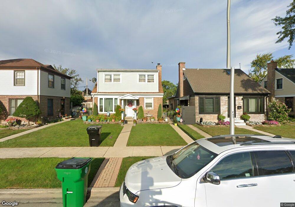
752 Suffolk Ave Westchester, IL 60154
Estimated Value: $289,397 - $326,000
4
Beds
1
Bath
1,322
Sq Ft
$232/Sq Ft
Est. Value
About This Home
This home is located at 752 Suffolk Ave, Westchester, IL 60154 and is currently estimated at $306,599, approximately $231 per square foot. 752 Suffolk Ave is a home located in Cook County with nearby schools including Westchester Primary School, Westchester Intermediate School, and Westchester Middle School.
Ownership History
Date
Name
Owned For
Owner Type
Purchase Details
Closed on
Jul 30, 1997
Sold by
Kazi Nadeem A and Kazi Hajra Shani
Bought by
Guillen Francisco
Current Estimated Value
Home Financials for this Owner
Home Financials are based on the most recent Mortgage that was taken out on this home.
Original Mortgage
$122,300
Outstanding Balance
$24,557
Interest Rate
11.3%
Estimated Equity
$282,042
Create a Home Valuation Report for This Property
The Home Valuation Report is an in-depth analysis detailing your home's value as well as a comparison with similar homes in the area
Home Values in the Area
Average Home Value in this Area
Purchase History
| Date | Buyer | Sale Price | Title Company |
|---|---|---|---|
| Guillen Francisco | $90,666 | Attorneys Natl Title Network |
Source: Public Records
Mortgage History
| Date | Status | Borrower | Loan Amount |
|---|---|---|---|
| Open | Guillen Francisco | $122,300 |
Source: Public Records
Tax History Compared to Growth
Tax History
| Year | Tax Paid | Tax Assessment Tax Assessment Total Assessment is a certain percentage of the fair market value that is determined by local assessors to be the total taxable value of land and additions on the property. | Land | Improvement |
|---|---|---|---|---|
| 2024 | $4,190 | $21,934 | $3,016 | $18,918 |
| 2023 | $3,275 | $21,934 | $3,016 | $18,918 |
| 2022 | $3,275 | $16,891 | $2,654 | $14,237 |
| 2021 | $3,218 | $16,891 | $2,654 | $14,237 |
| 2020 | $3,262 | $16,891 | $2,654 | $14,237 |
| 2019 | $2,710 | $15,765 | $2,413 | $13,352 |
| 2018 | $2,480 | $15,765 | $2,413 | $13,352 |
| 2017 | $3,388 | $15,765 | $2,413 | $13,352 |
| 2016 | $3,612 | $14,882 | $2,171 | $12,711 |
| 2015 | $3,529 | $14,882 | $2,171 | $12,711 |
| 2014 | $3,463 | $14,882 | $2,171 | $12,711 |
| 2013 | $3,655 | $17,169 | $2,171 | $14,998 |
Source: Public Records
Map
Nearby Homes
- 814 Norfolk Ave
- 805 Norfolk Ave
- 920 Suffolk Ave
- 626 Manchester Ave
- 750 Bristol Ave
- 923 Manchester Ave
- 1119 Newcastle Ave
- 723 Balmoral Ave
- 1108 31st Ave
- 1102 31st Ave
- 1136 Park Place
- 1034 31st Ave
- 1023 Rice Ave
- 1022 Eastern Ave
- 10072 Drury Ln
- 1035 Bohland Ave
- 1102 Marshall Ave
- 1013 Bellwood Ave
- 3401 Jackson St
- 3500 Adams St
- 750 Suffolk Ave
- 756 Suffolk Ave
- 760 Suffolk Ave
- 746 Suffolk Ave
- 764 Suffolk Ave
- 740 Suffolk Ave
- 753 Portsmouth Ave
- 755 Portsmouth Ave
- 749 Portsmouth Ave
- 800 Suffolk Ave
- 759 Portsmouth Ave
- 738 Suffolk Ave
- 745 Portsmouth Ave
- 763 Portsmouth Ave
- 741 Portsmouth Ave
- 734 Suffolk Ave
- 801 Portsmouth Ave
- 739 Portsmouth Ave
- 803 Portsmouth Ave
- 810 Suffolk Ave