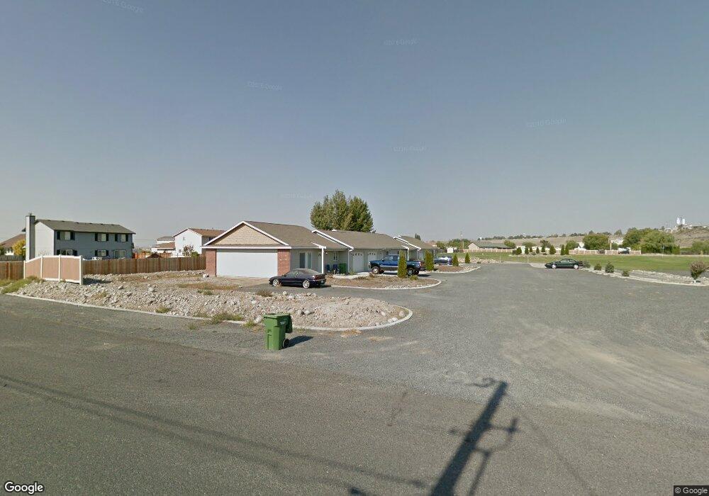
7524 Mcdougal Ave NE Moses Lake, WA 98837
Estimated Value: $182,000 - $256,000
2
Beds
2
Baths
864
Sq Ft
$268/Sq Ft
Est. Value
About This Home
This home is located at 7524 Mcdougal Ave NE, Moses Lake, WA 98837 and is currently estimated at $231,794, approximately $268 per square foot. 7524 Mcdougal Ave NE is a home located in Grant County with nearby schools including Larson Heights Elementary School, Endeavor Middle School, and Moses Lake High School.
Ownership History
Date
Name
Owned For
Owner Type
Purchase Details
Closed on
Jun 5, 2020
Sold by
Osterholz Mildred L and Robertson Carol E
Bought by
Wear Properties Llc
Current Estimated Value
Purchase Details
Closed on
Jun 28, 2018
Sold by
Uniplex Northwest Llc
Bought by
Wear Lester L
Purchase Details
Closed on
May 3, 2018
Sold by
Uniplex Northwest Llc
Bought by
Wear Lester L
Create a Home Valuation Report for This Property
The Home Valuation Report is an in-depth analysis detailing your home's value as well as a comparison with similar homes in the area
Home Values in the Area
Average Home Value in this Area
Purchase History
| Date | Buyer | Sale Price | Title Company |
|---|---|---|---|
| Wear Properties Llc | -- | None Available | |
| Osterholz Mildred L | -- | None Available | |
| Wear Lester L | -- | None Available | |
| Wear Lester L | -- | None Available |
Source: Public Records
Tax History Compared to Growth
Tax History
| Year | Tax Paid | Tax Assessment Tax Assessment Total Assessment is a certain percentage of the fair market value that is determined by local assessors to be the total taxable value of land and additions on the property. | Land | Improvement |
|---|---|---|---|---|
| 2025 | $1,608 | $150,825 | -- | -- |
| 2024 | $1,386 | $109,575 | $0 | $109,575 |
| 2023 | $1,244 | $102,910 | $0 | $102,910 |
| 2022 | $1,294 | $102,910 | $0 | $102,910 |
| 2021 | $1,178 | $102,910 | $0 | $102,910 |
| 2020 | $1,772 | $102,630 | $0 | $102,630 |
| 2019 | $1,852 | $127,205 | $12,770 | $114,435 |
| 2018 | $1,911 | $119,750 | $12,770 | $106,980 |
| 2017 | $1,706 | $110,060 | $12,770 | $97,290 |
| 2016 | $1,638 | $103,620 | $12,770 | $90,850 |
| 2013 | -- | $93,210 | $8,490 | $84,720 |
Source: Public Records
Map
Nearby Homes
- 4926 Shorecrest Dr NE
- 4898 Shorecrest Dr NE
- 7613 Cox St NE
- 141 Carswell Dr
- 9035 Forrestal Ln
- 9023 Mcconnell Dr Unit A
- 9021 Mcconnell Dr Unit A
- 9016 Bong Loop Unit B
- 205 March Dr NE
- 4815 Airway Dr NE Unit 86
- 4815 Airway Dr NE Unit 72
- 4815 Airway Dr NE Unit 12
- 9008 Bong Loop Unit B
- 410 Biggs Dr NE
- 8958 Tinker Loop Unit A & B
- 428 Biggs Rd Unit 430
- 0 Kopp Ln NE
- 1127 Arlington Dr
- 3924 Evans Ln NE
- 7887 Dahl Rd NE
- 7524 Mcdougal Ave NE Unit D
- 7524 Mcdougal Ave NE Unit C
- 7524 Mcdougal Ave NE Unit B
- 7524 Mcdougal Ave NE Unit A
- 7524 Mcdougal Ave NE
- 7524 Mcdougal Ave NE
- 7524 Mcdougal Ave NE
- 4963 Shorecrest Dr NE
- 4261 W Wood Ct
- 4210 W Wood Ct
- 4209 W Wood Ct
- 4925 Shorecrest Dr NE
- 4905 Shorecrest Dr NE
- 4943 Shorecrest Dr NE
- 4940 Shorecrest Dr NE
- 4875 Shorecrest Dr NE
- 3986 Shorecrest Dr NE
- 3915 Shorecrest Dr NE
- 3951 Shorecrest Dr NE
- 3816 Shorecrest Dr NE