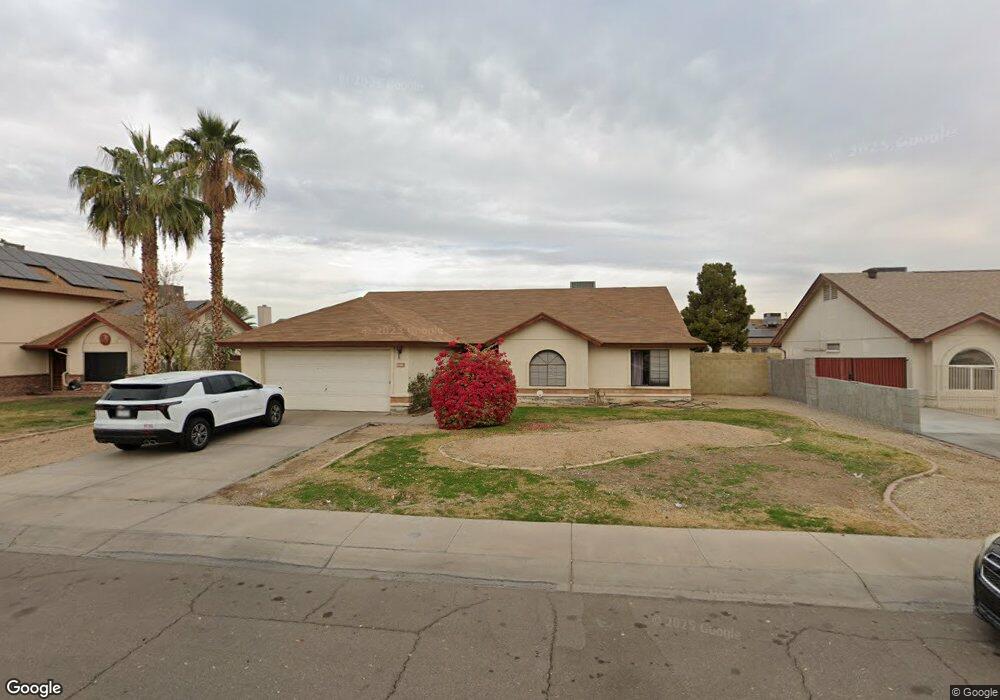
7538 W Brown St Peoria, AZ 85345
Estimated Value: $369,197 - $484,000
--
Bed
2
Baths
2,105
Sq Ft
$207/Sq Ft
Est. Value
About This Home
This home is located at 7538 W Brown St, Peoria, AZ 85345 and is currently estimated at $435,299, approximately $206 per square foot. 7538 W Brown St is a home located in Maricopa County with nearby schools including Santa Fe Elementary School, Peoria High School, and Academy of Math and Science - Peoria Advanced.
Ownership History
Date
Name
Owned For
Owner Type
Purchase Details
Closed on
Dec 18, 2008
Sold by
Scott Vincent A and Ohling Donna Kay
Bought by
Mccormick Jane E
Current Estimated Value
Purchase Details
Closed on
Sep 2, 1999
Sold by
Fuse Roy H
Bought by
Scott Vincent A and Ohling Donna Kay
Home Financials for this Owner
Home Financials are based on the most recent Mortgage that was taken out on this home.
Original Mortgage
$52,849
Interest Rate
7.86%
Mortgage Type
New Conventional
Create a Home Valuation Report for This Property
The Home Valuation Report is an in-depth analysis detailing your home's value as well as a comparison with similar homes in the area
Home Values in the Area
Average Home Value in this Area
Purchase History
| Date | Buyer | Sale Price | Title Company |
|---|---|---|---|
| Mccormick Jane E | -- | None Available | |
| Scott Vincent A | $128,900 | Capital Title Agency |
Source: Public Records
Mortgage History
| Date | Status | Borrower | Loan Amount |
|---|---|---|---|
| Previous Owner | Scott Vincent A | $52,849 |
Source: Public Records
Tax History Compared to Growth
Tax History
| Year | Tax Paid | Tax Assessment Tax Assessment Total Assessment is a certain percentage of the fair market value that is determined by local assessors to be the total taxable value of land and additions on the property. | Land | Improvement |
|---|---|---|---|---|
| 2025 | $1,391 | $14,882 | -- | -- |
| 2024 | $1,364 | $14,173 | -- | -- |
| 2023 | $1,364 | $29,950 | $5,990 | $23,960 |
| 2022 | $1,338 | $23,100 | $4,620 | $18,480 |
| 2021 | $1,401 | $21,110 | $4,220 | $16,890 |
| 2020 | $1,410 | $19,430 | $3,880 | $15,550 |
| 2019 | $1,367 | $17,700 | $3,540 | $14,160 |
| 2018 | $1,326 | $16,630 | $3,320 | $13,310 |
| 2017 | $1,323 | $14,310 | $2,860 | $11,450 |
| 2016 | $1,307 | $14,130 | $2,820 | $11,310 |
| 2015 | $1,216 | $13,380 | $2,670 | $10,710 |
Source: Public Records
Map
Nearby Homes
- 7508 W Beryl Ave
- 7726 W Cheryl Dr
- 7336 W Cheryl Dr
- 7810 W Peoria Ave Unit 166
- 7810 W Peoria Ave Unit 74
- 7810 W Peoria Ave Unit 121
- 7810 W Peoria Ave Unit 98
- 7810 W Peoria Ave Unit 152
- 7810 W Peoria Ave Unit 85
- 7810 W Peoria Ave Unit 79
- 7810 W Peoria Ave Unit 174
- 7302 W Peoria Ave Unit 115
- 9167 N 73rd Ln
- 9672 N 72nd Ave
- 10955 N 79th Ave Unit 147
- 10955 N 79th Ave Unit 60
- 10955 N 79th Ave Unit 113
- 10955 N 79th Ave Unit 163
- 10955 N 79th Ave Unit 179
- 10955 N 79th Ave Unit 40
- 7532 W Brown St
- 7544 W Brown St
- 7537 W Cheryl Dr
- 7543 W Cheryl Dr
- 7531 W Cheryl Dr
- 7526 W Brown St
- 7537 W Brown St
- 7543 W Brown St Unit A
- 7543 W Brown St
- 7531 W Brown St
- 7525 W Cheryl Dr
- 7601 W Cheryl Dr
- 7601 W Brown St
- 7525 W Brown St
- 7520 W Brown St
- 7608 W Brown St
- 7519 W Cheryl Dr
- 7607 W Cheryl Dr Unit *See*
- 7607 W Cheryl Dr
- 7538 W Cheryl Dr