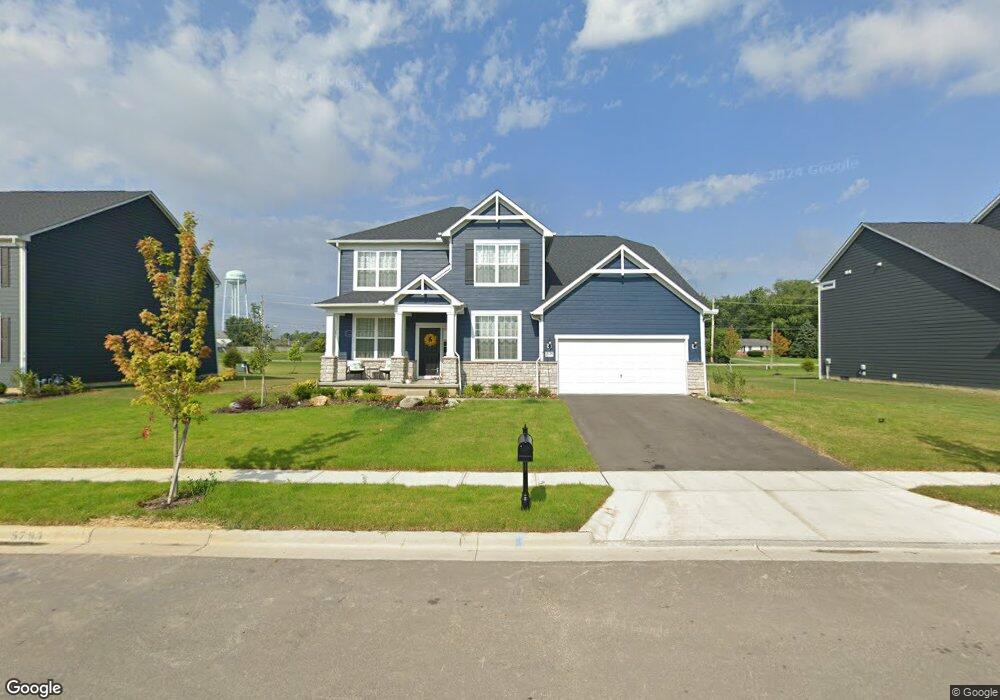
7545 White Cap Dr Powell, OH 43065
Liberty Township NeighborhoodEstimated Value: $669,893 - $687,000
4
Beds
4
Baths
3,296
Sq Ft
$206/Sq Ft
Est. Value
About This Home
This home is located at 7545 White Cap Dr, Powell, OH 43065 and is currently estimated at $679,223, approximately $206 per square foot. 7545 White Cap Dr is a home with nearby schools including Liberty Tree Elementary School, Hyatts Middle School, and Olentangy Berlin High School.
Ownership History
Date
Name
Owned For
Owner Type
Purchase Details
Closed on
Jan 21, 2021
Bought by
Brains Banda and Surbhi Mehta
Current Estimated Value
Home Financials for this Owner
Home Financials are based on the most recent Mortgage that was taken out on this home.
Interest Rate
2.77%
Purchase Details
Closed on
Dec 31, 2020
Sold by
Pulte Homes Of Ohio Llc
Bought by
Banda Brains and Banda Surbhi Mehta
Home Financials for this Owner
Home Financials are based on the most recent Mortgage that was taken out on this home.
Interest Rate
2.77%
Create a Home Valuation Report for This Property
The Home Valuation Report is an in-depth analysis detailing your home's value as well as a comparison with similar homes in the area
Home Values in the Area
Average Home Value in this Area
Purchase History
| Date | Buyer | Sale Price | Title Company |
|---|---|---|---|
| Brains Banda | $463,555 | -- | |
| Banda Brains | $463,600 | None Available |
Source: Public Records
Mortgage History
| Date | Status | Borrower | Loan Amount |
|---|---|---|---|
| Closed | Brains Banda | -- | |
| Open | Banda Brains | $440,377 |
Source: Public Records
Tax History Compared to Growth
Tax History
| Year | Tax Paid | Tax Assessment Tax Assessment Total Assessment is a certain percentage of the fair market value that is determined by local assessors to be the total taxable value of land and additions on the property. | Land | Improvement |
|---|---|---|---|---|
| 2024 | $11,403 | $197,370 | $39,900 | $157,470 |
| 2023 | $11,433 | $197,370 | $39,900 | $157,470 |
| 2022 | $10,392 | $148,750 | $29,750 | $119,000 |
| 2021 | $10,572 | $148,750 | $29,750 | $119,000 |
| 2020 | $2,140 | $26,780 | $26,780 | $0 |
| 2019 | $922 | $9,380 | $9,380 | $0 |
| 2018 | $622 | $9,380 | $9,380 | $0 |
Source: Public Records
Map
Nearby Homes
- 3296 Home Rd
- 3143 Rossmore Cir
- 0 Home Rd Unit 224041180
- 7030 Kinsale Ln
- 2377 Home Rd
- 0 Home Rd Unit 225042181
- 2497 Nelson Ln
- Castleton Plan at Nelson Farms
- Allison II Plan at Nelson Farms
- Deer Valley Plan at Nelson Farms
- Woodside Plan at Nelson Farms
- Melrose Plan at Nelson Farms
- Willwood Plan at Nelson Farms
- Maple Valley Plan at Nelson Farms
- 2932 Beechwood Dr
- 3738 Pine Bank Dr
- 2537 Rangeland Dr Unit Lot 7091
- 2521 Rangeland Dr Unit Lot 7090
- 6505 Longview Dr
- 3402 Winding Woods Dr
- 7531 White Cap Dr
- 7559 White Cap Dr
- 7505 White Cap Dr
- 7573 White Cap Dr
- 7517 White Cap Dr
- 7550 White Cap Dr
- 7536 White Cap Dr
- 7564 White Cap Dr
- 7524 White Cap Dr
- 7578 White Cap Dr
- 7601 Whitecap Dr
- 7497 Whitecap Dr Unit Lot 5789
- 7500 White Cap Dr
- 7649 Whitecap Dr
- 2851 Summerland Loop
- 2823 Summerland Loop
- 7201 Old Liberty Rd
- 2875 Summerland Loop
- Lot 5810 Summerland Loop
- 7483 White Cap Dr