Estimated Value: $287,989 - $328,000
--
Bed
--
Bath
768
Sq Ft
$406/Sq Ft
Est. Value
About This Home
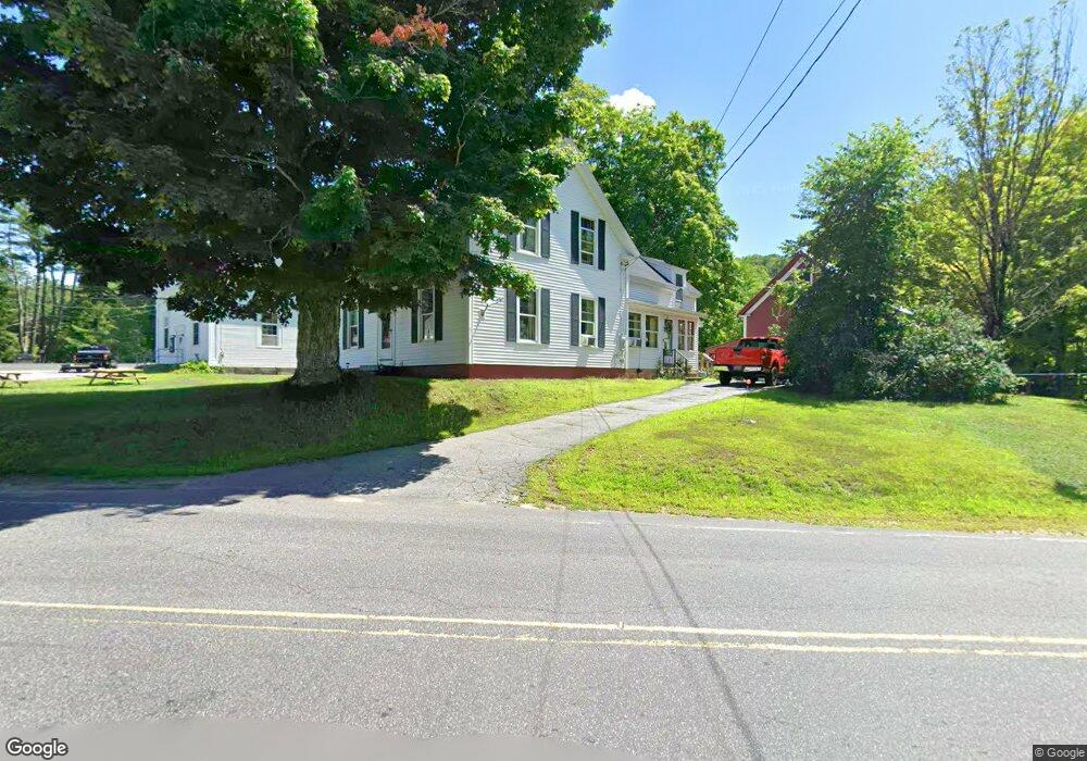
This home is located at 755 W Minot Rd, Minot, ME 04258 and is currently estimated at $311,747, approximately $405 per square foot. 755 W Minot Rd is a home with nearby schools including Minot Consolidated School and Hebron Academy.
Ownership History
Date
Name
Owned For
Owner Type
Purchase Details
Closed on
Jun 23, 2025
Sold by
Slattery Wayne
Bought by
Slattery Wayne and Slattery Matthew S
Current Estimated Value
Home Financials for this Owner
Home Financials are based on the most recent Mortgage that was taken out on this home.
Original Mortgage
$225,000
Outstanding Balance
$224,422
Interest Rate
6.81%
Mortgage Type
Purchase Money Mortgage
Estimated Equity
$87,325
Create a Home Valuation Report for This Property
The Home Valuation Report is an in-depth analysis detailing your home's value as well as a comparison with similar homes in the area
Home Values in the Area
Average Home Value in this Area
Purchase History
| Date | Buyer | Sale Price | Title Company |
|---|---|---|---|
| Slattery Wayne | $300,000 | None Available | |
| Slattery Wayne | $300,000 | None Available | |
| Slattery Wayne | -- | None Available | |
| Slattery Wayne | -- | None Available |
Source: Public Records
Mortgage History
| Date | Status | Borrower | Loan Amount |
|---|---|---|---|
| Open | Slattery Wayne | $225,000 | |
| Closed | Slattery Wayne | $225,000 |
Source: Public Records
Tax History Compared to Growth
Tax History
| Year | Tax Paid | Tax Assessment Tax Assessment Total Assessment is a certain percentage of the fair market value that is determined by local assessors to be the total taxable value of land and additions on the property. | Land | Improvement |
|---|---|---|---|---|
| 2024 | $2,554 | $229,043 | $62,400 | $166,643 |
| 2023 | $2,290 | $229,043 | $62,400 | $166,643 |
| 2022 | $2,256 | $229,043 | $62,400 | $166,643 |
| 2021 | $2,272 | $137,281 | $27,060 | $110,221 |
| 2020 | $2,272 | $137,281 | $27,060 | $110,221 |
| 2019 | $2,176 | $137,281 | $27,060 | $110,221 |
| 2018 | $2,176 | $137,281 | $27,060 | $110,221 |
| 2017 | $2,155 | $137,281 | $27,060 | $110,221 |
| 2016 | $2,114 | $137,281 | $27,060 | $110,221 |
| 2015 | $2,142 | $137,281 | $27,060 | $110,221 |
| 2014 | $2,059 | $137,281 | $27,060 | $110,221 |
Source: Public Records
Map
Nearby Homes
- 1269 Woodman Hill Rd
- 434 Brighton Hill Rd
- 450 Millett Rd
- 78 Star Dr
- 45 Station Rd
- 37 Goldenrod Ln
- 241 Allen Rd
- R03-007-A Pottle Hill Rd
- Lot A Station Rd
- Lot 21B Station Rd
- 11 Scenic Heights Dr
- 12 Scenic Heights Dr
- 10 Scenic Heights Dr
- 14 Scenic Heights Dr
- 13 Scenic Heights Dr
- 15 Scenic Heights Dr
- 24 Clifford St
- 22 N Town Farm Rd
- 31 Sodom Rd
- 62 North St
- 1330 Woodman Hill Rd
- 767 W Minot Rd
- 758 W Minot Rd
- 1339 Woodman Hill Rd
- 1352 Woodman Hill Rd
- 1347 Woodman Hill Rd
- 1345 Woodman Hill Rd
- 780 W Minot Rd
- 746 W Minot Rd
- 8 Carriage Rd
- 788 W Minot Rd
- 1366 Woodman Hill Rd
- 15 Libby Rd
- 1361 Woodman Hill Rd
- 1312 Woodman Hill Rd
- 721 W Minot Rd
- 16 Libby Rd
- 783 W Minot Rd
- 1296 Woodman Hill Rd
- 718 W Minot Rd