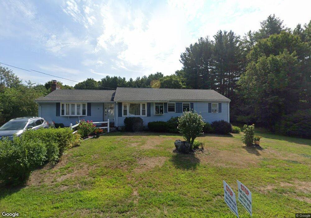
759 Livingston St Tewksbury, MA 01876
Estimated Value: $693,000 - $777,000
3
Beds
2
Baths
1,960
Sq Ft
$374/Sq Ft
Est. Value
About This Home
This home is located at 759 Livingston St, Tewksbury, MA 01876 and is currently estimated at $733,586, approximately $374 per square foot. 759 Livingston St is a home located in Middlesex County with nearby schools including John F. Ryan Elementary School, John W. Wynn Middle School, and Tewksbury Memorial High School.
Ownership History
Date
Name
Owned For
Owner Type
Purchase Details
Closed on
Mar 13, 2023
Sold by
Penney Kathleen
Bought by
Penney Irt
Current Estimated Value
Purchase Details
Closed on
Nov 7, 1975
Bought by
Penney Raymond C and Penney Kathleen
Create a Home Valuation Report for This Property
The Home Valuation Report is an in-depth analysis detailing your home's value as well as a comparison with similar homes in the area
Home Values in the Area
Average Home Value in this Area
Purchase History
| Date | Buyer | Sale Price | Title Company |
|---|---|---|---|
| Penney Irt | -- | None Available | |
| Penney Raymond C | $31,000 | -- |
Source: Public Records
Mortgage History
| Date | Status | Borrower | Loan Amount |
|---|---|---|---|
| Previous Owner | Penney Raymond C | $30,000 | |
| Previous Owner | Penney Raymond C | $120,000 | |
| Previous Owner | Penney Raymond C | $36,000 | |
| Previous Owner | Penney Raymond C | $55,000 |
Source: Public Records
Tax History Compared to Growth
Tax History
| Year | Tax Paid | Tax Assessment Tax Assessment Total Assessment is a certain percentage of the fair market value that is determined by local assessors to be the total taxable value of land and additions on the property. | Land | Improvement |
|---|---|---|---|---|
| 2025 | $8,114 | $613,800 | $306,000 | $307,800 |
| 2024 | $7,836 | $585,200 | $291,600 | $293,600 |
| 2023 | $7,723 | $547,700 | $265,000 | $282,700 |
| 2022 | $7,539 | $496,000 | $230,600 | $265,400 |
| 2021 | $13,109 | $460,500 | $209,700 | $250,800 |
| 2020 | $7,531 | $436,200 | $199,700 | $236,500 |
| 2019 | $6,677 | $421,500 | $190,100 | $231,400 |
| 2018 | $6,362 | $394,400 | $190,100 | $204,300 |
| 2017 | $6,753 | $369,400 | $190,100 | $179,300 |
| 2016 | $5,858 | $358,300 | $190,100 | $168,200 |
| 2015 | $5,500 | $336,000 | $184,400 | $151,600 |
| 2014 | $5,025 | $311,900 | $184,400 | $127,500 |
Source: Public Records
Map
Nearby Homes
- 51 Nolan Ct Unit 51
- 13 Berkeley
- 5 Kensington Way Unit 5
- 110 Royal Crest Cir
- 399 North St
- 11 Orchard St
- 20 Meredith Rd
- 61 Patrick Rd
- 1334 Main St
- 1325 Main
- 1170 Livingston St
- 142 Patrick Rd
- 1418 Main St Unit 201
- 1117 Emerald Ct
- 11 Emerald Ct
- 1224 Emerald Ct
- 100 Pleasant St Unit 14
- 68 Catamount Rd
- 1455 Main St Unit 4
- 1455 Main St Unit 10
- 769 Livingston St
- 752 Livingston St
- 762 Livingston St
- Lot 5 Chandler St
- 11 Katie Way
- 11 Katie Way
- 21 Katie Way
- 3 Chandler St
- 31 Katie Way
- 41 Katie Way
- 737 Livingston St
- 721 Livingston St
- 11 Chandler St
- 715 Livingston St
- 731 Livingston St
- 20 Katie Way
- 61 Katie Way
- 777 Livingston St
- 30 Katie Way
- 6 Chandler St