Estimated Value: $142,483 - $190,000
--
Bed
--
Bath
832
Sq Ft
$197/Sq Ft
Est. Value
About This Home
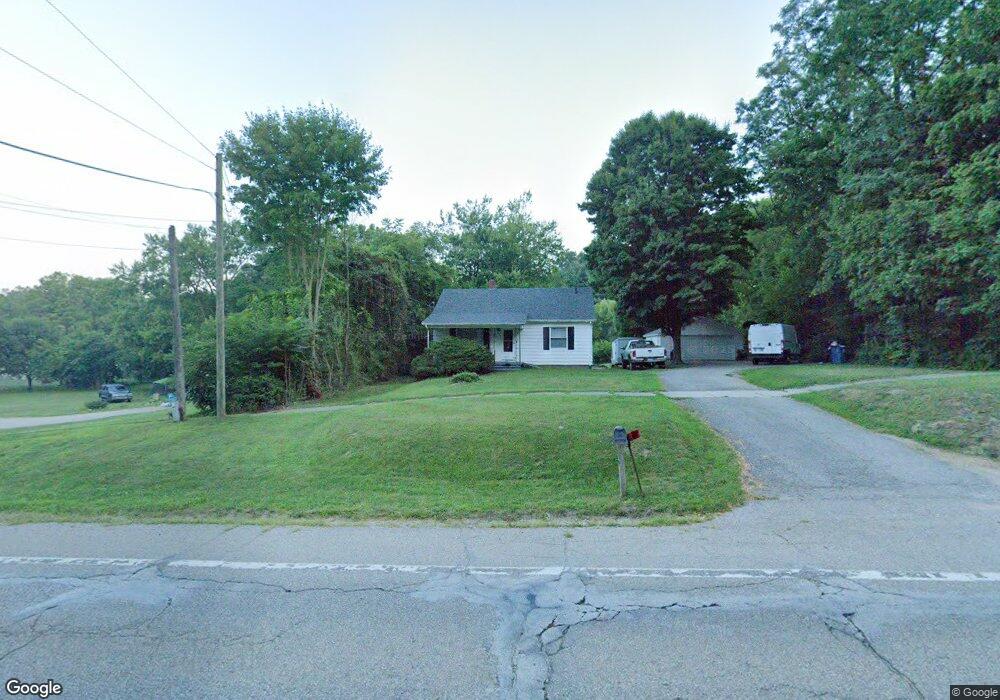
This home is located at 759 W Chicago Rd, Niles, MI 49120 and is currently estimated at $163,621, approximately $196 per square foot. 759 W Chicago Rd is a home located in Berrien County with nearby schools including Ballard Elementary School, Oak Manor Sixth Grade Center, and Ring Lardner Middle School.
Ownership History
Date
Name
Owned For
Owner Type
Purchase Details
Closed on
Mar 31, 2023
Sold by
Mercado Felix and Mercado Kevin
Bought by
Mercado Kevin and Mercado Christian
Current Estimated Value
Home Financials for this Owner
Home Financials are based on the most recent Mortgage that was taken out on this home.
Original Mortgage
$71,600
Interest Rate
6.81%
Mortgage Type
New Conventional
Purchase Details
Closed on
Nov 5, 1998
Purchase Details
Closed on
Sep 18, 1990
Create a Home Valuation Report for This Property
The Home Valuation Report is an in-depth analysis detailing your home's value as well as a comparison with similar homes in the area
Home Values in the Area
Average Home Value in this Area
Purchase History
| Date | Buyer | Sale Price | Title Company |
|---|---|---|---|
| Mercado Kevin | -- | None Listed On Document | |
| -- | $100 | -- | |
| -- | $36,900 | -- |
Source: Public Records
Mortgage History
| Date | Status | Borrower | Loan Amount |
|---|---|---|---|
| Previous Owner | Mercado Kevin | $71,600 |
Source: Public Records
Tax History Compared to Growth
Tax History
| Year | Tax Paid | Tax Assessment Tax Assessment Total Assessment is a certain percentage of the fair market value that is determined by local assessors to be the total taxable value of land and additions on the property. | Land | Improvement |
|---|---|---|---|---|
| 2025 | $1,528 | $61,500 | $0 | $0 |
| 2024 | $1,190 | $57,000 | $0 | $0 |
| 2023 | $1,141 | $49,800 | $0 | $0 |
| 2022 | $1,087 | $54,000 | $0 | $0 |
| 2021 | $1,347 | $47,500 | $7,500 | $40,000 |
| 2020 | $1,333 | $49,400 | $0 | $0 |
| 2019 | $1,311 | $38,200 | $3,400 | $34,800 |
| 2018 | $1,281 | $38,200 | $0 | $0 |
| 2017 | $1,247 | $32,500 | $0 | $0 |
| 2016 | $1,315 | $37,600 | $0 | $0 |
| 2015 | $1,305 | $41,200 | $0 | $0 |
| 2014 | $1,018 | $41,000 | $0 | $0 |
Source: Public Records
Map
Nearby Homes
- V/L Wesaw Rd
- 1010 Tomahawk Ln
- 413 S Street Joseph Ave
- 124 S State St
- 211 S Street Joseph Ave
- 537 Grant St
- 1639 Sioux Trail
- 211 S 4th St
- 300 Carefree Ct
- 319 S 5th St
- Integrity 1610 Plan at Carefree Villas
- Integrity 1605 Plan at Carefree Villas
- Integrity 1250 Plan at Carefree Villas
- Integrity 1530 Plan at Carefree Villas
- 340 Carefree Ct
- 712 Maple St
- VL Huron St
- 705 Oak St
- 1695 Signal Point Dr
- 314 N 6th St
- 755 W Chicago Rd
- 767 W Chicago Rd
- 0 Hillcrest Rd Unit 58050117058
- 0 Hillcrest Rd Unit 50117058
- 0 Hillcrest Rd
- 747 W Chicago Rd
- 526 Hillcrest Rd
- 527 Hillcrest Rd
- 523 Hillcrest Rd
- 785 W Chicago Rd
- 519 Meadow Dr
- 710 W Chicago Rd
- 789 W Chicago Rd
- 519 Hillcrest Rd
- 523 Meadow Dr
- 515 Hillcrest Rd
- 527 Meadow Dr
- 502 Hillcrest Rd
- 721 Sassafras Ln
- 531 Meadow Dr