
Seller's Agent in 2023
Connie Crotzer
Keller Williams Community Partners
(470) 239-0854
7 in this area
15 Total Sales
Estimated Value: $510,173 - $674,000
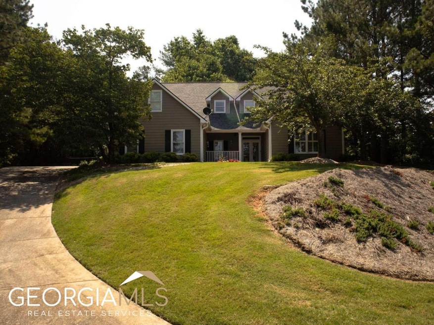
Well-maintained home in the city of Dahlonega, a rare find. No HOA, Master suite on main with double vanity, walk-in closet, separate tub/shower. Large laundry room and 2 bedrooms with Jack n Jill bathroom on the main floor. Spacious kitchen with plenty of cabinets with breakfast bar and separate eating area. Upstairs you'll find another living area great for family tv night and 2 more bedrooms 1 with a full bathroom. Carpeted bedrooms, hardwood floors throughout the remainder of the home. Wood blinds in all the windows. Built-in bookshelves along stair wall. Enjoy cool nights by the gas fireplace. Fenced in backyard with a patio area does not encompass the whole property so room for a pool. Newer roof, facet, gutters, and downspout. Hot water heater is new. Sprinkler system, PROUD alarm system, Trane smart thermostat control for HVAC. Owner occupied, please allow 1-hour notice in order to take small dogs off of the premises. DO NOT show up without confirmation. Preferred closing attorney, David Strauss with Okelley and Sorohan in Cumming.
Last Agent to Sell the Property
Keller Williams Community Partners License #413717 Listed on: 07/03/2023
Last Buyer's Agent
Keller Williams Community Partners License #413717 Listed on: 07/03/2023
| Date | Buyer | Sale Price | Title Company |
|---|---|---|---|
| Johnsen Caroline Barker | $262,500 | -- | |
| Meyer David E | $200,000 | -- | |
| Biggs Ben Paul | $190,000 | -- |
| Date | Event | Price | List to Sale | Price per Sq Ft |
|---|---|---|---|---|
| 08/15/2023 08/15/23 | Sold | $450,000 | 0.0% | $144 / Sq Ft |
| 07/18/2023 07/18/23 | Pending | -- | -- | -- |
| 07/03/2023 07/03/23 | For Sale | $450,000 | -- | $144 / Sq Ft |
| Year | Tax Paid | Tax Assessment Tax Assessment Total Assessment is a certain percentage of the fair market value that is determined by local assessors to be the total taxable value of land and additions on the property. | Land | Improvement |
|---|---|---|---|---|
| 2024 | $5,766 | $198,724 | $12,500 | $186,224 |
| 2023 | $1,303 | $160,680 | $12,500 | $148,180 |
| 2022 | $1,535 | $145,947 | $12,500 | $133,447 |
| 2021 | $875 | $116,686 | $12,500 | $104,186 |
| 2020 | $848 | $113,282 | $12,500 | $100,782 |
| 2019 | $859 | $113,282 | $12,500 | $100,782 |
| 2018 | $680 | $100,105 | $12,500 | $87,605 |
| 2017 | $581 | $94,157 | $12,500 | $81,657 |
| 2016 | $420 | $85,391 | $12,500 | $72,891 |
| 2015 | $313 | $85,391 | $12,500 | $72,891 |
| 2014 | $313 | $85,591 | $12,500 | $73,091 |
| 2013 | -- | $86,421 | $12,500 | $73,921 |
Seller's Agent in 2023
Connie Crotzer
Keller Williams Community Partners
(470) 239-0854
7 in this area
15 Total Sales
Source: Georgia MLS
MLS Number: 10177293
APN: 061-000-084-000
Disclaimer: Certain information contained herein is derived from information provided by parties other than Homes.com. All information provided is deemed reliable, but is not guaranteed to be accurate and should be independently verified.
![]() The data relating to real estate for sale on this web site comes in part from the Broker Reciprocity Program of Georgia MLS. Real estate listings held by brokerage firms other than Redfin are marked with the Broker Reciprocity logo and detailed information about them includes the name of the listing brokers. Information deemed reliable but not guaranteed. Copyright 2025 Georgia MLS. All rights reserved.
The data relating to real estate for sale on this web site comes in part from the Broker Reciprocity Program of Georgia MLS. Real estate listings held by brokerage firms other than Redfin are marked with the Broker Reciprocity logo and detailed information about them includes the name of the listing brokers. Information deemed reliable but not guaranteed. Copyright 2025 Georgia MLS. All rights reserved.