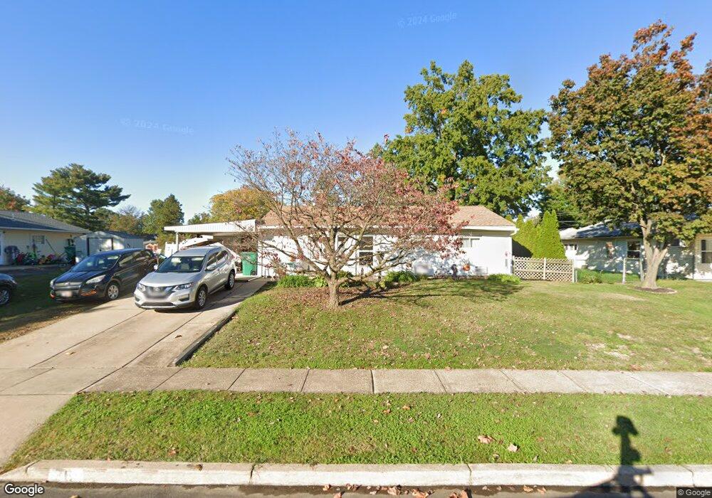
76 Balsam Rd Levittown, PA 19057
Estimated Value: $281,000 - $386,000
3
Beds
1
Bath
1,000
Sq Ft
$334/Sq Ft
Est. Value
About This Home
This home is located at 76 Balsam Rd, Levittown, PA 19057 and is currently estimated at $333,525, approximately $333 per square foot. 76 Balsam Rd is a home located in Bucks County with nearby schools including Truman Senior High School, First Presbyterian Church School, and Hope Lutheran School.
Ownership History
Date
Name
Owned For
Owner Type
Purchase Details
Closed on
May 11, 1976
Sold by
Murdock Sidney O
Bought by
Vincent Edmund Everett and Vincent Paula
Current Estimated Value
Create a Home Valuation Report for This Property
The Home Valuation Report is an in-depth analysis detailing your home's value as well as a comparison with similar homes in the area
Home Values in the Area
Average Home Value in this Area
Purchase History
| Date | Buyer | Sale Price | Title Company |
|---|---|---|---|
| Vincent Edmund Everett | $28,500 | -- |
Source: Public Records
Tax History Compared to Growth
Tax History
| Year | Tax Paid | Tax Assessment Tax Assessment Total Assessment is a certain percentage of the fair market value that is determined by local assessors to be the total taxable value of land and additions on the property. | Land | Improvement |
|---|---|---|---|---|
| 2025 | $4,236 | $15,600 | $4,680 | $10,920 |
| 2024 | $4,236 | $15,600 | $4,680 | $10,920 |
| 2023 | $4,205 | $15,600 | $4,680 | $10,920 |
| 2022 | $4,205 | $15,600 | $4,680 | $10,920 |
| 2021 | $4,205 | $15,600 | $4,680 | $10,920 |
| 2020 | $4,205 | $15,600 | $4,680 | $10,920 |
| 2019 | $4,190 | $15,600 | $4,680 | $10,920 |
| 2018 | $4,122 | $15,600 | $4,680 | $10,920 |
| 2017 | $4,060 | $15,600 | $4,680 | $10,920 |
| 2016 | $4,060 | $15,600 | $4,680 | $10,920 |
| 2015 | $2,874 | $15,600 | $4,680 | $10,920 |
| 2014 | $2,874 | $15,600 | $4,680 | $10,920 |
Source: Public Records
Map
Nearby Homes
- 150 Naomi Ct Unit 811
- 50 Micahill Rd
- 101 Idlewild Rd
- 23 Misty Pine Rd
- 57 Middle Rd
- 1019 Green Ln
- 62 Indian Creek Dr
- 212 Plumbridge Dr
- 145 Mill Dr
- 86 Wildflower Rd
- 35 Parkside Cir
- 47 Plumbridge Dr
- 84 Whitewood Dr
- 38 Plumtree Rd
- 3021 Bath Rd
- 2519 Woodlawn Dr
- 19 Prunewood Rd
- 2205 Liberator St
- 35 Inland Rd
- 5604 Fleetwing Dr
- 80 Balsam Rd
- 72 Balsam Rd
- 39 Broadleaf Rd
- 43 Broadleaf Rd
- 37 Broadleaf Rd
- 68 Balsam Rd
- 75 Balsam Rd
- 137 Blue Ridge Dr
- 33 Broadleaf Rd
- 71 Balsam Rd
- 66 Balsam Rd
- 134 Blue Ridge Dr
- 126 Blue Ridge Dr
- 29 Broadleaf Rd
- 67 Balsam Rd
- 141 Blue Ridge Dr
- 38 Broadleaf Rd
- 115 Blue Ridge Dr
- 136 Blue Ridge Dr
- 34 Broadleaf Rd